Leen Helmink Antique Maps
Antique sea chart of Java by Janssonius
The item below has been sold, but if you enter your email address we will notify you in case we have another example that is not yet listed or as soon as we receive another example.
Stock number: 19862
Zoom ImageCartographer(s)
Johannes Janssonius (biography)
Title
Insulae IAVAE
First Published
Amsterdam, 1659
This Edition
1659 first edition
Size
42.0 x 51.7 cms
Technique
Condition
excellent
Price
This Item is Sold
Description
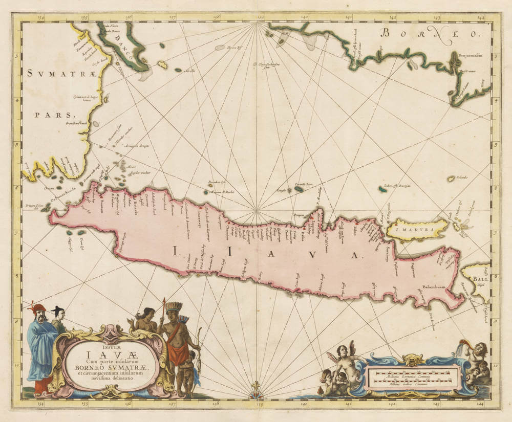
An important and beautiful Dutch sea chart of Java, by the great Amsterdam publisher Johannes Janssonius (1588-1664). The title, held in a decorative cartouche at the lower left, reads Insulae Iavae cum parte insularum Borneo, Sumatrae, et circumjacentium insularum novissima delineatio (Newest depiction of the island of Java with part of Borneo, Sumatra, and the surrounding islands).
Oriented with north to the top, the chart shows the whole length of Java, with the southeastern coast of Sumatra and the Sunda Strait to the west, the southern coast of Borneo across the top, and Madura, Bali, and the lesser islands to the east; the Dutch headquarters in the East Indies is marked at Batavia (Jakarta), with its small fort.
As a working sea-chart it is given over to the coasts: the shoreline is closely drawn and named, set with soundings and the radiating rhumb lines of two compass roses, while the interior is left almost blank, knowledge of it being of little use to a navigator and, in any case, still largely closed to the Dutch, whose concern was the coast and the roadsteads. The chart was based on the most recent manuscript navigation charts of the Dutch East India Company, the secret VOC material that underlay the printed sea-charts of the region. It is handsomely engraved, with two fine cartouches: the title cartouche at the lower left is flanked by figures of natives and Chinese merchants, while the scale of Dutch and French nautical miles at the lower right is surrounded by Neptune, a mermaid and putti.
Janssonius was the great rival of Willem and Joan Blaeu; his maritime atlas, the Waterwereld, formed the first part of Volume V of his composite Atlas Novus, and was the first sea-atlas in the modern sense. This chart of Java, with its companions of Sumatra and Borneo, was not part of the founding edition of 1650 but was introduced into the Waterwereld with the Latin edition of 1659. A classic and decorative sea-chart of Java, the more desirable in fine contemporary colour.
Rarity
One of the three regional East Indies sea-charts (with Sumatra and Borneo) introduced into the Waterwereld only with the Latin edition of 1659, the founding edition of 1650 having carried just four charts for all of Asia (a general Indian Ocean chart, Ceylon, the Bay of Bengal, and the Pacific). The Janssonius plates were issued to about 1680, in late multi-volume editions of the Atlas Novus and Atlas Maior that, overshadowed in the long rivalry with Blaeu, sold in modest numbers and survive in relatively few sets; the regional sea-charts are accordingly uncommon. The present plate was later acquired by Schenk & Valk, who re-issued it under their own imprint around 1700.
Significance
The first printed sea chart of Java, copied from the offical but secret vellum VOC navigation chart of the island.
Condition description
Very attractive collector's example of this well executed sea chart.
Johannes Janssonius (1588-1664)
Johannes Janssonius, more commonly known to us as Jan Jansson, was born in Arnhem where his father was a bookseller and publisher (Jan Janszoon the Elder). In 1612 he married the daughter of the cartographer and publisher Jodocus Hondius, and then set up in business in Amsterdam as a book publisher. In 1616 he published his first maps of France and Italy and from then onwards he produced a very large number of maps, perhaps not quite rivalling those of the Blaeu family but running a very close second in quantity and quality. From about 1630 to 1638 he was in partnership with his brother-in-law, Henricus Hondius, issuing further editions of the Mercator/Hondius atlases to which his name was added. On the death of Henricus he took over the business, expanding the atlas still further, until eventually he published an 11-volume "Atlas Major" on a scale similar to Blaeu's "Atlas Maior".
The first full edition of Jansson’s English County Maps was published in 1646 but some years earlier he issued a number of British maps in the Mercator/Hondius/ Jansson series of atlases (1636–44); the maps were printed from newly engraved plates and are different from the later 1646 issue and are now rarely seen. In general appearance Jansson’s maps are very similar to those of Blaeu and, in fact, were often copied from them, but they tend to be more flamboyant and, some think, more decorative.
After Jansson's death his heirs published a number of maps in an "Atlas Contractus" in 1666 and later still many of the plates of his British maps were acquired by Pieter Schenk and Gerard Valck, who published them again in 1683 as separate maps.
(Moreland and Bannister)