Leen Helmink Antique Maps
Sea chart of Sumatra, Singapore and parts of Malaysia by Johannes van Keulen II

Stock number: 19147
Zoom ImageCartographer(s)
Johannes van Keulen II (biography)
Title
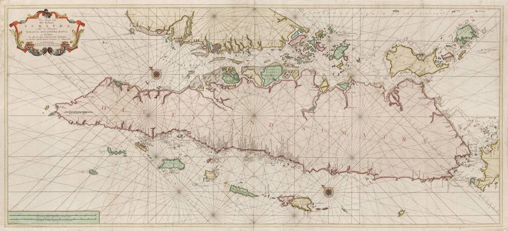
Zee-Caart van het Eyland Sumatra
First Published
Amsterdam, 1753
Size
50 x 112 cms
Technique
Condition
excellent
Price
$ 17,500.00
(Convert price to other currencies)
Description
Zee-Caart van
Het Eyland
SUMATRA,
Met de Straaten
MALACCA, SINCAPOERA, BANCA en SUNDA,
en alle de daar onderhoorende Eylanden,
met derselver bekende Dieptens Droogtens en Ankergronden.
te Amsterdam
by JOANNES VAN KEULEN,
op de hoek van de Nieuwe-brug Steeg
Sea Chart of
The Island
SUMATRA
With the Straights of
MALACCA, SINCAPOERA, BANCA and SUNDA,
and all the subordinate Islands,
with the known Depths Shoals and Anchor grounds of the same
[published] in Amsterdam
by JOANNES VAN KEULEN
at the corner of the New Bridge Alley
Majectic double page sea chart covering Sumatra, Singapore, parts of modern day Malaysia, and the western part of Java. A seminal map, and one of the first accurate charts of these waters.
The chart is oriented toward the northwest, and the degrees of latitude are thus marked along two diagonal lines. The scale is given in the lower left, in both (old) Dutch Nautical Miles (of 15 in one degree of latitude, corresponding to 4 modern Nautical Miles) as well as in English/French Nautical Leagues (of 20 in a degree, corresponding to 3 modern Nautical Miles). The chart has many essential data for navigation, including depth soundings in fathoms, little "*" symbols to indicate shoals, reefs and sandbanks, anchors to indicate safe anchor grounds, and text legends to explain the kind of sea bottom (coral, sand), to indicate sand banks that are visible at low tide only, and to point where fresh water can be found.
The chart was published in a now exceptionally rare sea atlas by Johannes (II) van Keulen, the Zee-Fakkel Part VI, first issued in 1753, the so-called secret atlas of the Dutch East India Company, of this atlas only a few copies have survived. The atlas was not commercially offered for sale, but was produced solely for use by the VOC on board of their East Indiamen.
For many regions in Asia and Africa, the printed maps from this atlas are the first, the best and the only accurate early charts.
For two centuries, from 1602 to 1799, the Dutch East India Company (the VOC) ruled the waters of Asia and Africa. Accurate charting of these waters was essential for successful and safe navigation.
The VOC had their own map making office. During the first 150 years, only secret manuscript charts were used, to minimize the risk of spreading the knowledge to competitors. But from 1753 onwards, a printed atlas was used, the van Keulen Zee-Fakkel Part VI, with printed charts to navigate the waters from the Cape of Good Hope to Japan.
For the VOC, there was a variety of reasons for switching from vellum to printed sea charts:
First, in the course of 150 years the knowledge of these waters had already leaked out to other European nations and secrecy was of less relevance.
Second, printed maps were more accurate and less prone to errors than manuscript copies.
Third, loose maps were impractical and sometimes lost despite the strict policies of use.
And last, but not least, printed maps were cheaper to (re-)produce than manuscript maps.
Condition
Printed on thick paper, intended for use a sea. A strong impression of the copperplate. White paper. Good margins. A magnificent example of the best available collector's sea chart of the region. Lacking in nearly all collections.
Johannes van Keulen (1654-1711)
Gerard van Keulen (son) (1678-c.1727)
Johannes van Keulen II (grandson) (active 1726-1755)
The Dutch produced a remarkable number of enterprising and prolific map and chart makers but not even the Blaeu and Jansson establishments could rival the vigour of the van Keulen family whose business was founded in 1680 and continued under their name until 1823 and in other names until 1885 when it was from wound up and the stock dispersed at auction.
Throughout the history of the family, the widows several of the van Keulens played a major part, after their husbands' deaths, in maintaining the continuity of the business. The firm was founded by Johannes van Keulen who was registered as a bookseller in Amsterdam in 1678. In 1680 he published the first part of his 'Zee Atlas' which, over the years, was expanded to 5 volumes and continued in one form or another until 1734. More ambitious and with a far longer and more complicated life was his book of sea charts, the 'Zee-Fakkel', first published in 1681–82, which was still being printed round the year 1800. A major influence in the development of the firm was the acquisition in 1693 of the stock of a rival map publisher, Hendrik Doncker.
Although the firm was founded by Johannes van Keulen, he was primarily a publisher; it was his son, Gerard, a talented engraver, mathematician, Hydrographer to the East India Company, who became mainspring of the business which not only published charts but also books on every aspect of geograpy, navigation and nautical matters,
(Moreland and Bannister)
It was grandson Johannes van Keulen (II) who in 1753 produced Volume VI of the Zee-Fakkel for the VOC East Indiamen, containing printed charts for the navigation covering the waters from the Cape of Good Hope to Nagasaki . The atlas was not commercially sold and only for use on board of VOC ships, therefore it is also refered to as the 'secret atlas' odf the VOC. The engraving quality and craftmanship surpasses that of all earlier printed sea charts.
Sea charts from the secret atlas are among the rarest and most desirable sea charts for collectors.


