Leen Helmink Antique Maps
Antique map of Far East, Australia, Indian Ocean by van Keulen
The item below has been sold, but if you enter your email address we will notify you in case we have another example that is not yet listed or as soon as we receive another example.

Stock number: 19233
Zoom ImageCartographer(s)
Johannes van Keulen II (biography)
Title
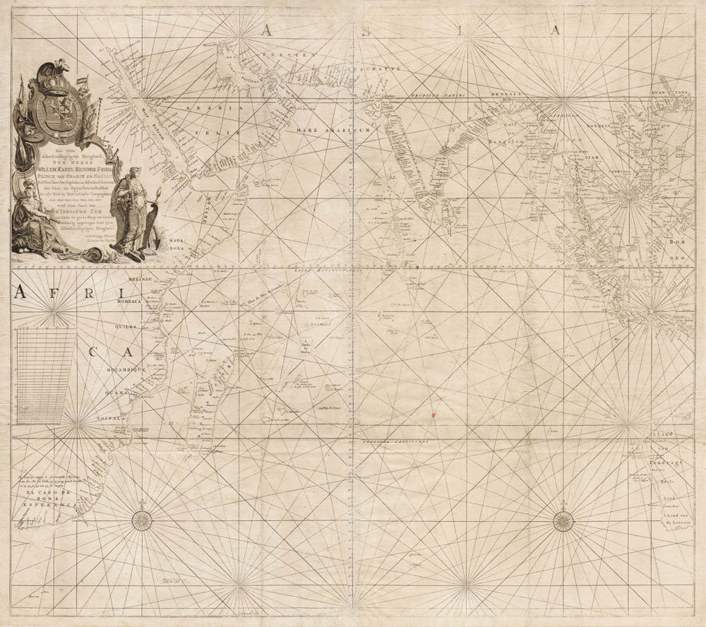
Caart van D'INDISCHE ZEE van Cabo de goede Hoop tot Canton
First Published
Amsterdam, 1753
This Edition
Amsterdam, 1753
Size
87 x 97 cms
Technique
Condition
Excellent
Price
This Item is Sold
Description
Title cartouche
Aan zyne | Allerdoorlugtigste Hoogheid | DEN HEERE | WILLEM KAREL HENDRIK FRISO | PRINCE VAN ORANJE EN NASSAU [...] werd deze Caart van D'INDISCHE ZEE | van Cabo de goede Hoop tot Canton / eerbiedig opgedragen door zyne | Allerdoorlugtigste Hoogheids | onderdanige Dienaar | Joannes van Keulen
J.C.Philips inv.et del.: J. van Jagen Sculps. - [Amsterdam] : Ioannes van Keulen
First state of Joannes van Keulen II's large scale VOC navigation chart of the Indian Ocean on Mercator Projection.
Not included in any atlas, separately issued as a printed chart for the VOC.
The chart is of utmost significance for the VOC navigation of the Indian Ocean, and was used by all VOC ships after 1755, when it replaced the vellum charts for the Indian Ocean. This large sea chart is excruciatingly rare, despite its use on board of all VOC East Indiamen, in three copies (one for the captain, and one each for the first and second steersmen or pilots. Interestingly, the chart was still in active use in the early 1800s, when it is listed on the official ship's inventory of charts as issued by the Council of the Asian Affairs.
The chart is known in three states, as follows:
Proof state: an incomplete proof state is known, with manuscript title and dedication pasted on the chart
(1 example known: Amsterdam University Library).
State 1: After 1753 - With printed title and dedication
(2 examples known: Utrecht University Library, The Hague Dutch National Archives)
State 2: Identical to state 1, but with a printed note south of Java
(2 examples known: Utrecht University Library, The Hague Dutch National Archives)
A large and highly significant chart that is lacking in all collections. No copies in collections outside Europe.
Condition
First state. Traces of use at sea, including small pinholes from pair of dividers. Minor imperfections but overall in excellent collector's condition.
Literature
Dirk de Vries, Günter Schilder, Willem Mörzer Bruyns, Peter van Iterson and Irene Jacobs. The Van Keulen Cartography Amsterdam 1680-1885. Illustrated page 87 (Ill. 28). Discussed in detail page 186 (Chart 212.1-3).
Günter Schilder and Hans Kok. Sailing for the East. Illustrated page 185 (Ill. 10.3). Discussed in detail on pages 183-185.
Johannes van Keulen (1654-1711)
Gerard van Keulen (son) (1678-c.1727)
Johannes van Keulen II (grandson) (active 1726-1755)
The Dutch produced a remarkable number of enterprising and prolific map and chart makers but not even the Blaeu and Jansson establishments could rival the vigour of the van Keulen family whose business was founded in 1680 and continued under their name until 1823 and in other names until 1885 when it was from wound up and the stock dispersed at auction.
Throughout the history of the family, the widows several of the van Keulens played a major part, after their husbands' deaths, in maintaining the continuity of the business. The firm was founded by Johannes van Keulen who was registered as a bookseller in Amsterdam in 1678. In 1680 he published the first part of his 'Zee Atlas' which, over the years, was expanded to 5 volumes and continued in one form or another until 1734. More ambitious and with a far longer and more complicated life was his book of sea charts, the 'Zee-Fakkel', first published in 1681–82, which was still being printed round the year 1800. A major influence in the development of the firm was the acquisition in 1693 of the stock of a rival map publisher, Hendrik Doncker.
Although the firm was founded by Johannes van Keulen, he was primarily a publisher; it was his son, Gerard, a talented engraver, mathematician, Hydrographer to the East India Company, who became mainspring of the business which not only published charts but also books on every aspect of geograpy, navigation and nautical matters,
(Moreland and Bannister)
It was grandson Johannes van Keulen (II) who in 1753 produced Volume VI of the Zee-Fakkel for the VOC East Indiamen, containing printed charts for the navigation covering the waters from the Cape of Good Hope to Nagasaki . The atlas was not commercially sold and only for use on board of VOC ships, therefore it is also refered to as the 'secret atlas' odf the VOC. The engraving quality and craftmanship surpasses that of all earlier printed sea charts.
Sea charts from the secret atlas are among the rarest and most desirable sea charts for collectors.
Related Categories
Related Items


