Leen Helmink Antique Maps
Antique map of Batavia by Frederick de Wit

Stock number: 19409
Zoom ImageCartographer(s)
Frederick de Wit (biography)
Title
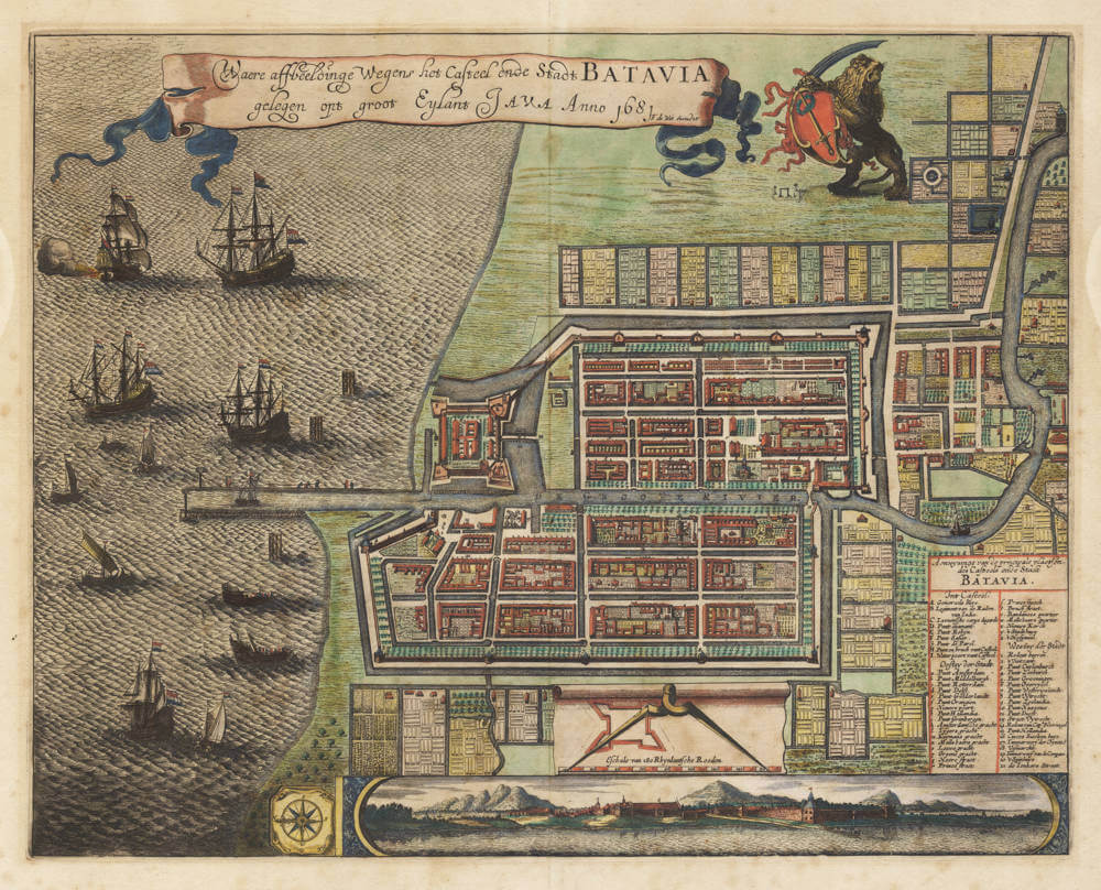
Waere affbeeldinge Wegens het Casteel ende Stadt BATAVIA gelegen opt groot Eylant JAVA Anno 1681 F. de Wit Excudit
First Published
Amsterdam, 1681
This Edition
1681 first edsition
Size
40.2 x 50.8 cms
Technique
Condition
very good
Price
$ 5,500.00
(Convert price to other currencies)
Description
Waere affbeeldinge Wegens het Casteel ende Stadt BATAVIA gelegen opt groot Eylant JAVA Anno 1681 F. de Wit Excudit
True depiction of the Castle and the City of BATAVIA, situated on the grand Island Java Anno 1681 published by F. de Wit
Frederick de Wit's rare and sought-after city plan of Batavia (Djakarta, Jakarta), headquarters of the East Indies for the Dutch VOC from 1628 onwards and for centuries the pearl of the Indies.
The detailed plan of the walled city of Batavia with the roadstead, the Castle and the city as seen from the west (the "evening side"). North is at the left of the map. The roadstead is filled with VOC East Indiamen at anchor.
Along the bottom is a decorative panorama of the city as seen from the roadstead.
The coat of arms of the city is in the upper right, held by the Dutch lion. At his feet we see the gallow fields east of the city.
An extensive numbered index on the right lists the principal buildings and places. Outside the walled city are rice and sugar fields, cattle stables, fortresses and bastions.
The plan covers the area of the old city with canals and Dutch architecture and canal houses, today's 'Sunda Kelapa' around the old harbour and fish market and the East India Company warehouses. A stunning piece of Indonesian and Dutch history.
The map is based on a larger separately issued broadsheet map of ca 1650 by Clement de Jonghe.
Condition
First edition, first state (much rarer than the later reissue of ca 1721 by Covens and Mortier). Thick paper, wide margins. Paper mellow yet very authentic look and feel. Vibrant original colour. A desirable collector copy of the best map of the city.
Frederick de Wit (1629-1706)
Early Life and Beginnings in Amsterdam
Frederick de Wit was born around 1629 in Gouda, a city known for its cultural and intellectual contributions during the Dutch Golden Age. His family was Protestant, and by 1648, 18 or 19 year old De Wit had moved to Amsterdam, a city at the heart of Dutch trade, culture, and mapmaking. Here, he served his apprenticeship under the tutelage of Joan Blaeu, whose family was already famous for producing some of the world's finest atlases and maps.
Establishment in Amsterdam
In 1654, de Wit set up his own printing office and shop, initially named "De Drie Crabben" (The Three Crabs), which was also the name of his residence on Kalverstraat. The following year, he renamed it "De Witte Pascaert" (The White Navigation Chart), signaling his focus on cartography. His early works included a plan of Haarlem in 1648 and illustrations for Antonius Sanderus’s "Flandria Illustrata", but it was his independently engraved map of Denmark in 1659 that marked his entry into the broader mapmaking world.
Cartographic Contributions and Style
De Wit's maps were distinguished by their accuracy, decorative borders, and elaborate cartouches often depicting classical mythology or allegorical scenes. His most famous work, "Nova Totius Terrarum Orbis Tabula," was a world map first published in 1660. The map demonstrated his skill in both geography and artistic design. Over the decades, he produced numerous sea charts, town plans, and wall maps, which were not only navigational aids but also sought after for their beauty and decorative value.
By the 1670s, de Wit was producing larger atlases like the "Atlas Maior" and "Nieuw Kaertboeck van de XVII Nederlandse Provinciën". These atlases combined his own engravings with those he had acquired, showcasing his entrepreneurial spirit. His maps of the Netherlands were particularly notable for their detailed depiction of the Dutch landscape, including cities, waterways, and dykes, reflecting the country's complex relationship with its environment.
Personal Life and Guild Membership
In 1661, de Wit married Maria van der Way, which not only brought him personal happiness but also the privileges of Amsterdam citizenship. This allowed him to join the prestigious Guild of Saint Luke in 1664, which was essential for artists and engravers in the city. His involvement with the guild underscores his standing in the artistic community of Amsterdam.
Later Years and Legacy
De Wit's business thrived, especially after the death of his mentor Blaeu, from which he acquired many copper plates when they were dispersed at auction, positioning him as one of the leading cartographers in Amsterdam. He continued to expand his catalog, ensuring his maps were up-to-date with the latest geographical discoveries. His attention to detail and the aesthetic quality of his work made his maps popular among the elite, scholars, merchants, and navigators alike.
When Frederick de Wit passed away in July 1706, his wife Maria managed the business until 1710. After her death, the vast collection of copper plates was auctioned off, with many going to Pieter Mortier (1661-1711), who used them to further his own publishing empire, Covens & Mortier. In 1721, the copperplates were sold in auction by the heirs of Mortier's widow, and were acquired by the Ottens publishing house in Amsterdam. These transactions illustrate de Wit's lasting influence on the mapmaking industry.
Cultural Impact and Modern Appreciation
De Wit's work encapsulates the spirit of the Dutch Golden Age – a period of unprecedented artistic and scientific achievement. His maps are not merely tools for navigation but are also pieces of art that reflect the cultural pride of the Dutch in their maritime and cartographic prowess. Today, his maps are treasured in collections around the globe, from libraries to smaller, specialized map collections. They are frequently exhibited in museums as exemplars of the Dutch art of cartography, admired for their precision, beauty, and historical significance.
Frederick de Wit's legacy is one of a craftsman whose maps not only charted the physical world but also captured the imagination of those who used them, contributing to the enduring allure of an age when maps were as much about exploration as they were about art.
Related Categories
Related Items


