Leen Helmink Antique Maps
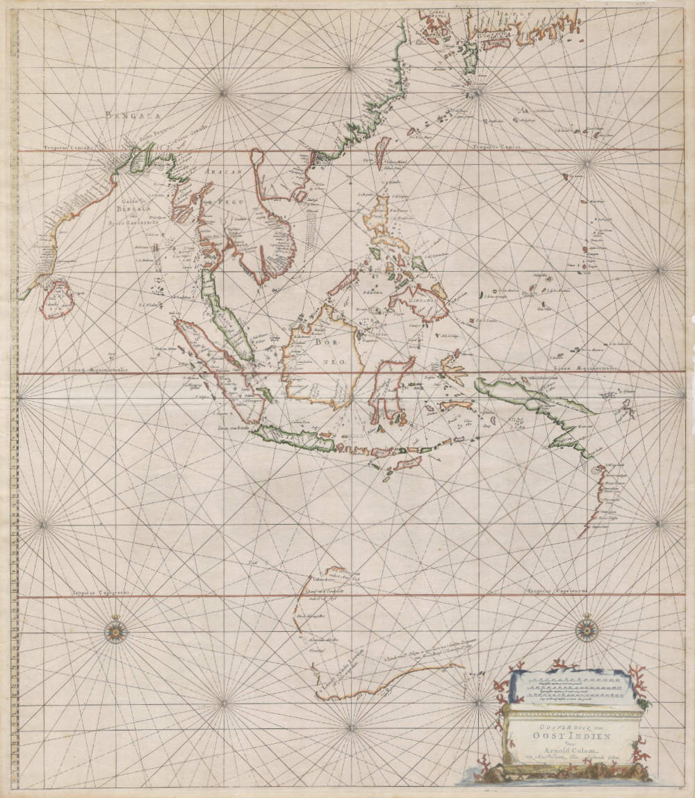
Antique navigation chart of the East Indies and Australia

Stock number: 18952
Zoom ImageCartographer(s)
Arnold Colom
Title
Ooster Deel van OOST INDIEN
First Published
Amsterdam, 1658
This Edition
1658 first edition
Size
54.0 x 63.0 cms
Technique
Condition
excellent
Price
$ 32,500.00
(Convert price to other currencies)
Description
Arnold Colom's oversized sea chart of the Far East and Australia.
Arguable the best and rarest of all sea charts of the Far East and Australia, the last and most impressive of the pre-Tasman charts.
Condition
Excellent condition. In stunning original color.
The plate has a fascinating history and would be re-issued over a period of 70 years:
I. Issued by Arnold Colom, sometime between 1656 and 1658. This is the chart shown here, and in the famous Hubbard collection [Shown online here]. The National Library of Australia also has a copy [online map RM-308].
II. The plate changes hands and ends up in the possession of Hendrick Doncker, who changes the name in the cartouche and publishes the chart otherwise unchanged sometime between 1675 and 1678.
III. Finding the format of the oversize plate too unwieldy, Doncker has the plate cut (right side and bottom) and uses it in his Nieuwe Groote Vermeerderde Zeeatlas 1676-1688. You can see two examples of this: one in Tooley's Mapping of Australia and the other on the website of the National Library of Australia [online map T-449].
IV. 1688 Doncker decides to update the plate and fills in the northern coast of Australia, gussies up the cartouche and adds a second mileage scale in the upper left side. Tooley includes this chart as number 452. The National Library of Australia also has a copy [online map T-452].
V. Doncker dies and at some point in time the van Keulen's come into possession of the plate. The name of Doncker is erased and the title is changed to Oosterdeel van Oost Indien Streckende van Ceilon tot Iapon en tot Landrones (sic) Ilanden ... by Ger: van Keulen ... Koeman mentions it in Keu 124 E [265] and it is also mentioned in the index of charts.
(Hubbard)
Rarity
The first state of 1658 is the rarest of all five states.
Condition description
Excellent example of the rare first state (of five). Attractive original colour.


