Leen Helmink Antique Maps
Eastern Hemisphere Globe Gores by Johann Oterschaden

Stock number: 19149
Zoom ImageTitle
Nova et integra universi Orbis descriptio.
First Published
Antwerp?, 1603
This Edition
Nuremberg, ca 1650
Technique
Condition
excellent
Price
$ 8,500.00
(Convert price to other currencies)
Description
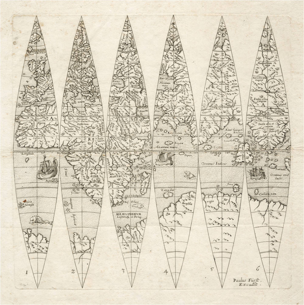
Extremely rare beautifully engraved set of 6 globe gores, comprising the Eastern Hemisphere of Johann Oterschaden's globe.
The gores depict Europe, Africa, most of Asia and the Indian Ocean, based upon the cartographic details prevailing in about 1540 to 1550.
No more than three copies are known of the complete globe. In 2018, Christie's New York auctioned a silver version of the globe for USD 62,500 (Sale 16082 lot 20). Shirley records one example of this second state by Paul Furst.
The cartographic image goes back to the Oronce Fine 1531 map of the world and the Caspar Vopell globe of 1536. The discoveries shown are based on the Portuguese entering the Indian Ocean from the west (Hemispherium Lusitanor et Portug., Calicut, Malacha) and Magellan's expedition entering the Indian Ocean from the east (Callenzuam).
Condition
Eastern hemisphere only. Dark and even imprint of the copperplate. Minor paper spotting in upper left margin, outside the printed area. Wide margins all around. No restorations or imperfections. Excellent collector's condition.
Christie's on this second state of the copperplate
An extremely rare set of half-gores for a 6½-inch diameter globe. These gores, forming the eastern hemisphere, are reissues of those produced by Joannes Oterschaden in about 1603 (see Shirley World 237). Based on the globes produced by Demongenet, c.1560, and Vopel, c.1536, their geography was almost a century out of date by the time Fürst published them. Fürst, a Nuremberg-based publisher and printseller, must have seen a market for these type of reissues, since he also republished other globe gores and planispheres, including of Isaac Habrecht II which were first published in the 1620s. See Shirley World 237.
A set of 6 engraved gores, on one sheet (339 x 318mm), numbered 1-6 to left-hand side of corresponding gore, the gores showing the eastern hemispshere of a terrestrial globe with a diameter of 16.4cm (6½ in.), three ships and three sea monsters decorating the southern oceans.
(Christie's)
The Mapping of the World
Little is known of Johann Oterschaden whose globe gores are part of a set which includes celestial gores and a plate of horizon circles. The ma nature on the dedication, Joañes Oterschaden Belga, indicates his origin the Low Countries where he is known to have worked in the late sixteenth and early seventeenth centuries. The Bishop of Cominges, to whom the gores are dedicated, occupied his seat from 1580 to 1613.
The gores are neatly engraved and show the world outline as known some fifty or sixty years previously, without recognition of the work of Mercator, Ortelius, or even Gastaldi and his successors. The East Indian islands are referred to as islands ‘recently discovered 1520'.
The gores are ascribed to c.1603 because of their very close similarity to the gores of Willem Nicolai (Shirley 241) which bear the date 1603. It is not known which cartographer's work is the earlier, or which copied from the other. There are also parallels between Oterschaden's work and the globe of Christoff Schniepp, produced in Augsburg in about 1600. A later re-issue by Paul Fürst of Nuremberg in the mid-seventeenth century has been recorded.
SMA; Schloss Wolfegg; Hispanic Society of America. H.P. Kraus, Catalogue 124 (Supplement), 1969, item IV (date given as 'late 16th century'); Stevenson II, plate 140 (date given as '1675'); Franz Wawink, Der Erdgloben Des Johannes Oterschaden, Der Globusfreund, Vienna, 1978, p. 166.
(Shirley 237)
Copper and silver globes
A famous copper globe (the Welser globe) is nearly identical to the Oterschaden (and the Nicolai) globe, they are presumed to go back to the same source. The Welser globe is undated but is believed to be from 1545-1550. It was made by Christoff Schniepp or the famous Welser family of German financiers. They were bankers to the Habsburgs and financiers of Charles V, Holy Roman Emperor. They financed expeditions to the Indies and made an attempt to colonise Venezuela. Hand-etched on copper, it is a one-of-a-kind piece whose cartography was inspired by contemporary world maps and globes. For the Welsers, a prestigious object such as this was a means of asserting their power and wealth and the geographical reach of their trading ambitions.
In the mid-16th century, the Holy Roman Empire dominated European trade and finance, notably with families of merchants and bankers such as the Fuggers and the Welsers. The Wesler Globe is now in Bibliotheque Nationale Paris, including an online 3D version. It is frequently included in prestigious exhibitions.
In 2018, Christie's New York auctioned a silver version of this globe for USD 62,500 (Sale 16082 lot 20).
Literature
Franz Wawrik, Der Erdglobus des Johannes Oterschaden, Der Globusfreund Nr. 25/27, FESTSCHRIFT zum 25jährigen Bestand des CORONELLI-WELTBUNDES DER GLOBUSFREUNDE. BERICHT über das V. INTERNATIONALE SYMPOSIUM DES CORONELLI-WELTBUNDES DER GLOBUSFREUNDE (MAI 1978 (für 1977/78/79)), pp. 155-167.
Rodney Shirley, The Mapping of the World, entries 237 (Oterschaden) and 241 (Nicolai).
Frederic Muller, Remarkable Maps, vol 1, items 5 and 6.
Johann Oterschaden (fl.1600-1603)
Very little is known of Oterschaden, not even his nationality. He signed his globe gores with the epithet "Belga" indicating the Low Countries, but his globes are dedicated to the Bishop of Comminges in the south of France who held office 1580-1613. His work is related to that of Gulielmus Nicolai, working in Lyon and Avignon.
To complicate matters further, the horizon rings associated with the surviving globes by him at Greenwich (GLB0119 & GLB0120) have the wind names in German, from which Dekker (Globes at Greenwich) infers a possible Lorraine background and suggests Strasbourg as his town of residence.
Oterschaden’s cartography is not derived from the early 17th-century globes produced by the Hondius and Blaeu workshops but seems to be based on sources from 50 years earlier, and is most similar to the gores of Francois Demongenet of c.1560 (see Christie’s King Street 12 July 2017 lot 199 for a German globe in the Demongenet tradition). As with that globe, the size of this example is suggestive of it having formed part an elaborate armillary sphere or an astronomical clock. The style of engraving on the globe is representative of the late 16th- and early 17th-century globe and instrument makers of Germany and Flanders.
(Christie's)
Paul Fürst (1608-1666)
Paul Fürst's father was a fustian weaver from Nuremberg, who had his son baptized on February 7, 1608.
By marrying Helena Susanna Schnelling, the daughter of the art dealer Peter Schnelling von Antorf on March 15, 1637, Paul Fürst inherited the business of his wife's grandfather, the art dealer Balthasar Caymox, in the same year.
He continued to run the company under his own name. Above all, Fürst published illustrated sheets, pamphlets and copper engraving collections. On September 11, 1666, Paul Fürst committed suicide. His bookshop existed until 1703/04 under the name Paul Fürst Wittib und Erben.
(Wikipedia)
Willem Nicolai
Very little is known about Guiljelmus Nicolai (Willem Claeszoon); he appears to have been a publisher and engraver, with Tooley's Dictionary of Mapmakers stating: 'thought to have worked in Lyons and Avignon, also possibly Leiden.' The confusion about Lyon and Leiden comes from these gores, because the imprint states 'Lugduni', which refers to modern-day Lyon in France, as well as Leiden, as chosen by Shirley. This might be because he is described as 'Gulielmus Nicolai Belga' in the imprint, referring to the Netherlands; and secondly, the only other set of these gores is in the University of Leiden.
Nicolai's cartography is not derived from the early 17th-century globes produced by the Hondius and Blaeu workshops but is based on sources from half a century earlier, and is most similar to the 1542 globe of Caspar Vopell.
Related Categories
Antique maps of the South Pole
Antique maps of the North Pole
Antique maps of the World
Antique maps of Europe
Antique maps of Australia
Antique maps of China
Antique maps of Southeast Asia
Antique maps of India and Ceylon
Antique maps of the Middle East
Antique maps of Asia
Antique maps of Africa
Old books, maps and prints by Johann Oterschaden
Old books, maps and prints by Paul Fürst
Old books, maps and prints by Willem Nicolai
Related Items


<BR>
Abraham Ortelius<BR>
Caspar Vopelius")