Leen Helmink Antique Maps
Antique map of the World by Nicolai
The item below has been sold, but if you enter your email address we will notify you in case we have another example that is not yet listed or as soon as we receive another example.

Stock number: 18930
Zoom ImageCartographer(s)
Willem Nicolai (biography)
Title
Nova et integra universi Orbis descriptio.
First Published
Leiden (or Lyons?), 1603
This Edition
Leiden (or Lyons?), 1603
Size
each sheet 26 x 25.5 cms
Technique
Condition
excellent
Price
This Item is Sold
Description
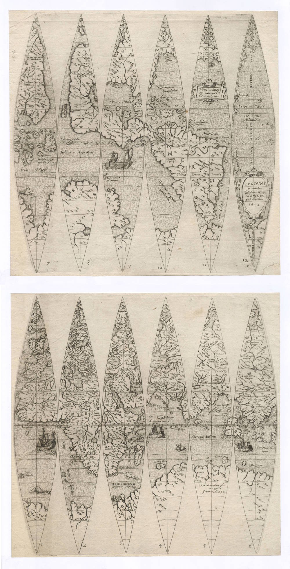
An extremely rare and important set of gores for a terrestial globe, of utmost significance for the early exploration and mapping of the world in general and to the early mapping of the Indian and Pacific Oceans, America and Australia in particular.
This is the second complete example known. The only other copy is in the Leiden University Library.
The set consists of 12 engraved gores on two sheets, 6 gores to each sheet, numbered 1-6 and 7-12, each sheet 260 x 255 mm. The gores are intended for a terrestrial globe with a diameter of 165 mm (6½ inches). The title cartouche is in gore 11, east of North America. The impressum with place, author and date is in a cartouche on gore 12, east of South America.
Nicolai's engraving is dated 1603 in the Southern Atlantic Ocean. The date is puzzling and questioned because the cartography reflects the up-to-date knowledge of around 60 years before, and is based on Magellan's circumnavigation. In fact, the East Indian islands are labelled as “recently discovered 1520”. Furthermore, there is no recognition of the important work done by Ortelius, Mercator or even Gastaldi. This is because Nicolai’s work was modelled on the globes made by Caspar Vopell and Francois Demongenet in 1536, 1542 and 1560 respectively, which show the newly-found central America but lack the lands identified later in the sixteenth century.
Condition
A dark and even imprint of the copperplate. Thick and clean paper, with no discoloration. Margins all around. No restorations or imperfections. A pristine example of a seminal item that is lacking in all collections.
Cartographic content (a summary of Warwik's publication)
The cartographic image of this globe is about 60 years older than the date of 1603 that is given in the title cartouche, meaning that is is either copied from an archaic model or it is a re-issue of an older plate. The globe content is based on the Caspar Vopell 28 cm globe of 1542 (see for instance these reproductions of his Western Hemisphere and Southern Hemisphere). The title is identical to Vopell's title, the toponyms are all from Vopell, and the cartographic image is nearly identical except for two differences. The first difference is that Vopell has America joined with Asia, whereas Nicolai has them separated by a sea strait of 10-15 degrees of latitude. The second difference is that Vopell does not yet have the Orellana discovery of the Amazon River in 1541-1542.
Nicolai's engraving is similar to a set of undated gores by Joannes Oterschaden, but it is not known how they are related.
Europe
Because of the size of the globe, the maker had to restrict to the most important features of Europe. Upper case lettering is used for HISPANIA, GALLIA, and GERMANIA, and italic lower case lettering for the other countries, including Portugal with Lusitania south of it. While southern Europe and the Meditteranean Sea are quite accurate, northern Europe is more inaccurate, especially Scandinavia. Lapland has pygmies: Pigmei finlapie. Note that the last two letters of the inscription EUROPA are missing.
Asia
Asia still has a strong Ptolemaic character, especially in the nomenclature. There is an India citra, an India Ultra Gangem, a Sinus Gangetis a Sinus Magnus, in the interior Imaus mons with Scythia intra Ind and Scythia extra Ind. In the far north we see Pliny's cape of Tabin. The empire of Serica (the Land of the Silk) is the ancient Greek/Roman reference to China.
Many toponyms are from Marco Polo's journal, especially in eastern Asia. We see the Empire of the great Cham with a crowned emperor, Cathay, Quinsay. Karakorum, the capital of the Tartar emperor, is shown as Coran et Cotan. The island of Zipangri (Japan) is east of Asia, but closer to America than to Asia. Desertum Lop (The desert of Lop) has been moved even further from Asia into western America. The mythical lands or monsters of Gog et magog are at the far eastern end of Asia, north of the Pigmei.
The Indies and South East Asia already show the results of the early Portuguese voyages of discoveries. India has the port of Calicut, reached by Vasco da Gama in 1497-99. Malacha is depicted, as well as the port or province of Cantao (Canton) in China. The Molucca spice islands have a legend Insulae novae inventa A° 1520, refering to Magellan's voyage. Several The globe has the earliest Magellan/Pigafetta representation of the Philippine islands, including Suban (Cebu), where Magellan was killed. Burnei, Java minor and Porn are early references to the island of Borneo. Under the Southeast Asian Islands is the inscription Archi Pelagus, to emphasize the nature of the area. The Indian Ocean is named Oceanus Indicus and Oceanus orieta[n]lis.
Arabia is in the Ptolemaic rendering, except that Mecha has been added, which is very early for Western maps that go back to the 1540s.
Africa
Africa follows the common depiction of the mid 16th century, following the travel accounts of Ludovico Varthema for East Africa and Cadamosto for West Africa. The interior still follows the sources from antiquity, with the Nile sources in the Lunae Montes (Mountains of the Moon). The Niger river system also follows the Ptolemaic tradition. An elephant is depicted in southern Africa, together with a flying snake. Portuguese trade caravels are depicted around Africa and in the Indian Ocean.
Underneath Africa, in accordance with the Treaty of Tordesilas of 1494, the Eastern Hemisphere is labeled as Portuguese (HEMISPHERIUM Lusitanor, et Portug.), while the Western Hemisphere is labeled as Spanish (Hispanorum hemispherium).
America
As with all 16th century maps, the early depiction of the New World is of particular interest.
The outline of South America is shaped more correctly than with Ortelius and others in the 16th century. The most important rivers can be identified. The Amazon River flows from east to west, as explored by Orellana in 1541-42. It flows into a Mare Dulce (Sea of fresh water, caused by the Amazon River). The Rio de la Plata (River Plate) and Magdalena River are quite up-to-date. Most place names date back to Magellan's first circumnavigation of 1519-22. In large capitals, the name AMERICA is written over the whole of South America, in smaller italics it also has the older name Nova Terra. It has inventa 1497, a common inaccuracy for the discovery of the South American mainland. Peru is labeled as a province, indicating it has already been conquered and incorporated in the Spanish Empire. Brasilia egio is south of Papagalli regio which is south of Canibales.
The Caribbean is named Sinus S. Michael and has Iucatan as an island, the islands of Cozmella (Cozumel), Cuba, Hispaniola, Iamaica and the mythical Island of Antiglia. The Bahama islands that Columbus discovered are shown as Bori, Selan, and Canibalorum Insulae. Mexico City (Temistitan) is shown as a port in a bay on the Pacific coast, with Marco Polo's hearsay island of Japan (Zipangri), much closer to America than to Asia.
North America is named HISPANIA NOVA and is separated from Asia by a narrow strait. This is a major difference with the Vopell globe of 1542 on which this globe is based. Vopell's globe has North America as part of eastern Asia. This was a contested and controversial issue at the time, so much so that Vopell gives an elaborate explanation on his world map of 1545 to defend his choice by explaining that Charles V, emperor of the Holy Roman Empire including the Americas, had personally reassured scientists during a visit to Cologne that North America was definitely part of Asia.
Topographical entries are sparse for North America. The southeast has Terra Florida. Canada's northeast is given as Baccalearum regio, (the region of codfish). The island south of it, named Bovica, may well refer to Cape Breton Island, where the Portuguese under João Álvares Fagundes had established a fishing colony as early as 1521-22. This Portuguese colony's fate is unknown, but it is mentioned as late as 1570. The Mississippi is indicated as a large river, but not named. Cinyscole most probably refers to the legendary seven cities of Cibola. There is no trace of California, even though it's southermost point had already been discovered in 1532. Some of Marco Polo's toponyms have spilled over from the Far East into North America (Desertum Lop, Campestria bergi). East of North America, in accordance with the Treaty of Tordesilas of 1494, the Western Hemisphere is labeled as Spanish (Hispanorum hemispherium).
The Mariana Islands, discovered by Magellan, are shown in the middle of the Pacific right on the equator as Latronum Insulae (Ladrones islands, Islands of the Thieves). Pigafetta writes: "Those people are poor, but ingenious and very thievish, on account of which we called those three islands the islands of Ladrones."
Australia, the Southland and the Pacific
The Nicolai globe is of special interest to Australia and the Pacific, see for instance Issue 37 of the Australia on the Map Division of the Australasian Hydrographic Society.
The southern continent is quite pronounced and has three named regions:
Psitacorum terra (Land of the Parrots).
Brasilia regio with a city on a river and a crown to indicate that it is a kingdom. Near the coast, in the southern Indian Ocean, are the islands of Iona and Callenzuam, that first appear on Waldseemüller's 1507 wall map of the world.
Regio Patalis, a mysterious region described in antiquity by Pliny the Elder and Strabo. Many 16th century cosmographers situated this region on a large promontory of the southland, roughly in the area of the Australian continent. Like Brasilia regio, it has a crown to indicate that it is a kingdom.
The southland has an inscription Terra nondum plene cognita Inventa A°. 1499 (Lands not yet fully known, discovered in the year 1499). This has sometimes been used as evidence of an early Portuguese discovery of Australia.
A big promontory in the southern Pacific is labelled as Regio Patalis, a mythical land that has often been identified with Australia. Symbols of crowns indicate multiple kingdoms on the southland.
Because the cartographic image is of 1542 or shortly after that, the Pacific cartography is based solely on the discoveries of Magellan, the first European explorer to circumnavigate the world and to navigate the Pacific.
The middle of the Pacific has the inscription Indicum et Austr. Mare (Indian [Seas] and South Seas). Close to the Southland, two islands are situated, Infortunatae et desertae, (Unfortunate and uninhabited isles), so called by Magellan, because they had neither men nor suitable provisions or fresh water.
In the southern Pacific, Vopell's OCEANUSMA|GELLANICUS (Magellan's Ocean) has been corrupted into Oceanus Magnus Gellanicus, suggesting that the engraver who copied toponyms from Vopell's globe was not proficient in cartography.
Copper and silver globes
A famous copper globe (the Welser globe) is nearly identical to the Nicolai globe, they are presumed to go back to the same source. The Welser globe is undated but is believed to be from 1545-1550. It was made by Christoff Schniepp or the famous Welser family of German financiers. They were bankers to the Habsburgs and financiers of Charles V, Holy Roman Emperor. They financed expeditions to the Indies and made an attempt to colonise Venezuela. Hand-etched on copper, it is a one-of-a-kind piece whose cartography was inspired by contemporary world maps and globes. For the Welsers, a prestigious object such as this was a means of asserting their power and wealth and the geographical reach of their trading ambitions.
In the mid-16th century, the Holy Roman Empire dominated European trade and finance, notably with families of merchants and bankers such as the Fuggers and the Welsers. The Wesler Globe is now in Bibliotheque Nationale Paris, including an online 3D version. It is frequently included in prestigious exhibitions.
In 2018, Christie's New York auctioned a silver version of this globe for USD 62,500 (Sale 16082 lot 20).
Literature
Franz Wawrik, Der Erdglobus des Johannes Oterschaden, Der Globusfreund Nr. 25/27, FESTSCHRIFT zum 25jährigen Bestand des CORONELLI-WELTBUNDES DER GLOBUSFREUNDE. BERICHT über das V. INTERNATIONALE SYMPOSIUM DES CORONELLI-WELTBUNDES DER GLOBUSFREUNDE (MAI 1978 (für 1977/78/79)), pp. 155-167.
Rodney Shirley, The Mapping of the World, entries 237 (Oterschaden) and 241 (Nicolai).
Frederic Muller, Remarkable Maps, vol 1, items 5 and 6.
Willem Nicolai
Very little is known about Guiljelmus Nicolai (Willem Claeszoon); he appears to have been a publisher and engraver, with Tooley's Dictionary of Mapmakers stating: 'thought to have worked in Lyons and Avignon, also possibly Leiden.' The confusion about Lyon and Leiden comes from these gores, because the imprint states 'Lugduni', which refers to modern-day Lyon in France, as well as Leiden, as chosen by Shirley. This might be because he is described as 'Gulielmus Nicolai Belga' in the imprint, referring to the Netherlands; and secondly, the only other set of these gores is in the University of Leiden.
Nicolai's cartography is not derived from the early 17th-century globes produced by the Hondius and Blaeu workshops but is based on sources from half a century earlier, and is most similar to the 1542 globe of Caspar Vopell.
Related Categories
Related Items


