Leen Helmink Antique Maps
Antique map of Madura by Wright
The item below has been sold, but if you enter your email address we will notify you in case we have another example that is not yet listed or as soon as we receive another example.

Stock number: 19115
Zoom ImageCartographer(s)
Benjamin Wright (biography)
Title
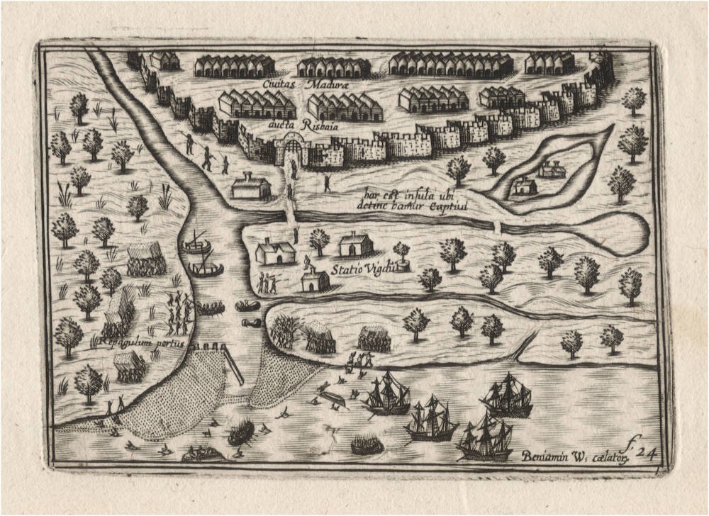
Civitas Madura ducta Risbaia [In map]
First Published
Amsterdam, 1601
This Edition
1649 first and only edition
Technique
Condition
mint
Price
This Item is Sold
Description
An excruciatingly rare miniature map/chart of the roadstead of Arosbaya on Madura Island, engraved ca 1601 by Benjamin Wright for Amsterdam publisher Cornelis Claesz, but not published at that time. This map only occurs in Claes Janszoon Visscher's exceptionally rare Tabularum Geographicarum Contractarum of 1649. It is the first time we see this map appear in the market, and the map (as well as the atlas) is lacking in every collection.
The map here is based on first hand observation and charting by the Dutch Second Fleet to the East Indies of 1598-1600. The map was originally engraved in 1601 or 1602, soon after the return of the last two ships of the second Dutch fleet to the East Indies, that had reached the spice islands of Ambon, Banda and Ternate/Tidore. Vice Admiral Wijbrant van Warwijck (1570-1615) was in Ternate from May 23 - August 19, 1599 with the ships Amsterdam and Utrecht. On his way to the spice islands, the Dutch tried to buy spices at the trading hub of Arosbaya, but to no avail. Forty of the Dutch crewe were taken hostage, and it took more than a month to negotiate a ransom for release of the crew.
The last ships of the fleet would be back in Amsterdam early September 1600. An extended journal of the voyage was published by Cornelis Claesz in 1601.
The map here was engraved by Benjamin Wright, shortly after the return of the fleet, when he still worked for Cornelis Claesz on a project for a miniature atlas. Interestingly, a similar version of this map is in an inset on Cornelis Claesz' ca 1602 wall map of Asia in eight sheets, which has a number of other insets based on the journal of the second fleet.
Condition
Paper color off-white/ivory with no restorations or imperfections. Wide margins all around. A dark and even impression of the copperplate, no sign of plate wear, especially for a copperplate that was over 50 years old when this imprint was made. On the contrary, the scratched support lines for the toponyms prove that these are first impressions from the plates, supporting Schilder's hypothesis that Wright was working on a miniature atlas project that was abandoned for unknown reasons. Blank on verso as called for. Pristine collector's condition.
The First and the Second Dutch Fleet to the East Indies
The dreams and labours of Petrus Plancius and Jan Huyghen van Linschoten culminated in the First Dutch Fleet to the East Indies which sailed on April 2, 1595 and returned on August 14, 1597. It was instrumental in the opening up of the Indonesian spice trade to the merchants that would soon form the United Dutch East India Company (VOC). This famous pioneering voyage, commanded by Cornelis de Houtman, would abruptly end the Portuguese Empire´s trade monopoly for the East and it would dramatically change the Indian Ocean theatre, notably the balance of power and the rules of trade. Right from this first voyage onward, the Dutch were going to dominate the East Indies and its trade for more than 200 years, and the Dutch were to stay in the area for more than 350 years.
Even though the First Fleet had not been as profitable as hoped, and only 94 of the original crew of 248 returned alive, it demonstrated that the Portuguese monopoly on the spice trade was over.
Within nine months, on May 1, 1598, a Second Fleet was dispatched, with a large fleet of eight ships, under command of Jacob van Neck, with Vice-Admiral Wybrand van Warwijck and famous Arctic explorer Jacob van Heemskerck as his lieutenants. Also aboard was Willem Jansz, who would discover Australia in 1606.
The fleet reached Bantam on November 25, 1598, where within one month four of the ships were filled with spices and sailed home under Jacob van Neck, reaching Amsterdam on July 19, 1599, less than 15 months of the departure and in half the time of the first fleet. The second voyage had been so quick that the Portuguese merchants living in Amsterdam did not believe that van Neck had been in the East Indies at all, they said that "the goods had been stolen half way".
When in Bantam, before van Neck sailed home, the General Council of the Fleet had decided that the other four ships under van Warwijck and van Heemskerck would sail east to find the spice islands of Ambon, Banda, and Ternate/Tidore.
The Dutch managed on their own to find all spice islands, to make trade treaties with the locals, and to establish trading posts there to buy spices for future fleets. This eliminated the need to buy spices from intermediate merchants in Bantam and elsewhere.
Heemskerck returned home in May 1600 from Ambon and Banda with two shiploads of nutmeg, while van Warwijck reached Amsterdam from Ternate in September 1600.
The expedition was considered a tremendous success, with a rich cargo of pepper, cloves, nutmeg, mace and cinnamon, netting a 400% profit for the investors. It would lead to the foundation of the Dutch East India Company (VOC) in 1602
Tabularum Geographicarum Contractarum
The map was issued in 1649 in the Tabularum Geographicarum Contractarum or Atlas Contractus by the distinguished Claes Janszoon Visscher (1587-1652). In this pocket atlas, all maps appear with a signature mark in the lower right. This particular map has f.24. Such numbers are intended for the bookbinder, to instruct where and in what order to bind the maps into the atlas. Signature marks were generally printed in typeset on the verso of maps, in addition to the page number. The reason is that the bookbinder works in terms of sections or gatherings, groups of paper sheets that need to be folded, and not in terms of page numbers. Because Visscher did not add any printed text to this atlas, leaving the verso of the maps blank, he chose to engrave the signature marks in the lower right corners of the maps.
In 1649 Visscher had come into possession of the original Langenes plates first used in 1598, which were originally owned by the Amsterdam publisher Cornelis Claesz, where Visscher had worked as a young apprentice. H. Laurentsz re-printed the atlas in 1609 and 1612, and the whereabouts of those copperplates is uncertain until they again appear in 1649. Apart from the old Langenes copperplates, Visscher adds a few new maps by himself, as well as a few unrecorded maps (like this one) that must have been made between 1599-1602 by Benjamin Wright when he (and Claes Janszoon Visscher) worked for Claesz.
The atlas is so rare that most of the maps in this final state are lacking in many important collections. Only 3 atlas copies are listed on WorldCat: British Library seems to be complete, State Library Victoria (Australia) almost complete, University of Michigan, 80 maps only.
Claes Janszoon Visscher was already at a respectable age when he issued the Atlas Contractus, but he knew the fifty years old maps by Langenes very well, because at a young age he had worked as an apprentice for Cornelis Claesz (c.1551-1609), who had been the stimulator and driving force of Dutch cartography, and who had been the publisher of the Langenes atlas.
It is possible that Visscher had already acquired the Langenes copperplates at the famous 1610 auction of the stock of books, maps, prints and copperplates of his former employer Cornelis Claesz. Never before had the Dutch Republic witnessed an auction of books and prints and copperplates of comparable scale.
According to Peter van der Krogt (New Koeman Volume III), no more than 8 copies of the atlas are known, of which only 6 are complete.
An unknown atlas project, engraved by Benjamin Wright
There are clear indications that around 1600 Cornelis Claesz was working not only on the miniature editions of Caert-Thresoor and the British Isles but also on another pocket atlas. This atlas was intended to show the coastlines, the mouths of the rivers, and the trading settlements that were important to Dutch merchants. At the same time, it was also meant to give information on the results of the voyages of discovery that the Dutch had made. Benjamin Wright carried out the task of engraving the maps from 1599 to 1602. These maps were not based on original work but were copies of existing maps and prints. For example, sections were taken from maps in Waghenaer's Thresoor (1592), which Claesz published from 1596 on. However, a selection was also made of maps and prints from journals of Dutch voyages that took place around 1600, material that Claesz had published in various languages.
It is not known why, in the end, the plans for this atlas were not carried out and the work was not completed. There are no explicit references to this project in Claesz's Const ende Caert-Register (1609). However, the fact that tens of copperplates had already been engraved in the time of Cornelis Claesz is substantiated by the existence of a miniature atlas that was published fifty years later. In 1649, Claes Jansz Visscher published a pocket atlas that is now extremely rare: N.J. Visscheri Tabularum Geographicarum Contractarum Libri Quatuor Denuò Recogniti. For this work, Visscher mainly used the copperplates that had been used in the various editions of the CaertThresoor, supplemented by new maps. But next to these, they also contain prints of maps that had been engraved by Benjamin Wright and that had not been used for the Caert-Thresoor.
Visscher's edition of 1649 gives grounds to try to reconstruct Cornelis Claesz's original plan for a separate pocket atlas. In that attempt, the sources used by the engraver Benjamin Wright should be traced as far as feasible. Though Wright was not an innovative engraver, he was a highly skilled craftsman who engraved numerous maps and prints for Cornelis Claesz in the years around 1600. After his Amsterdam period, he moved on to Italy, where he engraved mainly for Magini.
(Schilder)
References:
van der Krogt Koeman's Atlantes Neerlandici, Volume III, map 8150:341:54.
Schilder, Monumenta Cartographica Neerlandica, Volume VII, pp 484-488.
Benjamin Wright (1575-1613)
London, Amsterdam, Bologna and Rome.
Engraver and copperplate printer. Engraved a pair of celestial and terrestrial charts to illustrate John Blagrave, “Astrolabium uranicum generale" 1596;
Beschrijvinghe der zeecusten van Barbarielal tusken de straet van Gijbraltar ende caep de Cantin for Lucas Jansz. Waghenaer, “Thresoor der zee-vaert" 1596;
maps of Java, Sumatra, Madagascar and St. Helena for “Caert-thresoor, inhoudende de taflen des gantsche werelts landen” 1599, published by Cornelis Claesz of Amsterdam;
Gabriel Tatton, Nova et rece terraum et regnorum Californiae, Novae Hispaiae Californiae. Novae Hispaiae, Mexicanae, et Peruviae 1600;
Gabriel Tatton, Maris Pacifici quod Mar del Zur 1600; Hispaniae nova describtio 1600; Tabula geographica provinciarum Brabantiæ, Geldriæ comitatus, Sutphaniæ, Traiectini, Transilvaniæ, Drentiæ, Twentiæ, Hollandiæ, et Frisiæ; una cum præterlabentium fluviorum delineation 1600. for Cornelis Claesz;
Waerachtige af conterfeytinge der vermaẽr riviere van Londen, anders genaempt die Tamesis for Lucas Jansz. Waghenaer,
“Thresorie ou cabinet de la route marinesque" 1601;
Beschrijvinghe der landen ende zee-custen van Eembderlandt and eleven other charts for Lucas Jansz. Waghenaer, "Thresoor der zeevaert" 1602;
fourteen charts for Lucas Jansz. Waghenaer, "Den groten dobbelden nieuwen spieghel der zeevaert" 1603, again for Claesz;
a further thirty maps of the same size and style, including Alata castra Scotia regia urbs et metrolis vulgó Edimburgum ca. 1603 and Topographia insulæ Huenæ in celebri porthmo regna Daniæ were evidently engraved for Claesz at this time, but are extant only in Claes Jansz. Visscher, “Tabularum geographicarum contractarum libri quatuor denuo recogniti" 1649;
Italia nuova da Gio Antonio Magini 1608;
eleven maps for Magini's “Italia data in luce” 1620, the maps engraved somewhat earlier;
seven maps for Johann Isaac Pontanus, “Rerum et urbis Amstelodamensium historia” 1611, for Jodocus Hondius 1, again engraved at an earlier date, etc.
Said to have been born in 1575, and perhaps to be identified with the Benjamin Wright made free of the Goldsmiths' Company by patrimony 17 Mar 1597. Heawood suggested that the map Florentissimoru[m] Enorum Angliæ et Hiberniæ accurata descriptio veteribus et recentioribus nominibus illustrata 1594 might be by Wright, but Wright himself referred to his The armes of all the cheif corporations of England 1596 as the "first fruit of his labours”. He was working in Amsterdam by 1602 and probably for some years earlier, referred to in that year as an "Engelsch plaetsnyder woonende tot Amstelredam" [English copperplate cutter living in Amsterdam]. He subsequently worked in Bologna 1607-1608 and later Rome for the Italian publisher Giovanni Antonio Magini, who must have greatly valued Wright's work to have borne with so tiresome a collaborator, irregular in life and given to drink, for twice he had to release plates which Wright had pawned in Rome. Though other engravers known to have worked on Magini's “Atlas” ... it is surprising that no plates are signed but those bearing Wright's name” (Hind). John Evelyn bracketed Wright with Thomas Cecill as "little inferior to any we have enumerated for the excellency of their burins and their happy design”.
At the Hartshorne in Paternoster Row 1596, Amsterdam 1602, Bologna 1607-1608, Rome 1608-1613.
BBTI, BM. Burden (1996). COPAC. Goldsmiths. Griffiths. GL. Hind. Koeman. Shirley (2001). STC. Taylor (1954). Tooley.
(Worms and Baynton Williams)
Literature:
Laurence Worms and Ashley Baynton Williams, British Map Engravers, London, Rare Book Society, 2011, pp 735-736.
Valerie Scott, Tooley's Dictioonary of Mapmakers - Revised Edition Q-Z, Early World Press, 2004.
A.M. Hind, Engraving in England in the Sixteenth and Seventeenth Centuries. I, The Tudor Period, Cambridge University Press, 1952, pp 212-213.
Related Categories
Related Items


