Leen Helmink Antique Maps
Antique map of East Indies by Pierre Mortier

Stock number: 19823
Zoom ImageCartographer(s)
Pierre Mortier
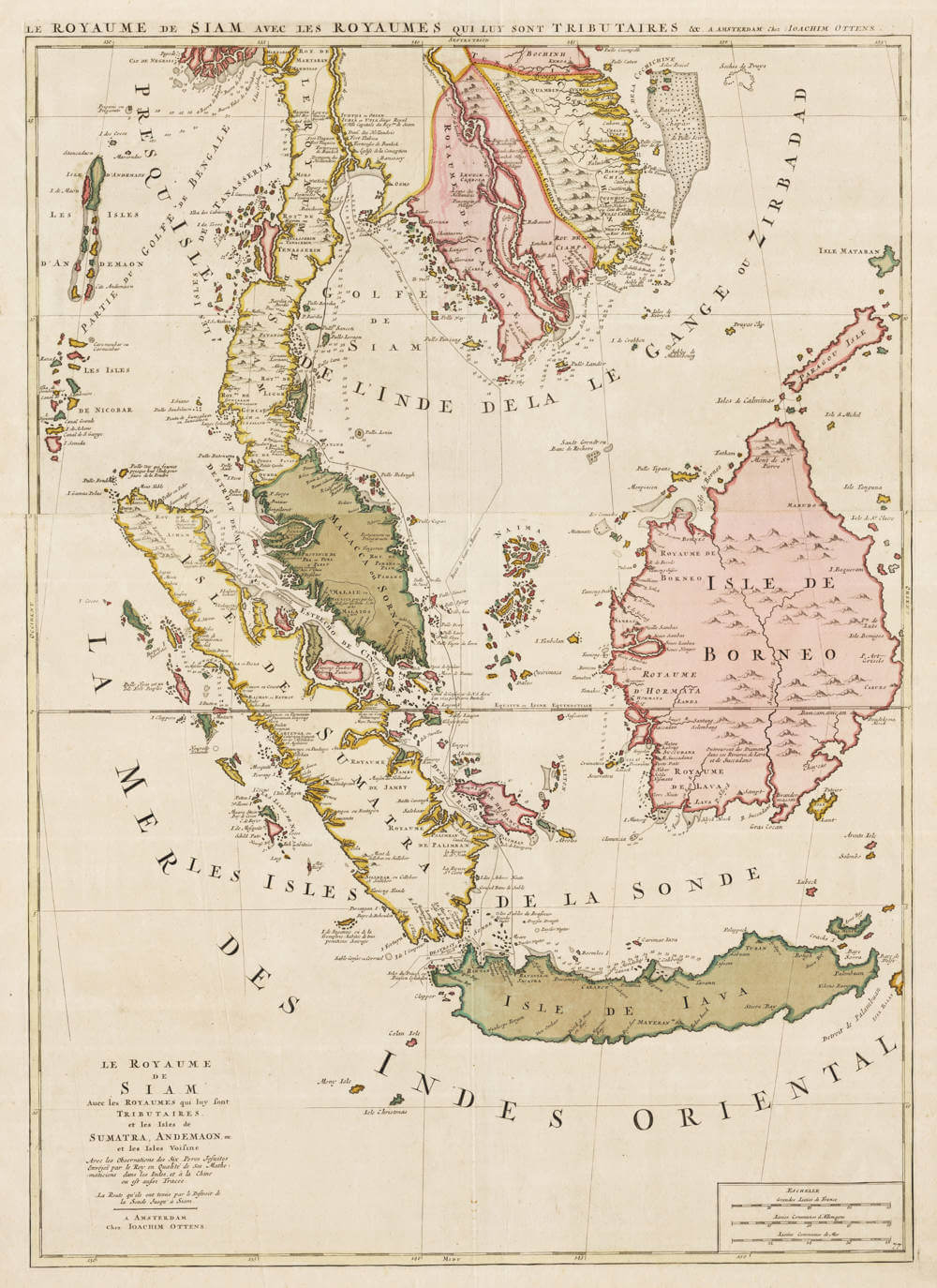
Title
Le Royaume de Siam avec les Royaumes qui luy sont Tributaires et les Isles de Sumatra, Andemaon, etc. et les Isles Voisine.
First Published
Amsterdam, 1692
This Edition
1740
Size
82.3 x 55.1 cms
Technique
Condition
excellent
Price
$ 2,250.00
(Convert price to other currencies)
Description
Gorgeous example of one of the most beautiful cartographic representations of Southeast Asia ever printed.
Early maps of Southeast Asia
Detailed, large-scale map of mainland Southeast Asia, Sumatra, Java, and Borneo, issued on two separate sheets.
The maps reflect knowledge gained from the French visits to Siam in the latter part of the seventeenth century.
The degree of detail is rare in maps of this area at this relatively early date. The overwhelming confusion in the course of the Mekong River would not be sorted out until the end of the nineteenth century.
(Suarez).
Pierre Mortier's oversized chart of Southeast Asia, published in his monumental three-part sea-atlas Le Neptune François. One of the most beautiful cartographic representations of Southeast Asia ever printed
The full French title translates as:
The Kingdom of Siam with the kingdoms that are tributary to it, and the islands of Sumatra, Andaman, etc., and the neighboring islands, with the observations of the six Jesuit Fathers sent by the King as his mathematicians to the Indies and to China, where is also traced the route that they took through the Strait of Sunda up to Siam.
This refers to scientific observations made by six French Jesuit missionaries (sent by Louis XIV in 1685). They traveled to Siam (and onward to China), making astronomical, geographical, and hydrographical notes along the way, including their ship's route via the Sunda Strait (between Java and Sumatra). The map often highlights trade routes, depth soundings, and political tributaries to the Siamese king.
These Jesuits were part of French diplomatic and scientific missions to the court of King Narai of Siam, led by figures like Father Guy Tachard. The data improved European mapping of the region significantly.
The chart has very detailed depiction of inland Thailand, with Bankok, Iudia (Siam, Ayutthaya) and Louvo (Lop Buri), the town where Siamese King Narai the Great resided eight months a year and where the French build a celestial observatory to accurately establish the longitude of Siam, by observation of the eclipse of the moon of December 11th, 1685. The King was an enthousiastic participant in this event.
The expedition was endowed with a veritable laboratory, including several large telescopes ranging in length from 12 to 80 foot.
King Narai the Great was very open to foreign contacts. modern science, and cross-cultural exchange. He received and sent many foreign embassies, the Kingdom effectively closed its doors to foreigners after King Narai's death in 1688, and the French records provide most of what is known about the region from that period.
The route track of the outbound and inbound voyage from Sunda and to Batavia is given in detail, with daily positions.
Rarity
From the maps issued by the Ottens publishing house, the maps signed and issued by founder Ioachim Ottens are exceptionally rare.
"The family business of print and map selling was founded by Joachim Ottens but the active period of map publishing was concentrated in the years between 1720 and 1750 when the brothers, Reiner and Joshua, produced enormous collections of maps, some as large as 15 volumes. These, including copies of practically all maps available at the time, were made up to order and were magnificently coloured."
(Moreland & Bannister).
Condition description
Excellent condition, stunning original colour. Two sheets joined. Second state of ca 1740, with the address of Joachim Ottens.
Related Categories
Related Items


