Leen Helmink Antique Maps
Antique map of Paraguay by Joan Blaeu

Stock number: 17130
Zoom ImageCartographer(s)
Joan Blaeu (biography)
Title
Paraquaria vulgo Paraguay cum adjacentibus
First Published
Amsterdam, 1658
This Edition
1662 Atlas Maior
Size
45.2 x 55.2 cms
Technique
Condition
mint
Price
$ 750.00
(Convert price to other currencies)
Description
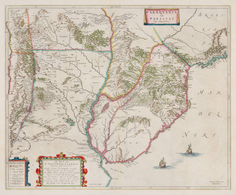
A magnificent and exceptionally rare copper-engraved map from Joan Blaeu’s monumental Atlas Maior, this superb chart presents one of the finest and most detailed early depictions of the Río de la Plata basin in South America. Focusing sharply on the region south of the 20th parallel, it encompasses present-day Paraguay, Uruguay, northern Argentina, and adjacent territories extending into southern Brazil, Bolivia, and Chile.
Drawn from the latest intelligence supplied by Jesuit missionaries active in the interior, the map offers a level of granularity far surpassing Willem Blaeu’s earlier, broader-scale work Paraguay, o Prov. de Rio de la Plata cum regionibus adiacentibus. It is celebrated as the first printed map to identify the Uruguay River by its modern name and provides an extraordinarily rich portrayal of the region’s intricate hydrography: the Paraguay, Paraná, and Uruguay river systems, together with numerous lakes (including the accurately rendered Lago de los Caracaras / Itatí Lagoon) and tributaries. Mountains and highlands rise pictorially, while dense forests evoke the lush South American interior. Settlements, missions, and towns are meticulously located throughout. A clear explanatory key in the lower left distinguishes indigenous villages from Spanish colonial cities (both extant and ruined), clerical schools, and both active and abandoned Jesuit and Franciscan missions — making the map an invaluable primary source for the study of 17th-century Jesuit reductions and the early colonial geography of the region.
The map is further enhanced by elegant decorative elements typical of the Dutch Golden Age: finely engraved sailing vessels (two Dutch ships) in the Atlantic, pictorial rendering of terrain, and elaborate strapwork cartouches. A Latin verse dedication in the lower-left cartouche honors Vincenzo Carafa (1585–1649), seventh Superior General of the Society of Jesus, underscoring the map’s close ties to Jesuit scholarship.
Engraved by the talented but short-lived Gerard Coeck (1608–1645), the plate first appeared around 1658 in a late edition of the Atlas Novus before taking its prominent place in the 1662 Atlas Maior (and subsequent editions).
Rarity
Following the disastrous 1672 fire that destroyed the Blaeu printing house, the plate appeared in only a handful of Blaeu atlases, original examples are genuinely rare and highly prized by collectors of South American cartography and Jesuit history.
Significance
A landmark of 17th-century cartography and a beautiful example of the Blaeu firm at the height of its powers, ideal for collectors of the Atlas Maior, South American exploration maps, or the history of the Jesuit missions in Paraguay.
Condition description
On a full sheet with very generous margins. With the finest contemporary hand coloring, typical of de-luxe Atlas Maior maps.
Willem Janszoon Blaeu (1571-1638)
Joan Blaeu (son) (1596-1673)
Cornelis Blaeu (son) (?-c.1642)
Willem Janszoon Blaeu died in October 1638, leaving his prospering business to his sons, Joan and Cornelis, who continued and expanded their father's ambitious plans.
After the premature death of his brother Cornelis in 1642, Joan directed the work alone and the whole atlas series of 6 volumes was eventually completed about 1655. As soon as it was finished he began the preparation of the even larger work, the Atlas Maior, which reached publication in 1662 in 11 volumes (later editions in 9-12 volumes) and contained nearly 600 double-page maps and 3,000 pages of text. This was, and indeed remains, the most magnificent work of its kind ever produced; perhaps its geographical content was not as up-to-date or as accurate as its author could have wished, but any deficiencies in that direction were more than compensated for by the fine engraving and colouring, the elaborate cartouches and pictorial and heraldic detail and especially the splendid calligraphy.
In 1672 a disastrous fire destroyed Blaeu's printing house in the Gravenstraat and a year afterwards Joan Blaeu died. The firm's surviving stocks of plates and maps were gradually dispersed, some of the plates being bought by F. de Wit and Schenk and Valck, before final closure in about 1695.
(Moreland and Bannister)


