Leen Helmink Antique Maps
Antique map of Brazil by Ruscelli

Stock number: 18858
Zoom ImageCartographer(s)
Girolamo Ruscelli (biography)
Title
Brasil Nuova Tavola
First Published
Venice, 1561
This Edition
1562 first state
Size
17.8 x 25.4 cms
Technique
Condition
excellent
Price
$ 450.00
(Convert price to other currencies)
Description
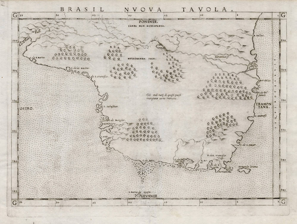
The first map of Brazil. First state, with the copperplate running off the top edge.
One of the modern maps from Girolamo Ruscelli's edition of Ptolemy's "La Geografia", first published in 1561 in Venice. Contrary to most of the other maps in Ruscelli's atlas, this map is not a copy of an earlier map by Gastaldi, but an original work by Ruscelli.
West is at the top as often with early maps of Brasil. In the upper left is de Rio de la Plata (River Plate), the Silver River. Some coastal placenames are given, but very little interior detail. An erupting volcano is shown in the Mullobamba Province, considered the source of the Amazon River, here named Marañón River. The river is so mighty, that it results in a sea of fresh water into the ocean (Mar dolce). Trees are depicted all over the map, to emphasize the lands are covered with dense forests and jungle. In the west it says "Terra non descoperta". A text refers to cannibalism: "Gli indi natij di questi paesi mangiano carne humana" (The Indians of these lands eat human meat).
"Though most of the maps in this atlas are enlarged re-engravings of those found in the Gastaldi edition of 1548, there are four new maps here. The new maps are important ones; they include the Zeno map of the northern regions, a Ptolemaic world map, and ones of Brasil and Tuscany."
(Martayan Lan).
Girolamo Ruscelli (1504-1566)
Girolamo Ruscelli (1504 Viterbo -1566 Venice), an Italian Alchemist, Physician and cartographer, was editor of a revised and expanded Italian edition of Ptolemy's 'Geographia', published as 'La Geografia di Claudio Tolomeo. The newly engraved maps were based, generally, on those compiled by Giacomo Gastaldi for the Venice miniature atlas edition of 1548.
Ruscelli's atlas was issued several times between 1561 and 1599 by the following publishers
- Venice, Vincenzo Valgrisi, 1561
- Venice, Vincenzo Valgrisi, 1562
- Venice, G. Zileti, 1564
- Venice, G. Zileti, 1574
- Venice, Heirs of Melchior Sessa, 1598-99
The Ruscelli and Gastaldi atlases were the most comprehensive atlases produced between Martin Waldseemüller's 'Geographia' of 1513, and Abraham Ortelius 'Theatrum' of 1570. The significance of the Gastaldi and Ruscelli atlases cannot be overestimated. They defined the known geography of the world for decades. These atlases also reintroduced the use of copper engraving into the service of cartography, which was dominated by woodcut printing after several not very succesful attempts to print from copper in the 15th century. The Gastaldi and Ruscelli atlases proved that maps could be beautifully engraved on copper. As it was a harder material than wood, it was harder to engrave but also gave the ability to render much more detail. The Gastaldi and Ruscelli atlases marked a turning point in the history of cartography, from then on the majority of cartographic works used this medium.
"Ruscelli was editor of a revised and expanded edition of Ptolemy's Geographia which was issued in Venice several times between 1561 and the end of the century.
The newly angraved maps were based, generally, on those compiled by Giacomo Gastaldi for the Venice edition of 1548."
(Moreland & Bannister).


