Leen Helmink Antique Maps
Antique map of Brazil by Joan Blaeu

Stock number: 18771
Zoom ImageCartographer(s)
Joan Blaeu (biography)
Title
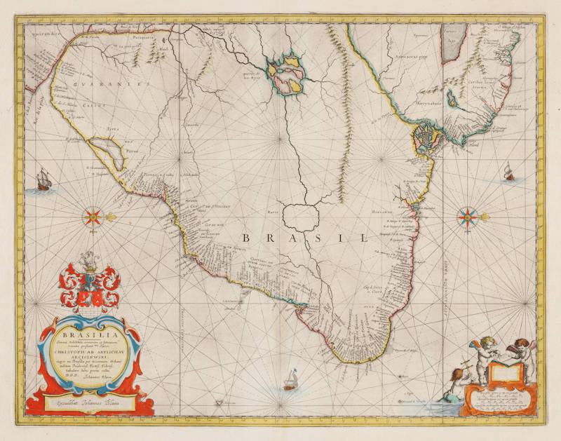
Brasilia
First Published
Amsterdam, 1642
This Edition
1663 Atlas Maior
Size
38.2 x 49.2 cms
Technique
Condition
excellent
Price
$ 1,250.00
(Convert price to other currencies)
Description
Blaeu's second map of Brazil. Coastline with many details, while inland highly conjectural and mostly empty. Oriented with west at the top.
"Oriented west to the top of the plate, this general map of Brazil was an early product of Joan Blaeu himself, made after he had assumed full control of the publishing house following the death of his father a few years before.
This plate was made to replace the de Laet derivative which Willem had acquired from the Hondius plate stock in 1629 and is considerably more detailed than its older namesake. At the time of the first appearance of the map in 1642, the Dutch were actively attempting to colonise the north-eastern coastal regions of Brazil. Dutch attempts to found an empire in South America began in 1624 with an attack on Bahia (Salvador), the natural harbour at Bahia de Todos os Santos. The attack was unsuccessful, and the [ Netherlands West India Company ] made another, succesful, attempt in 1630, this time at Olinda de Pernambuco (Recife) farther north near the north-easternmost point of Brazil.
At the height of their power in Brazil, when the Dutch controlled or influenced four of the seven Portuguese 'capitaniás' (or governorships) in Brazil under the leadership of Johan Maurits van Nassau-Siegen, much of the trade of north-eastern Brazil was in the hands of the Netherlands West India Company acting on the assumption that it had the right to trade - and make war - with Spain and Portugal in the Americas.
However, the Dutch never quite succeeded in bringing the Portuguese colonists in the region under their control. Johan Maurits, during his governorship which lasted from 1637 to 1644, never ceased to warn his superiors in The Netherlands that unless they sent out Protestant settlers from The Netherlands, or Germany, or Scandinavia, to replace the Roman Catholic Portuguese settlers, the latter would always remain Portuguese at heart, and would ultimately revolt against the Dutch at the earliest opportunity. Johan Maurits' fears came to pass in 1645, and in the Luso-Dutch war which followed, many senior Dutch officials who had married Portuguese wives, turned their allegiance towards João IV of Portugal, leading to the final expulsion of the Dutch from Brazil in 1654."
(Goss).
Willem Janszoon Blaeu (1571-1638)
Joan Blaeu (son) (1596-1673)
Cornelis Blaeu (son) (?-c.1642)
Willem Janszoon Blaeu died in October 1638, leaving his prospering business to his sons, Joan and Cornelis, who continued and expanded their father's ambitious plans.
After the premature death of his brother Cornelis in 1642, Joan directed the work alone and the whole atlas series of 6 volumes was eventually completed about 1655. As soon as it was finished he began the preparation of the even larger work, the Atlas Maior, which reached publication in 1662 in 11 volumes (later editions in 9-12 volumes) and contained nearly 600 double-page maps and 3,000 pages of text. This was, and indeed remains, the most magnificent work of its kind ever produced; perhaps its geographical content was not as up-to-date or as accurate as its author could have wished, but any deficiencies in that direction were more than compensated for by the fine engraving and colouring, the elaborate cartouches and pictorial and heraldic detail and especially the splendid calligraphy.
In 1672 a disastrous fire destroyed Blaeu's printing house in the Gravenstraat and a year afterwards Joan Blaeu died. The firm's surviving stocks of plates and maps were gradually dispersed, some of the plates being bought by F. de Wit and Schenk and Valck, before final closure in about 1695.
(Moreland and Bannister)


