Leen Helmink Antique Maps
Antique map of El Dorado by Jodocus Hondius

Stock number: 18872
Zoom ImageTitle
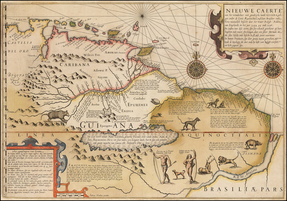
NIEUWE CAERTE van het wonderbaer ende goudrijcke landt GUIANA, gelegen onder de Linie Æquinoctiael
First Published
Amsterdam, 1598
This Edition
1598 separate issue
Size
35 x 52 cms
Technique
Condition
margins short, overall excellent
Price
This Item is Coming Soon
Description
The ultimate map of humankind's biggest legend of treasure, the quest for El Dorado, the place of immeasurable wealth. Inca tales of mountains of solid gold and silver would lead Sir Walter Raleigh and many early European discoverers to their doom.
This map by Hondius was published as a loose sheet and is of exceptional rarity. One of only a handful of copies have survived the centuries. There is no copy in the US or North America.
El Dorado (Spanish for "the golden one"), originally El Hombre Dorado ("The Golden Man") or El Rey Dorado ("The Golden King"), was the term used by the Spanish Empire to describe a mythical tribal chief (zipa) of the Muisca people, an indigenous people of the Altiplano Cundiboyacense of Colombia, who, as an initiation rite, covered himself with gold dust and submerged in Lake Guatavita. The legends surrounding El Dorado changed over time, as it went from being a man, to a city, to a kingdom, and then finally to an empire. A second location for El Dorado was inferred from rumors, which inspired several unsuccessful expeditions in the late 1500s in search of a city called Manõa on the shores of Lake Parime. Two of the most famous of these expeditions were led by Sir Walter Raleigh, the first in 1595 and the second in 1617.
In pursuit of the legend, Spanish conquistadors and numerous others searched what is today Colombia, Venezuela, and parts of Guyana and northern Brazil, for the city and its fabulous king. In the course of these explorations, much of northern South America, including the Amazon River, was mapped. By the beginning of the 19th century, most people dismissed the existence of the city as a myth.
This Hondius map is based on the discoveries of Sir Walter Raleigh's 1595 first quest for the legendary treasure city of Manaos or El Dorado. In 1594, Raleigh had come into possession of a Spanish account of a great golden city at the headwaters of the Caroní River. A year later, he explored what is now Guyana and eastern Venezuela in search of Lake Parime and Manoa, the legendary city. Once back in England, he published 'The Discovery of Guiana' (1596), an account of his voyage which made exaggerated claims as to what had been discovered.
A simple scrollwork cartouche in the upper right corner contains the Dutch map title, which reads translated:
'New map of the wondrous land, full of gold, [called] Guiana, located below the Equator, between Brazil and Peru: off-late visited by Sir Water [!] Ralegh Knight of England, in the years 1594.95 and 1596. The coasts of this map have been diligently drawn on their latitudes and proper distances, by a certain ship's mate who has sailed along them and visited them in the previously noted years. The interior provinces have been extracted under great difficulty, from both booklets, which have been published by and on order of the aforementioned Ralegh'.
As we can ascertain from the title, Jodocus Hondius derived his knowledge of the coastline of Guiana from the draft version of a map that he had obtained from a ship's officer. The bosun on Captain Keymis's ship was selling plottes of dicoveryes after returning from Guiana in 1596. Hondius, who had spent ten years in London and still had many connections there, was apparently able to acquire one. He based his knowledge of the interior on Walter Raleigh's 'Discoverie' and Captain Keymis's 'Relation'. Besides these original editions, Hondius might also have used the Dutch translations published in Amsterdam by Cornelis Claesz, in 1598.
The system of compass lines is limited to the area offshore and does not extend into the landmass so as not to disrupt the carefully balanced drawing of the interior. The fact that Hondius never saw the manuscript map of Guiana that is preserved in the British Library is also clear from names he gave to the rivers. He filled in the hinterland, of which he actually knew nothing, with imaginary stories and drawings.
Another scrollwork cartouche in the lower left corner of the map contains some interesting additional notes, here in translation:
Certain properties of Guiana.
'In Guiana winter falls between May and September, during which period it is impossible to remain there with ships: because then tremendous storms, thunder, lightning and increased water levels prevail. Because of which the Orinoco River [table] increases by 30 feet and all islands in the estuary become submerged, causing the inhabitants to vacate them for hills and trees, on which they build their dwellings. The Arwaccas tribe is a nomad people and mostly friends to the Spaniards. The Jaos tribe is very powerful and outspoken enemies of the Spaniard. They paint their bodies, which allows to distinguish them from the Arwaccas. The principal trade items, which may be obtained here, are gold, precious stones, pearls, balm-oil, long peppers, oil of juniper, sugar, incense, precious medicinal herbs, gums, honey, silk, cotton and brazil-wood. The principal wares, that are sought here, are axes, machetes and similar commodities, also low-quality linens'.
In the interior, creatures and legends occupy the space between the watersheds of the Orinoco and the Amazon. A large inland sea occupies a central position. “This Lake is called Parime by the Cannibal Nation; and by the other laos Nation, Foponowini. It is a body of salt water, 200 leagues long; herein are many islands and a large number of Canoes, or rather Indian boats'. This lake, surrounded by mountains to the west and south, lies in the middle of a separate province bearing the name GUIANA, which is indicated in color on our facsimile edition. On the northern shore lies ‘Manoa or El Dorado, said to be the largest city that one finds in the whole world'. References to gold are found in the northern mountain range and the Cassipa lacus: 'Iwarawakeri. hese rocks are mostly of goldmines. In the sand of the rivers around this lake Cassipa is also much gold'. The text also refers unabashedly to the population: 'Iwaipanoma. In this province, as S. Raleigh writes, the people have no heads, are very strong and cruel'.
At the mouth of the Orinoco, a nautical warning appears along one of the tributaries (Capuri R.): ‘Capury R. runs into the River Orinoco but is very shallow and full of sand banks. At low tide it is no more than five feet in depth. It lies in a bay where the eastern wind blows so fiercely that one would not think it was possible to sail out of it again'.
A legend along the Essequibo (R. Essekebe ofte Devorita) describes the journey made by the natives to the Parime Lake: 'The surrounding nations of this river travel in 20 days from the mouth of the same to a day's journey from the great lake Parime. From where they for the first time take their provisions on their backs and carry them overland to the lake, afterwards they come for their canoes and carry them overland too, to the salt lake, to do their trade there. Ordinarily, the Spaniards do not come any farther than this River Essekebe'.
Other routes of navigation are described too: 'The inhabitants of this River Wiapogo travel in 20 days with their canoes from the mouth of this river to the lake that Manoa lies on'.
It was assumed that this city could also be reached by way of the Cayenne River:
‘Cayenne is a very beautiful river and ample enough to enter with many ships. At the beginning, or the mouth, it is about a German mile wide; there are 3 rocks in the mouth, so that it also has 3 streambeds. The nations in the surroundings are very rich in victuals and goods to trade with. One believes for certain that this R[iver] gives one access to the large lake and the large city of Manoa, rich with gold'
The map image depicts various animals (e.g., a tiger, leopard, lion, wild boar, armadillo, turtle, hare, and deer). As Hondius reports, ‘All of the animals that we have shown here can be found in Guiana along with much more that is good to eat, as well as many fowl, partridges, pheasants, cranes, quackelen, herons, and many other kinds of birds”.
But Hondius also gives a graphic rendition of Walter Raleigh's fantastic descriptions, as in the drawing of the Iwaipanoma Indian, who is drawn without a head and with eyes between the shoulders, and as in the depiction of an Amazon. Of course, this map could not omit a lengthy quotation from Raleigh's tantalizing story about these Amazons: ‘Amazons, from whom the Amazon River takes its name, is a Nation consisting exclusively of women. These women do not spend more than one month a year with the men; as far as we can say, this is the month of April. In this month they meet with the surrounding Kings and Queens of these Amazons, which have the first choice. Afterwards, each chooses a lot for one's company. In this month they enjoy themselves greatly together with dancing and jumping, eating, drinking, according to their custom. Afterwards, each one returns to one's land. The women who later bear a son, send the same to the father; who has a daughter, raise her and send a present to the father. These Amazons are very cruel and bloodthirsty toward their enemies. They have much gold, which they obtain in exchange for certain green stones. This is described by Sir Water [sic] Ralegh’.
There is no doubt that Raleigh and Keymis's exaggerated descriptions of the riches of Guiana influenced Dutch merchants. These stories, visually supported by Hondius's map, induced Dutch traders to embark on voyages of trade to the 'wild coasť, as the Dutch called the area between the Orinoco and the Amazon.
Jodocus Hondius's map of Guiana was used as a model for two contemporary collections of travel accounts. As an illustration of Raleigh's story, a copy of Hondius's map is included in the eighth volume of Théodore de Bry's Grands Voyages (Frankfurt am Main, 1599). A proof state of the map is extant on which most of the longer texts are not yet incorporated. In the definitive version, the text in both cartouches differs from Hondius's text, though most of the legends were adopted from his map and included in a German translation. Hondius's map is mentioned on the title page of travel accounts compiled by Levinus Hulsius (Nürnberg, 1599).
(Schilder)
Jodocus Hondius (1563-1612)
Jodocus Hondius the Younger (son) (1594-1629)
Henricus Hondius (son) (1597-1651)
Jodocus Hondius the Elder, one of the most notable engravers of his time, is known for his work in association with many of the cartographers and publishers prominent at the end of the sixteenth and the beginning of the seventeenth century.
A native of Flanders, he grew up in Ghent, apprenticed as an instrument and globe maker and map engraver. In 1584, to escape the religious troubles sweeping the Low Countries at that time, he fled to London where he spent some years before finally settling in Amsterdam about 1593. In the London period he came into contact with the leading scientists and geographers of the day and engraved maps in The Mariner's Mirrour, the English edition of Waghenaer's Sea Atlas, as well as others with Pieter van den Keere, his brother-in-law. No doubt his temporary exile in London stood him in good stead, earning him an international reputation, for it could have been no accident that Speed chose Hondius to engrave the plates for the maps in The Theatre of the Empire of Great Britaine in the years between 1605 and 1610.
In 1604 Hondius bought the plates of Mercator's Atlas which, in spite of its excellence, had not competed successfully with the continuing demand for the Ortelius Theatrum Orbis Terrarum. To meet this competition Hondius added about 40 maps to Mercator's original number and from 1606 published enlarged editions in many languages, still under Mercator's name but with his own name as publisher. These atlases have become known as the Mercator/ Hondius series. The following year the maps were re-engraved in miniature form and issued as a pocket Atlas Minor.
After the death of Jodocus Hondius the Elder in 1612, work on the two atlases, folio and miniature, was carried on by his widow and sons, Jodocus II and Henricus, and eventually in conjunction with Jan Jansson in Amsterdam. In all, from 1606 onwards, nearly 50 editions with increasing numbers of maps with texts in the main European languages were printed.
(Moreland and Bannister)
Sir Walter Raleigh (c. 1552 or 1554 - 1618)
Sir Walter Raleigh, also spelled Ralegh, was an English landed gentleman, writer, poet, soldier, politician, courtier, spy and explorer. He was cousin to Sir Richard Grenville and younger half-brother of Sir Humphrey Gilbert. He is also well known for popularising tobacco in England. Raleigh was one of the most notable figures of the Elizabethan era.
Raleigh was born to a Protestant family in Devon, the son of Walter Raleigh and Catherine Champernowne. Little is known of his early life, though in his late teens he spent some time in France taking part in the religious civil wars. In his 20s he took part in the suppression of rebellion in Ireland participating in the Siege of Smerwick. Later, he became a landlord of property confiscated from the native Irish. He rose rapidly in the favour of Queen Elizabeth I and was knighted in 1585. Raleigh was instrumental in the English colonisation of North America and was granted a royal patent to explore Virginia, paving the way for future English settlements. In 1591, he secretly married Elizabeth Throckmorton, one of the Queen's ladies-in-waiting, without the Queen's permission, for which he and his wife were sent to the Tower of London. After his release, they retired to his estate at Sherborne, Dorset.
In 1594, Raleigh heard of a "City of Gold" in South America and sailed to find it, publishing an exaggerated account of his experiences in a book that contributed to the legend of "El Dorado". After Queen Elizabeth died in 1603, Raleigh was again imprisoned in the Tower, this time for being involved in the Main Plot against King James I, who was not favourably disposed towards him. In 1616, he was released to lead a second expedition in search of El Dorado. During the expedition, men led by his top commander ransacked a Spanish outpost, in violation of both the terms of his pardon and the 1604 peace treaty with Spain. Raleigh returned to England and, to appease the Spanish, he was arrested and executed in 1618.
(Wikipedia)


