Leen Helmink Antique Maps
Antique map of America by Münster
The item below has been sold, but if you enter your email address we will notify you in case we have another example that is not yet listed or as soon as we receive another example.

Stock number: 18801
Zoom ImageDescription
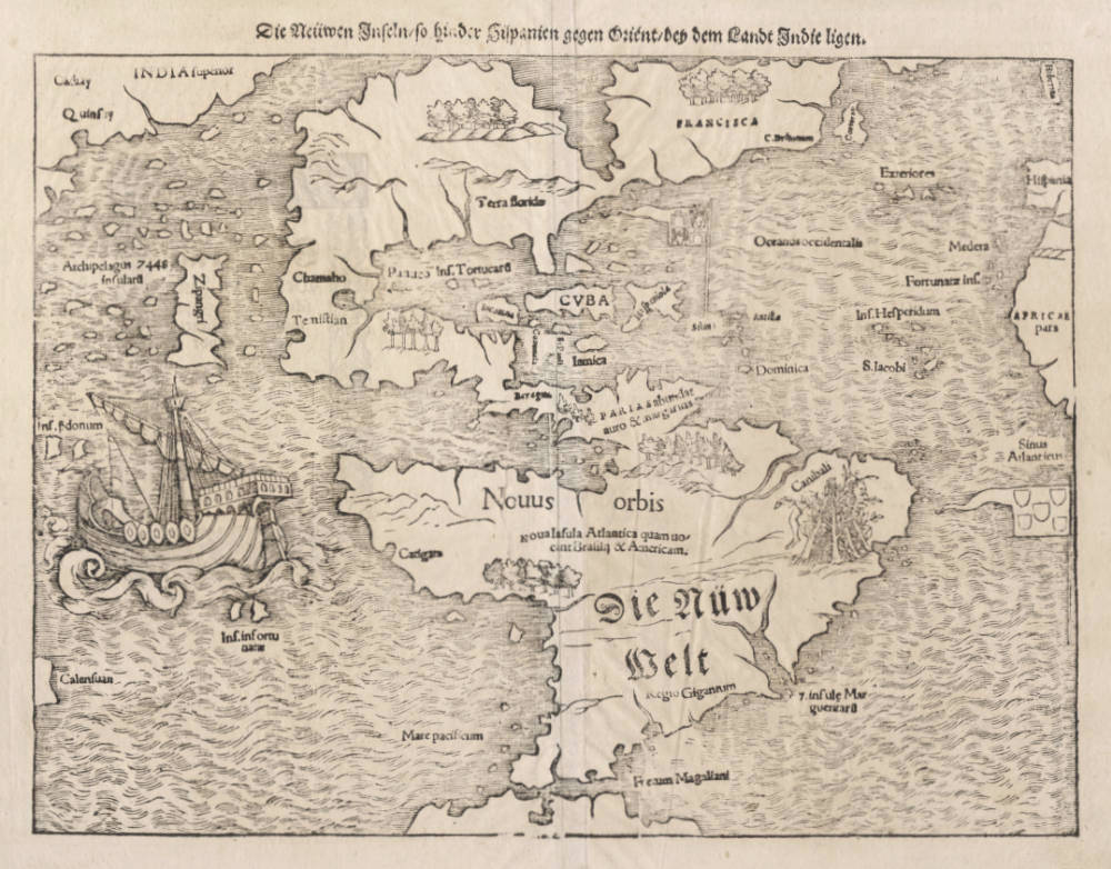
The first map of America as a continent, and a seminal map to any America collection. The map is a first in many ways and was widely disseminated in the 16th century and sealed the name America, perpetuating Martin Waldseemüllers erroneous belief that Amerigo Vespucci had discovered the New World, instead of Columbus. Even though Waldseemüller tried to correct his error, the name America would stick, also because it fit so well with the names of the other continents Europa, Africa and Asia.
The map was published in many editions from 1540 until 1578, after which is was replaced by a different map modeled on the newer 1570 map by Ortelius. 13 different states have been identified, mainly differing in the insert letter types for place names.
"Sebastian Münster's famous woodblock of the New World. The map shows North America almost split by the Sea of Verrazano, Japan is entitled Zipangri, and it is the first to show North and South America together."
(Potter p135).
"In 1540 Sebastian Münster, who was to become one of the most influential cartographers in the sixteenth century, published his edition of Ptolemy's Geographia with a further section of modern, more up-to-date maps. He included for the first time a set of continental maps, the America was the earliest of any note. Münster studied Hebrew at Heidelberg and was a scholar of geography, writing amongst other works the Polyhistor. He was one of the first to create space in the woodblock for the insertion of place names in metal type. The map's inclusion in Münster's Cosmographia, first published in 1544, sealed the fate of 'America' as the name for the New World. The book proved to be very popular, there being nearly forty editions during the following 100 years.
The Portuguese flag is shown flying over the South Atlantic and the Spanish one over her possessions in the Caribbean. The Strait of Magellan are named again, and Mare pacificum appears for the first time on a printed map. Magellan's ship Victoria, the only survivor of five vessels, appears in the middle of this ocean.
Marco Polo's influence can be seen with Zipangri (Japan) appearing three years before the earliest known contact with Europeans, and also his Archipelagus 7448 insularu. The Yucatan is still shown as an island and the lake at Temistitan (Mexico City) is depicted emptying into the Gulf of Mexico.
North America is not shown as accurately as the southern half of the continent, it had to a large extent been neglected so far by explorers. When Giovanni di Verrazano, in the service of Francis I of France, passed by the outer banks of the Carolinas in 1524 he mistook Pamlico and Albemarle Sounds for the 'Oriental Sea' that led to Cathay and the rich Spice Islands. Here Münster perpetuates this error and through the success of this book provided a huge impetus to the exploration of the region. The only plane names occurring here are C.Britonum, marking England's early explorations, Corterati, probably Newfoundland after the Corte Reals, and Terra florida. FRANSISCA is named in honour of Francis I."
(Burden).
Condition
Early state of the woodblock from the 1550 German edition of the Cosmographia, state 5 (of 13). A strong and even imprint of the woodblock. Paper mildly mellow, as usual when not cleaned or washed, with a very authentic look and feel. No paper restorations or imperfections. Ample margins all around. A very attractive example for collectors.
Sebastian Münster (1489-1552)
Following the various editions of Waldseemüller's maps, the names of three cartographers dominate the sixteenth century: Mercator, Ortelius and Münster, and of these three Münster probably had the widest influence in spreading geographical knowledge throughout Europe in the middle years of the century.
His Cosmographia, issued in 1544, contained not only the latest maps and views of many well-known cities, but included an encyclopaedic amount of detail about the known - and unknown - world and undoubtedly must have been one of the most widely read books of its time, going through nearly forty editions in six languages.
An eminent German mathematician and linguist, Münster became Professor of Hebrew at Heidelberg and later at Basle, where he settled in 1529. In 1528, following his first mapping of Germany, he appealed to German scholars to send him "descriptions, so that all Germany with its villages, towns, trades, etc. may be seen as in a mirror", even going so far as to give instructions on how they should "map" their own localities. The response was far greater than expected and such information was sent by foreigners as well as Germans so that, eventually, he was able to include many up-to-date, if not very accurate, maps in his atlases.
He was the first to provide a separate map of each of the four known Continents and the first separately printed map of England. His maps, printed from woodblocks, are now greatly valued by collectors. His two major works, the Geographia and the Cosmographia were published in Basle by his step-son, Henri Petri, who continued to issue many editions after Münster's death of the plague in 1552.
(Moreland & Bannister).
The remaining modern maps, [...], are all drawn on a plane projection, undergraduated, without scales, and variously oriented with north, south, east or west at the top, "without the excuse of topographical necessity", as Nordenskjöld severely remarks. In spite of these and other cartographic defects, they constitute an important corpus of geographical knowledge and interpretation; Münster was the first atlas-maker to furnish separate maps of the four continents then known; and for England, Scandinavia and southern Germany, eastern Europe and America he brought recent and significant representations into general currency.
(Skelton).
The Cosmographia of Sebastian Münster must rank as the greatest geographical compendium of the period - an immensely detailed work illustrated with woodcut portraits, scenes, town plans and panoramas, and maps. Born in 1488, Münster was a Fransiscan who became Professor of Hebrew at Heidelberg and later at Basle, where he taught Hebrew and, amongst other works, published the first German translation of the Bible from Hebrew. In 1540 his edition of Ptolemy's Geographia was published, followed in 1544 by the Cosmographia Universalis. Together these ran to over 35 editions published mostly in Basle in Latin, German, French and Italian versions. Münster's particular cartographic importance lies in the number of 'new' maps he introduced and, above all, in the innovative, separate mapping of each of the four continents. The map of the Americas is not only the first map to show the Western Hemisphere separately, but is also the first to show North and South America joined together.
(Potter p38).
Sebastian Münster was raised as a Franciscan monk, converted to Lutheranism, taught Hebrew at Heidelberg and Basle, and was proficient in Greek and some Asian tongues. He died of the plague in 1552. First published in 1540, his atlas was the first to contain separate maps of each of the four continents.
(Suárez).
In 1540 Sebastian Münster, who was to become one of the most influential cartographers in the sixteenth century, published his edition of Ptolemy's Geographia with a further section of modern, more up-to-date maps. He included for the first time a set of continental maps, the America was the earliest of any note. Münster studied Hebrew at Heidelberg and was a scholar of geography, writing amongst other works the Polyhistor.
He was one of the first to create space in the woodblock for the insertion of place-names in metal type. The map's inclusion in Münster's Cosmography, first published in 1544, sealed the fate of "America" as the name for the New World. The book proved to be very popular, there being nearly forty editions during the following 100 years.
(Burden).


