Leen Helmink Antique Maps
Antique map of the Pacific by van der Aa

Stock number: 18798
Zoom ImageCartographer(s)
Pieter van der Aa (biography)
Title
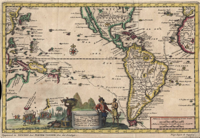
Scheeps-Togt door Ferdinand Magellaan
First Published
Leiden, 1706
This Edition
1706 or later
Size
15.5 x 22.0 cms
Technique
Condition
excellent
Price
$ 750.00
(Convert price to other currencies)
Description
Important and decorative map illustrating the epic first circumnavigation of the world by Ferdinand Magellan from 1519-1522. The map shows the track from Sanlucar de Barrameda, through the strait that bears his name, the crossing of the Pacific and the landfalls in the Far East.
The map has a very spectacular cartouche with the great explorer himself, natives from South America and the Philippines. The scene in the lower left depicts his death at the hands of Mactan warriors near Cebu.
A globe, Jacob's staff and a compass are in the foreground.
Pieter van der Aa (1659-1733)
Records show that van der Aa, born in Leiden in 1659, made an early start in life by being apprenticed to a bookseller at the age of nine and starting his own in business as a book publisher by the time he was twenty-three.
During the following fifty years he published an enormous amount of material including atlases and illustrated works in every shape and size, two of them consisting of no less than 27 and 28 volumes containing over 3,000 maps and plates.
(Moreland & Bannister).
Related Categories
Antique maps of the World
Antique maps of the East India Company
Antique maps of Australia
Antique maps of the Philippines
Antique maps of the United States
Antique maps of South America
Antique maps of Central America
Antique maps of North America
Antique maps of Canada
Antique maps of America
Old books, maps and prints by Pieter van der Aa


