Leen Helmink Antique Maps
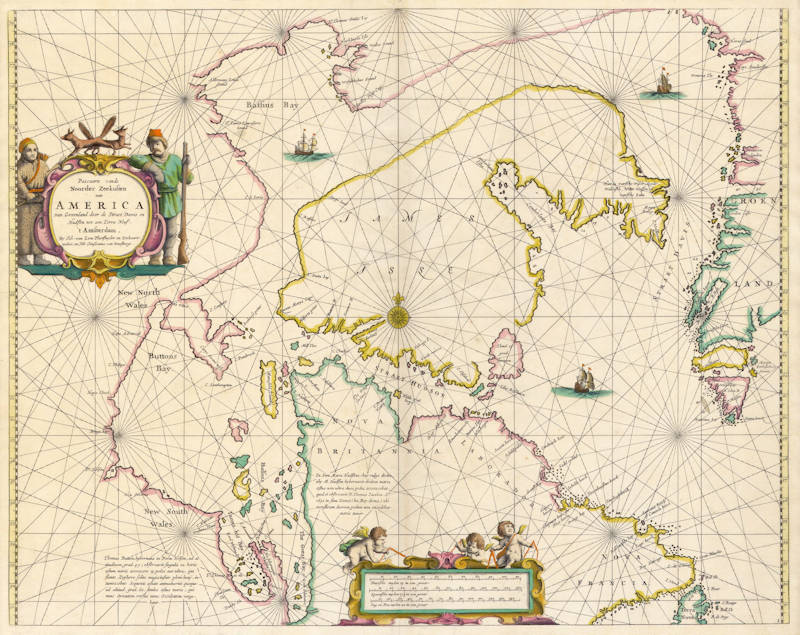
Antique map of Hudson Bay by van Loon

Stock number: 18767
Zoom ImageCartographer(s)
Johannes van Loon (biography)
Title
Pascaarte vande Noorder Zeekusten van America
First Published
Amsterdam, 1666
This Edition
1668
Size
43.3 x 55.0 cms
Technique
Condition
excellent
Price
$ 5,500.00
(Convert price to other currencies)
Description
Johannes van Loon's very rare sea chart of the Northern part of America, with Hudson Bay, Davis Straits, Button Bay and the North West Passage. The first sea chart of the region. All charts by Joannes van Loon's Sea Atlas are of exceptional rarity.
"This particularly uncommon chart of the approaches to Hudson Bay and the North West Passage was a progenitor. In the same year, 1666, Pieter Goos published his 'Zee Atlas' which includes a virtually identical chart. It has not been proved which appeared first, but it is believed that the van Loon most probably takes pride of place. This is because his atlas was the most innovative of the two while Goos largely drew upon existing charts."
(Burden 394)
Johannes van Loon (1611-1686)
Joannes van Loon was an accomplished mathematician and astronomer. His first cartographic involvements were with Theunis Jacobsz during the 1640s. From 1650 he worked with Joannes Janssonius, engraving amongst other worksthe plates for his Celestial Atlas by Cellarius, 1660.
In 1661 he published his first work with his brother, Gillis; the 'Zee Atlas' contained thirty-five maps. In 1666 the plates were Jan Jansson van Waesberge, with whom he then co-published the atlas. This edition was expanded to forty-seven maps, and by 1676 there were fifty.
(Burden)


