Leen Helmink Antique Maps
Antique map of Ascension Island by Linschoten

Stock number: 19437
Zoom ImageCartographer(s)
Jan Huygen van Linschoten (biography)
Title
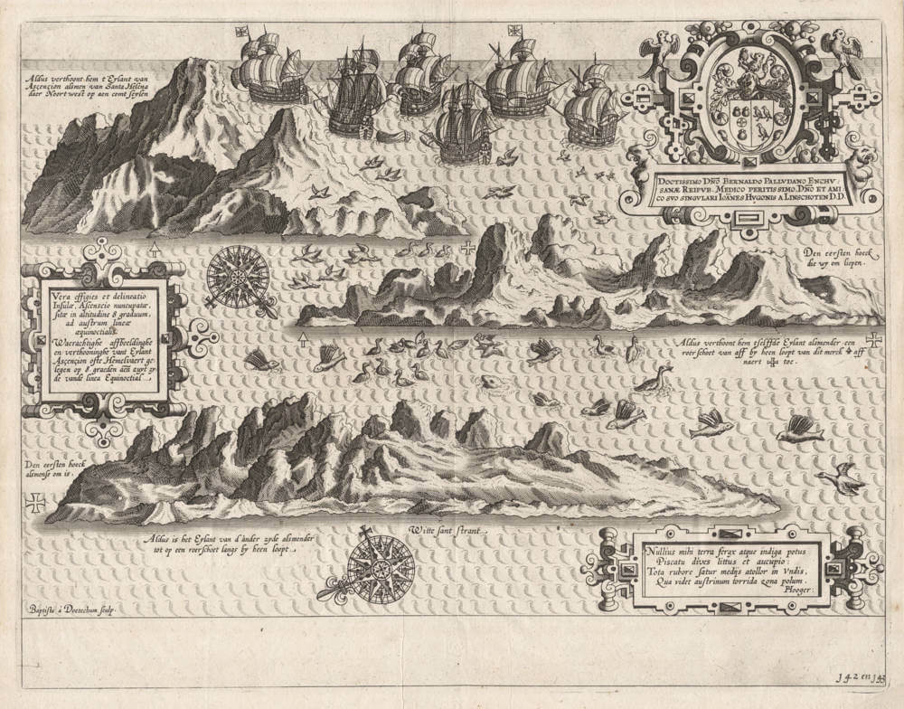
Vera effigies et delineatio Insulae, Ascencio ...
First Published
Amsterdam, 1596
Size
26.2 x 34.0 cms
Technique
Condition
excellent
Price
$ 550.00
(Convert price to other currencies)
Description
Linschoten's spectacular bird eye's views of Ascensiun Island, from his Itinerario.
At the top of the engraving we see a detailed image of the Portuguese return fleet of 1598 from Goa on its way to Lisbon, with van Linschoten on board.
The engraving is signed by Baptista van Doetecum, one of the foremost engravers of the day. It is made after drawings made from life by Linschoten himself, who was a careful observer and documented everything he learned from his years in Portuguese India and the sailing route to and from there.
The views show the island from three different sides, "when sailing around it at a gun shot's distance". The upper left depiction is how it appears when sailing towards it sailing Northwest coming from the Island of Saint Helena.
The print is embellished with three elaborate strapwork cartouches. Many flying fish are depicted.
Ascencion Island History of Discovery
The island's discovery is disputed. An undocumented claim states that it was discovered in 1501, either on 25 March or 21 May, by João da Nova, on his outward voyage to India. It is claimed that he named it Ilha de Nossa Señora de Conceiçao ("The Island of Our Lady of the Conception") or "Conception Island". However, there is no documentary evidence of his discovery. It was discovered or re-discovered in 1503 on the Ascension Day (which fell on Thursday, 21 May 1503, of that year) , (11 may 1503 julian calendar) by Alphonse de Albuquerque and named (or renamed) Ilha da Ascensão after this feast day. This discovery was documented by Albuquerque.
Dry and barren, the island had little appeal for passing ships except for collecting fresh meat, and was not claimed for the Portuguese Crown. Mariners could hunt for the numerous seabirds and the enormous female green turtles that laid their eggs on the sandy beaches. The Portuguese also introduced goats as a potential source of meat for future mariners.
In February 1701, HMS Roebuck, commanded by William Dampier, sank in the common anchoring spot in Clarence Bay to the northwest of the island. Sixty men survived for two months until they were rescued. Almost certainly, after a few days they found the strong water spring in the high interior of the island, in what is now called Breakneck Valley (there is a much smaller water source, lower on the mountain, which was named Dampier's Drip by people who probably misinterpreted Dampier's story).
(Wikipedia)
Jan Huygen van Linschoten (1563-1610)
Jan Huyghen van Linschoten, a Dutchman born in Delft, was secretary to the Portuguese Archbishop in Goa between 1583 and 1589. These experiences were recorded in the Itinerario, which was first published in Dutch (Amsterdam: 1595-1596), and contains the most comprehensive account of the East and West Indies available at the end of the sixteenth century. As well as including important travel accounts from contemporary Portuguese, Dutch and Spanish sources, it is the first work to include precise sailing instructions for the Indies and also includes an account of America.
The Itinerario provided detailed practical information on how to get to and carry on the trade with America and India. The work was indispensible to sailors on the route to the Indies; it provided a dictionary of exotic commodities, of national trading methods, etc. Linschoten’s work, along with Hakluyt’s, served as a direct stimulus to the building of the vast English and Dutch overseas empires. Legend has it that copies were given to every ship sailing to India to use as a log-book, as is confirmed in many surviving ship's journals.
Monumenta Cartographica Neerlandica VII - Jan Huygen van Linschoten and his Itinerario
For the publication of Van Linschoten's Itinerario, Cornelis Claesz did not settle for the thirty-six illustrations that had been exquisitely engraved by the Van Doetecum family. The publisher felt he should spare no expense to make the 'heerlijck werck' [masterly piece], as he called it, as accessible as possible to the readership interested in geography. Therefore, he had a number of 'nette, perfecte caerten' [beautiful and perfect maps] made for his own account. Besides a world map, five detail maps were included in the Itinerario and the Beschryvinghe. The world map is the map by Petrus Plancius that had already been engraved in 1594 by Joannes van Doetecum Jr. and published by Cornelis Claesz. But in some copies of the 1596-99 editions of the Itinerario, this map was replaced by another world map. The substitution was arranged in co-operation with the Antwerp publisher Joan Baptista Vrients and the replacement map was engraved by the Van Langren brothers.
The five detailed maps of Van Linschoten's Itinerario, all of which were engraved by Arnold Floris and Hendrik Floris van Langren, cover a large proportion of the non-European world known at the time. According to the map titles, these detail maps were composed with the aid of the best Portuguese and Spanish charts and rutters. These maps clearly reveal the influence of the set of maps that Cornelis Claesz had already published previously (1592-94), for which Petrus Plancius was responsible. Plancius's maps were copied for inclusion into Van Linschoten's work. These copies differ only in minor details from the originals.
(Günter Schilder)
Antique Maps - A Collector's Guide
Van Linschoten, born in Haarlem, is heard of in the service of the Portuguese Archbishop of Goa where he spent five years between 1583 and 1588.
On his return to Holland he produced a History of his travels, important for the inclusion of maps from Portuguese sources, at that time rarely available to Dutch – or any other – cartographers. The maps (including a world map by Petrus Plancius) engraved by van Langren, are highly decorative with large cartouches, the arms of Portugal, compass roses, rhumb lines and sea monsters. Some are illustrated with views of prominent places or islands.
(Moreland and Bannister)


