Leen Helmink Antique Maps
Antique chart of Rottnest Island with an inset view of the Swan River
The item below has been sold, but if you enter your email address we will notify you in case we have another example that is not yet listed or as soon as we receive another example.

Stock number: 19325
Zoom ImageCartographer(s)
Title
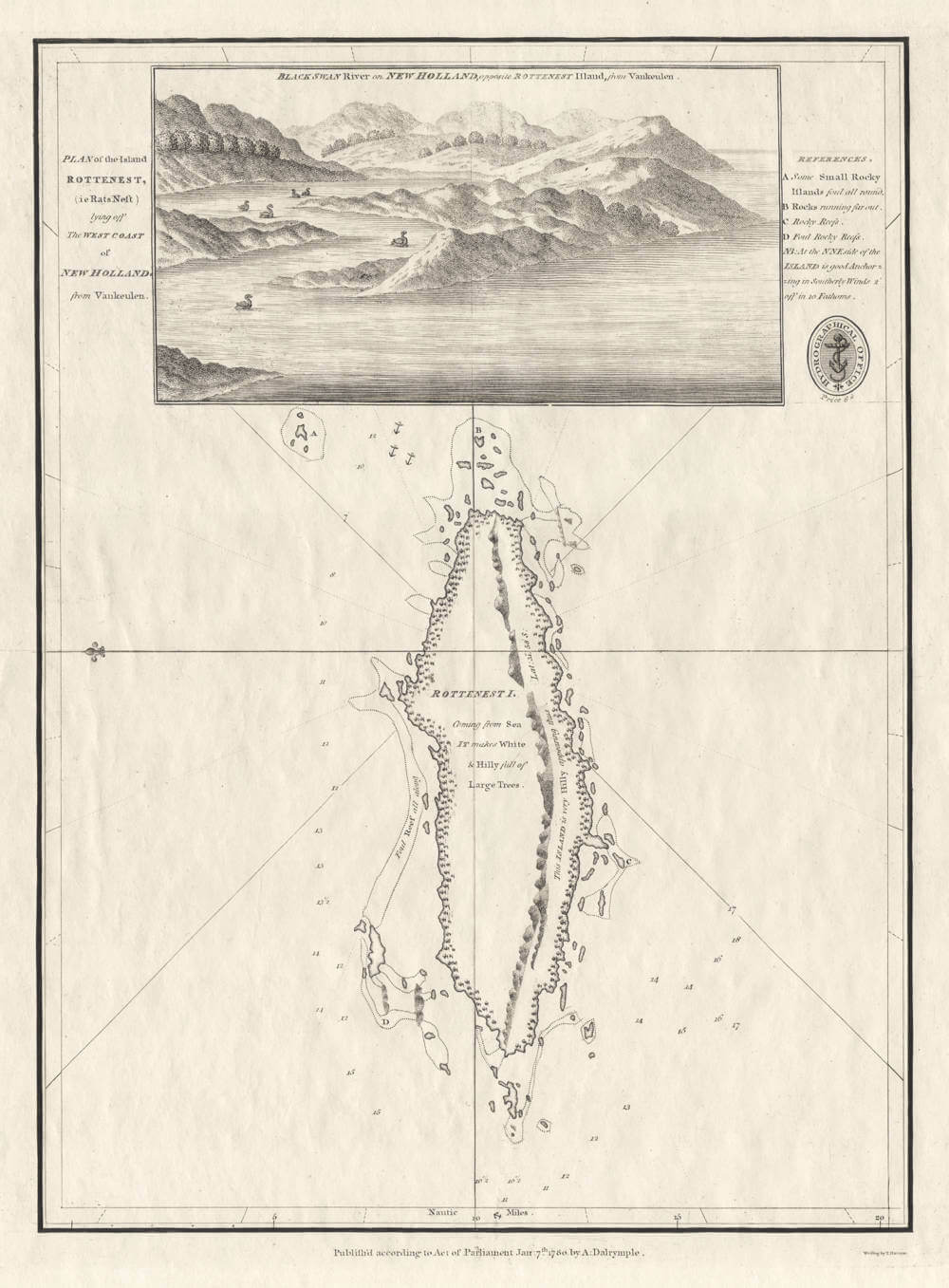
Plan of the Island Rottenest
First Published
London, 1780
This Edition
London, 1832
Size
29.0 x 21.0 cms
Technique
Condition
excellent
Price
This Item is Sold
Description
A Cartographical Icon of Australian History
Alexander Dalrymple’s Chart of Rottnest Island, with an inset view of the Swan River estuary, after van Keulen's 1753 chart of Western Australia, based on Willem de Vlaming's explorations of 1696/97. De Vlaming's original manuscript chart in two sheets has survived and is now in the National Library of Australia.
The map is of utmost rarity, it is the first time we have found one and we have not been able to find any auction records of it.
First published in 1780, the example here is the second state from the 1832 restrike with the seal of the Admiralty added in the upper right. The Admiralty also issued a limited-edition restrike of this chart, from the original copper plate but on modern paper, in 1979, to commemorate the 150th anniversary of the foundation of the Swan River Colony in 1829.
PLAN of the Island ROTTENEST, (ie Rats Nest) lying off the WEST COAST of NEW HOLLAND, from Vankeulen.
BLACK SWAN River on NEW HOLLAND, opposite ROTTENEST Island, from VanKeulen.
Publish;d according to an Act of Parliament Jan:7th.1780 by A:Dalrymple.
Copper engraving, printed on paper, 29.0 x 21.0 cm.
Alexander Dalrymple was Hydrographer to the English East India Company, and first Director of the newly formed Hydrographical Department of the Admiralty in 1795. Although an excellent hydrographer, he was rather opinionated and clashed with Captain Cook over the latter's appointment, a position that Dalrymple believed belonged to him. This map is based on Van Keulen's 1753 chart of the Western Australian coastline. Rottnest Island is shown on the same sheet as an illustration of the mouth of the Swan River, also adapted from Van Keulen, from a copper plate that had first been published in 1726 by François Valentijn.
Alexander-Dalrymple (1737-1808)
Alexander Dalrymple FRS (24 July 1737 – 19 June 1808) was a Scottish geographer and the first Hydrographer of the British Admiralty. He was the main proponent of the theory that there existed a vast undiscovered continent in the South Pacific, Terra Australis Incognita. He produced thousands of nautical charts, mapping a remarkable number of seas and oceans for the first time, and contributing significantly to the safety of shipping. His theories prompted a number of expeditions in search of this mythical land, until James Cook's second journey (1772–1775) led to the conclusion that, if it did exist, it was further south than the 65° line of latitude South.
Dalrymple was born at Newhailes, near Edinburgh, the eleventh of fifteen children of Sir James Dalrymple and his wife, Lady Christian Hamilton, the daughter of the Earl of Haddington.
He went to London in 1752 and was appointed a writer in the British East India Company, being first posted to Madras. He arrived in Madras in 1753. While with the East India Company he became interested in the possibilities of trade with the East Indies and China, and subsequently negotiated a treaty with the sultan of Sulu and visited Canton (Guangzhou) at age 22. He was elected Provisional Deputy Governor by the Manila Council with the departure of Dawsonne Drake on 29 March 1764. He then departed Manila 10 April for Sulu with Sultan Alimuddin I.
In 1765 he returned to London where was elected a fellow of the Royal Society. There he became acquainted with the civil engineer John Smeaton, who during the course of his studies on windmills had devised a descriptive scale for grading wind speed. This scale was included in the paper for which he was awarded the Copley Medal.[citation needed] In Defining the Wind: The Beaufort Scale and How a 19th-Century Admiral Turned Science into Poetry, author Scott Huler relates that Dalrymple's voyages had convinced him that a standard scale for measuring the speed of wind at sea would be of great value to sailors, and that he had included Smeaton's scale in his work Practical Navigation, which was written around 1790 but never published. It is believed that Dalrymple conveyed this information to Francis Beaufort, who later refined the wind scale that bears his name and that is still in use today.
Whilst translating some Spanish documents captured in the British occupation of Manila in 1762, Dalrymple had found Luis Váez de Torres' testimony proving a passage south of New Guinea now known as Torres Strait. This discovery led Dalrymple to publish the Historical Collection of the Several Voyages and Discoveries in the South Pacific Ocean in 1770–1771, which aroused widespread interest in his claim of the existence of an unknown continent . Meanwhile, James Cook had been appointed in his place to lead an expedition to the South Pacific which in 1770 discovered the east coast of Australia.
In 1772 Dalrymple published his first set of charts, four of which were of the seas around Sulu. In 1779, he headed the hydrographic office of the East India Company, and that of the Admiralty in 1795. He remained Hydrographer of the Royal Navy until his death in 1808.
In 1782 he was elected a foreign member of the Royal Swedish Academy of Sciences.
In 1820, he was honoured when a Scottish surgeon and botanist William Roxburgh, first published the genus name Dalrympelea to a group of flowering shrubs from Tropical Asia.
(Wikipedia)
Johannes van Keulen (1654-1711)
Gerard van Keulen (son) (1678-c.1727)
Johannes van Keulen II (grandson) (active 1726-1755)
The Dutch produced a remarkable number of enterprising and prolific map and chart makers but not even the Blaeu and Jansson establishments could rival the vigour of the van Keulen family whose business was founded in 1680 and continued under their name until 1823 and in other names until 1885 when it was from wound up and the stock dispersed at auction.
Throughout the history of the family, the widows several of the van Keulens played a major part, after their husbands' deaths, in maintaining the continuity of the business. The firm was founded by Johannes van Keulen who was registered as a bookseller in Amsterdam in 1678. In 1680 he published the first part of his 'Zee Atlas' which, over the years, was expanded to 5 volumes and continued in one form or another until 1734. More ambitious and with a far longer and more complicated life was his book of sea charts, the 'Zee-Fakkel', first published in 1681–82, which was still being printed round the year 1800. A major influence in the development of the firm was the acquisition in 1693 of the stock of a rival map publisher, Hendrik Doncker.
Although the firm was founded by Johannes van Keulen, he was primarily a publisher; it was his son, Gerard, a talented engraver, mathematician, Hydrographer to the East India Company, who became mainspring of the business which not only published charts but also books on every aspect of geograpy, navigation and nautical matters,
(Moreland and Bannister)
It was grandson Johannes van Keulen (II) who in 1753 produced Volume VI of the Zee-Fakkel for the VOC East Indiamen, containing printed charts for the navigation covering the waters from the Cape of Good Hope to Nagasaki . The atlas was not commercially sold and only for use on board of VOC ships, therefore it is also refered to as the 'secret atlas' odf the VOC. The engraving quality and craftmanship surpasses that of all earlier printed sea charts.
Sea charts from the secret atlas are among the rarest and most desirable sea charts for collectors.
Willem de Vlamingh 1640-c.1698
Willem Hesselsz de Vlamingh (November 1640 – c. 1698) was a Dutch sea captain who explored the central west coast of New Holland (Australia) in the late 17th century, where he landed in what is now Perth on the Swan River. The mission proved fruitless, but he charted parts of the continent's western coast.
Willem de Vlamingh was born in Oost-Vlieland in the Dutch Republic. He was baptised on 28 November 1640. In 1664, de Vlamingh sailed to Novaya Zemlya and discovered Jelmerland. In 1668, he married; his profession was skipper in whaling, and he still lived on the island Vlieland. In 1687, he and his wife sold their "apartment" in the Jordaan.
De Vlamingh joined the Dutch East India Company (VOC) in 1688, and made his first voyage to Batavia in the same year. Following a second voyage, in 1694, he was asked, on request of Nicolaes Witsen, to mount an expedition to search for the Ridderschap van Holland, a VOC capital ship that was lost with 325 passengers and crew on its way to Batavia in 1694. VOC officials believed it might have run aground on the western coast of Australia.
In 1696, de Vlamingh commanded the rescue mission to Australia's west coast to look for survivors of the Ridderschap van Holland that had gone missing two years earlier, and had admiral Sir James Couper on board. There were three ships under his command: the frigate Geelvink, captained by de Vlamingh himself; the Nijptang, under Captain Gerrit Collaert; and the galiot Weseltje, under Captain Cornelis de Vlamingh, son of Willem de Vlamingh. The expedition departed Texel 'strictly incognito' on 3 May 1696 and, because of the Nine Years' War with France, sailed around the coast of Scotland to Tristan da Cunha. In early September the three ships arrived at Cape of Good Hope, where they stayed for seven weeks because of scurvy among the crew. There, Cornelis de Vlamingh took command after Laurens T. Zeeman died. On 27 October, they left using the Brouwer Route on the Indian Ocean route from the African Cape of Good Hope to the Dutch East Indies. On their way east they checked Île Saint-Paul and Île Amsterdam, but no wreckage or survivors were found. On 5 December they sailed on.
On 29 December 1696, de Vlamingh's party landed on Rottnest Island. He saw numerous quokkas (a native marsupial), and thinking they were large rats he named it 't Eylandt 't Rottenest ("Rats' Nest Island"). He afterwards wrote of it in his journal: "I had great pleasure in admiring this island, which is very attractive, and where it seems to me that nature has denied nothing to make it pleasurable beyond all islands I have ever seen, being very well provided for man's well-being, with timber, stone, and lime for building him houses, only lacking ploughmen to fill these fine plains. There is plentiful salt, and the coast is full of fish. Birds make themselves heard with pleasant song in these scented groves. So I believe that of the many people who seek to make themselves happy, there are many who would scorn the fortunes of our country for the choice of this one here, which would seem a paradise on earth".
On 10 January 1697, he ventured up the Swan River. He and his crew are believed to have been the first Europeans to do so. They are also assumed to be the first Europeans to see black swans,[10] and de Vlamingh named the Swan River (Zwaanenrivier in Dutch) after the large number they observed there. The crew split into three parties, hoping to catch an Aborigine, but about five days later they gave up their quest to catch a "South lander".
On 22 January, they sailed through the Geelvink Channel. The next days they saw ten naked, black people. On 24 January they passed Red Bluff. Near Wittecarra they went looking for fresh water. On 4 February 1697, he landed at Dirk Hartog Island, Western Australia, and replaced the pewter plate left by Dirk Hartog in 1616 with a new one that bore a record of both of the Dutch sea-captains' visits. The original plate is preserved in the Rijksmuseum in Amsterdam.
de Vlamingh, with his son and Collaert, commanded a return fleet from the Indies on 3 or 11 February 1698, which arrived in his hometown, Amsterdam, on 16 August. However, it is not certain that de Vlamingh was still alive at that point, and burial records from Vlieland around this time do not exist. On an earlier retourship, de Vlamingh had sent Witsen a box with seashells, fruits and vegetation from New Holland (Australia), as well as eleven drawings that Victor Victorsz had made on the expedition. De Vlamingh also included some black swans, but they died on the voyage. Witsen offered the drawings to Martin Lister. Witsen, who had invested in the journey, was disappointed the men had been more interested in setting up trade than in exploring. In 1699, William Dampier would explore the coast of Australia and New Guinea.
(Wikipedia)
Related Categories
Related Items


