Leen Helmink Antique Maps
Antique sea chart of Western Australia by Johannes van Keulen
The item below has been sold, but if you enter your email address we will notify you in case we have another example that is not yet listed or as soon as we receive another example.

Stock number: 17673
Zoom ImageTitle
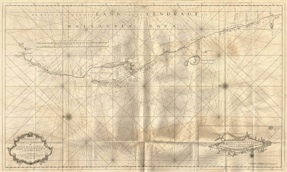
Het Westelykste Gedeelte van 't Land vande Eendragt, of Nova Hollandia
First Published
Amsterdam, 1753
Size
58.5 x 99.0 cms
Technique
Condition
excellent
Price
This Item is Sold
Description
Johannes (II) van Keulen's large 1753 sea chart of Western Australia, based on Willem de Vlaming's explorations of 1696/97. De Vlaming's original manuscript chart in two sheets has survived and is now in the National Library of Australia.
Printed on thick and heavy double-layer paper, intended for use a sea. A strong impression of the copperplate. White paper. Good margins. A superb example of the best available early map of Western Australia.
A Cartographical Icon of Australian History
Johannes van Keulen’s Chart of Western Australia, 1753
Het Westelyckste Gedeelte | van ‘T LAND vande EENDRAGT, | of | NOVA HOLLANDIA. |
Strekkende van het Eyland Rottenest tot | voorby de Willems Rivier.
Te AMSTERDAM | by JOANNES VAN KEULEN, Boek- en Zee- | Caart verkooper op de hoek
van de | Nieuwe-brug-steeg.
[The westernmost part of the Land of the Eendracht or Nova Hollandia. Extending from the
island of Rottnest, to past the Willems river. At Amsterdam at Joannes van Keulen’s book and
sea-chart seller at the corner of Nieuwebrugsteeg].
Copper engraving, printed on paper, 58.5 x 99 cm. With latitude graduation: 32º20’S - 21ºS.
Two scale bars, scale c. 1: 150.000. North to the left.
Inset of Rottnest Island, 14 x 29 cm (but by mistake the compass rose in the inset is oriented upside down, pointing south instead of north).
After Tasman’s voyages (1642/43 and 1644) Dutch ships made landfalls on the coast of New Holland in the seventeenth century only by accident. There was, however, one exception: the expedition by Willem de Vlamingh in 1696/97, which was actually planned. This was the last great Dutch voyage of discovery to New Holland and provided new information about the west coast, parts of which had scarcely been explored. A large outline chart in the National States Archives in The Hague and in 1970 rediscovered watercolour paintings of the coastal profiles (now in the Maritime Museum in Rotterdam) provide an accurate comprehensive view of New Holland’s west coast from Rottnest Island to the North West Cape.
At the end of December 1696 De Vlamingh’s fleet sighted Rottnest Island. In the following days the Swan River area was explored, and on 13 January the fleet coasted up to the North West Cape for the next five weeks. Several landings were made along the monotonous and inhospitable coast in an attempt to make contact with the Aboriginals, but these failed.
At Dirk Hartog Island they found the pewter plate left in 1616 by Dirck Hartog to immortalize his visit with the ship Eendracht to this coast for posterity (now in the Rijksmuseum collection in Amsterdam). This is the oldest monument of European provenance on Australian soil. To commemorate his own visit, De Vlamingh himself left a pewter plate at the same spot (now in the Western Australian Museum collection in Fremantle). The name Cape Inscription recalls the story of the two memorial plates. The De Vlamingh plate reminds us of the great journey of De Vlamingh whose mapping and exploration made such a decisive contribution in the development of knowledge of the western coast of New Holland.
The cartographical results of De Vlamingh’s voyage did not achieve a wide circulation. A surprising feature of cartographic design of around 1700 and later is that De Vlamingh’s voyage of discovery is reflected only on a few manuscript charts. In those days, people were satisfied with the representations of results from the period of Tasman and his predecessors. De Vlamingh’s journey was filed in the VOC archives and more than fifty years went by before De Vlamingh’s results were given a wider publicity.
After the death of Isaak de Graaf in 1743, the post of mapmaker of the East India Company fell into the hands of the Van Keulen family, starting with Johannes van Keulen (1743-1755). In 1753 the sixth part of the Zee-Fakkel (Sea-torch) appeared, which shows the coasts, islands and ports of the VOC-area for the first time in print. This atlas was compiled by Jan de Marre, ‘examiner in navigation to the Dutch East India Company’, and published by Johannes van Keulen, ‘chart-maker to the same Company’. Up to this time any information about the coasts and waters of the territories covered by the charter of the VOC had been issued to the ships almost exclusively in the shape of manuscript charts in order to guarantee a measure of secrecy of navigational information. The printed edition of volume 6 of the Zee-Fakkel meant that the Dutch navigational knowledge was now made available to other nations.
This publication was a milestone in maritime cartography of the Asiatic waters. The sixth volume of the Zee-Fakkel provides a good example of the extent of the Dutch knowledge of the Asian waters around 1750. From 1754 onward, each departing VOC ship was carrying a copy on board. Concerning the Australian waters, the last chart in this volume is of great importance. This is a huge chart of the West-Australian coast, the first printed chart to refer to Willem de Vlamingh’s achievements, which now become accessible to a wider public. The execution of the chart suggests that this is not a slavish copy of De Vlamingh’s outline-chart, even if it has indisputably served as its model. The chart shows the entire coast from the Swan River to North- West Cape. From the journal Jan de Marre selected a number of descriptions of the land which he skillfully included in the representation of the coastline: the result being an easily accessible detailed chart. On Dirk Hartog Island the drawing to ‘Dirk Hartogs Reede’ (Dirk Hartog’s Roadstead) is shown and the reference ‘Aan dit kruys heeft men een Tinne Schotel gevonden’ (at this cross a pewter plate was found). This is the reference to the pewter plate left by the Eendracht under command of Dirk Hartog in 1616.
Attention has also to be paid to the drawing of the Houtman Abrolhos of Zeewyks Droogte. The ship Zeewijck of the VOC-Chamber Zeeland under command of Jan Steyns was wrecked on the rocks of Half Moon Reef on 9th June 1727. The survivors landed at the nearby Gun Island. Eventually they succeeded to build a sloop to carry all the castaways to Batavia.
This Van Keulen chart was of great importance to the French explorations, as is demonstrated by the ‘Etat des cartes et plans remis au Capitaine Baudin pour son voyage par le Dépôt Général de la Marine’. On the list of the ‘cartes et plans manuscits’ there was, as nr. 1, the ‘Carte de la côte occidentale d’Endracht à la Nouvelle Hollande, copiée d’une carte hollandaise, 2 exemplaires’. No doubt these are manuscript copies of the printed Van Keulen chart; this suspicion is confirmed by a ‘Traduction de la carte hollandaise de la côte occidentale de la Nouvelle Hollande’, which was also issued to Baudin, a five-page list sets out the Dutch names of the Van Keulen chart with their French equivalents.
Literature:
C. Koeman, The sea on paper. The story of the Van Keulens and their ‘Sea-torch’. Amsterdam: Theatrum
Orbis Terrarum N.V., 1972. Introduction to the facsimile edition.
C. Koeman, Atlantes Neerlandici. Amsterdam: Theatrum Orbis Terrarum Ltd. 1970,Vol. IV.
G. Schilder, Voyage to the Great South Land. Willem de Vlamingh 1696-1697. Sydney: Royal Australian
Historical Society, 1985.
G. Schilder, The Southland Explored. The voyage by Willem Hesselsz. de Vlamingh in 1696-97, with the
coastal profiles and a chart of Western Australia in full-size colour reproduction. Alphen aan den Rijn:
Uitgeverij Canaletto, 1984.
G. Schilder and Hans Kok, Sailing fort he East. History and Catalogue of Manuscript Charts on vellum of
the Dutch East India Company (VOC), 1601-1799. Houten: Hes & De Graaf Publishers, 2010.
D. de Vries [et al.], The Van Keulen Cartography. Amsterdam 1680-1885. Alphen aan den Rijn:
Canaletto / Repro Holland, 2005.
Johannes van Keulen (1654-1711)
Gerard van Keulen (son) (1678-c.1727)
Johannes van Keulen II (grandson) (active 1726-1755)
The Dutch produced a remarkable number of enterprising and prolific map and chart makers but not even the Blaeu and Jansson establishments could rival the vigour of the van Keulen family whose business was founded in 1680 and continued under their name until 1823 and in other names until 1885 when it was from wound up and the stock dispersed at auction.
Throughout the history of the family, the widows several of the van Keulens played a major part, after their husbands' deaths, in maintaining the continuity of the business. The firm was founded by Johannes van Keulen who was registered as a bookseller in Amsterdam in 1678. In 1680 he published the first part of his 'Zee Atlas' which, over the years, was expanded to 5 volumes and continued in one form or another until 1734. More ambitious and with a far longer and more complicated life was his book of sea charts, the 'Zee-Fakkel', first published in 1681–82, which was still being printed round the year 1800. A major influence in the development of the firm was the acquisition in 1693 of the stock of a rival map publisher, Hendrik Doncker.
Although the firm was founded by Johannes van Keulen, he was primarily a publisher; it was his son, Gerard, a talented engraver, mathematician, Hydrographer to the East India Company, who became mainspring of the business which not only published charts but also books on every aspect of geograpy, navigation and nautical matters,
(Moreland and Bannister)
It was grandson Johannes van Keulen (II) who in 1753 produced Volume VI of the Zee-Fakkel for the VOC East Indiamen, containing printed charts for the navigation covering the waters from the Cape of Good Hope to Nagasaki . The atlas was not commercially sold and only for use on board of VOC ships, therefore it is also refered to as the 'secret atlas' odf the VOC. The engraving quality and craftmanship surpasses that of all earlier printed sea charts.
Sea charts from the secret atlas are among the rarest and most desirable sea charts for collectors.
Willem de Vlamingh 1640-c.1698
Willem Hesselsz de Vlamingh (November 1640 – c. 1698) was a Dutch sea captain who explored the central west coast of New Holland (Australia) in the late 17th century, where he landed in what is now Perth on the Swan River. The mission proved fruitless, but he charted parts of the continent's western coast.
Willem de Vlamingh was born in Oost-Vlieland in the Dutch Republic. He was baptised on 28 November 1640. In 1664, de Vlamingh sailed to Novaya Zemlya and discovered Jelmerland. In 1668, he married; his profession was skipper in whaling, and he still lived on the island Vlieland. In 1687, he and his wife sold their "apartment" in the Jordaan.
De Vlamingh joined the Dutch East India Company (VOC) in 1688, and made his first voyage to Batavia in the same year. Following a second voyage, in 1694, he was asked, on request of Nicolaes Witsen, to mount an expedition to search for the Ridderschap van Holland, a VOC capital ship that was lost with 325 passengers and crew on its way to Batavia in 1694. VOC officials believed it might have run aground on the western coast of Australia.
In 1696, de Vlamingh commanded the rescue mission to Australia's west coast to look for survivors of the Ridderschap van Holland that had gone missing two years earlier, and had admiral Sir James Couper on board. There were three ships under his command: the frigate Geelvink, captained by de Vlamingh himself; the Nijptang, under Captain Gerrit Collaert; and the galiot Weseltje, under Captain Cornelis de Vlamingh, son of Willem de Vlamingh. The expedition departed Texel 'strictly incognito' on 3 May 1696 and, because of the Nine Years' War with France, sailed around the coast of Scotland to Tristan da Cunha. In early September the three ships arrived at Cape of Good Hope, where they stayed for seven weeks because of scurvy among the crew. There, Cornelis de Vlamingh took command after Laurens T. Zeeman died. On 27 October, they left using the Brouwer Route on the Indian Ocean route from the African Cape of Good Hope to the Dutch East Indies. On their way east they checked Île Saint-Paul and Île Amsterdam, but no wreckage or survivors were found. On 5 December they sailed on.
On 29 December 1696, de Vlamingh's party landed on Rottnest Island. He saw numerous quokkas (a native marsupial), and thinking they were large rats he named it 't Eylandt 't Rottenest ("Rats' Nest Island"). He afterwards wrote of it in his journal: "I had great pleasure in admiring this island, which is very attractive, and where it seems to me that nature has denied nothing to make it pleasurable beyond all islands I have ever seen, being very well provided for man's well-being, with timber, stone, and lime for building him houses, only lacking ploughmen to fill these fine plains. There is plentiful salt, and the coast is full of fish. Birds make themselves heard with pleasant song in these scented groves. So I believe that of the many people who seek to make themselves happy, there are many who would scorn the fortunes of our country for the choice of this one here, which would seem a paradise on earth".
On 10 January 1697, he ventured up the Swan River. He and his crew are believed to have been the first Europeans to do so. They are also assumed to be the first Europeans to see black swans,[10] and de Vlamingh named the Swan River (Zwaanenrivier in Dutch) after the large number they observed there. The crew split into three parties, hoping to catch an Aborigine, but about five days later they gave up their quest to catch a "South lander".
On 22 January, they sailed through the Geelvink Channel. The next days they saw ten naked, black people. On 24 January they passed Red Bluff. Near Wittecarra they went looking for fresh water. On 4 February 1697, he landed at Dirk Hartog Island, Western Australia, and replaced the pewter plate left by Dirk Hartog in 1616 with a new one that bore a record of both of the Dutch sea-captains' visits. The original plate is preserved in the Rijksmuseum in Amsterdam.
de Vlamingh, with his son and Collaert, commanded a return fleet from the Indies on 3 or 11 February 1698, which arrived in his hometown, Amsterdam, on 16 August. However, it is not certain that de Vlamingh was still alive at that point, and burial records from Vlieland around this time do not exist. On an earlier retourship, de Vlamingh had sent Witsen a box with seashells, fruits and vegetation from New Holland (Australia), as well as eleven drawings that Victor Victorsz had made on the expedition. De Vlamingh also included some black swans, but they died on the voyage. Witsen offered the drawings to Martin Lister. Witsen, who had invested in the journey, was disappointed the men had been more interested in setting up trade than in exploring. In 1699, William Dampier would explore the coast of Australia and New Guinea.
(Wikipedia)


