Leen Helmink Antique Maps
Antique map of Western Australia by Arrowsmith

Stock number: 19349
Zoom ImageCartographer(s)
John Arrowsmith (biography)
Title
Discoveries in Western Australia from documents furnished to the Colonial Office
First Published
London, 1833
This Edition
1833/2
Size
48.2 x 60.5 cms
Technique
Condition
excellent
Price
This Item is Coming Soon
Description
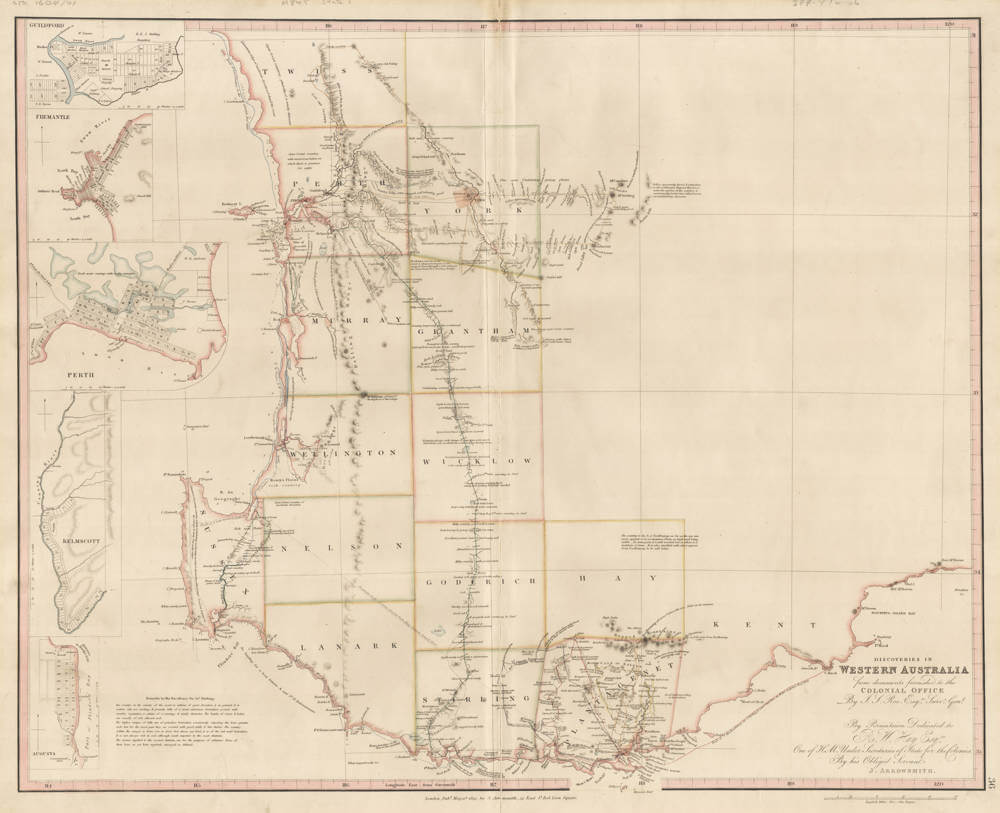
John ARROWSMITH: DISCOVERIES IN WESTERN AUSTRALIA, London, 1833.
First published in the 1835 second edition of 'The London Atlas of Universal Geography'. The map was not included in the 1834 first edition of the atlas. This first atlas state was only preceded by a proof state that was separately issued and not bound in the atlas.
Arrowsmith's important map of the new settlements in Western Australia is one of the earliest maps of the region. It was published just four years after the state became a separate colony in 1829. This was a time of rapid change for Western Australia. John Septimus Roe had been appointed as first Surveyor-General in 1829 (a post he held until 1871) and had commenced his survey work of the Swan River settlement. Fremantle Harbour had been selected as the settlement's port and by 1832 there had been some twenty or so exploratory inland expeditions, especially in the southwestern corner. This map shows the track of Stirling and Roe in the Sulphur in November, 1831.
Condition
Extremely rare first atlas edition. Excellent collector's condition. This first atlas state not in any Australian institution. Lacking in nearly all collections.
Discoveries in Western Australia
Herbert (1989, p.102) points out that of the fifty plates in Arrowsmith's London Atlas at its first issue this is a late addition, the only one with the date 'May 31st 1833', although there were later inclusions than this carrying the date 1834. Herbert tells us that when Arrowsmith realised he was not going to be able to release his atlas in 1832 as he had planned he decided to insert more plates. The Discoveries in Western Australia plate of 1833 (plate 36) was one of these. It was inserted before the plate on Van Diemens Land of 1832, which was the original plate '36'. The Van Diemens Land plate thus became plate '37'. The map in most of its issues bears a dedication to 'R.W. Hay One of the Under Secretaries of State for the Colonies' to whom one must surmise that John Arrowsmith had an obligation for making him privy to information held in the Colonial Office files.
The plate appears to have been produced expressly for the Atlas but it is later used in a Parliamentary Report for the year 1838 with the changes noted in state 1838/1. This map is also found issued together with another two maps on one sheet. The two plates have been placed side by side and printed on to one sheet. In this format the map measures 50.0 x 61.5 cm and 28.5 x 31.0 cm. and 22.5 x 31.0 cm. on a sheet 54.0 x 94.0 cm. Two plates appear to have been used and the left neat line of the Discoveries map cut off where the maps abut. Without the addition of the second map this exemplar is the same as the second state described. Only these issues shown below have been found.
Seven states have been distinguished. This map shows the area in the extreme south-west of the continent south of Perth, at a scale of almost 1:1 000 000. It had five inset maps on the left hand side of the main map. These were for the towns of Guildford, Augusta, Kelmscott, Perth and Fremantle. Then in a later state a sixth inset of the Perth region was added centre right.
The Discoveries plate had a life of six years during which time no change was made to the internal information on the map. Only the imprint was updated as time passed and finally in 1838 the map was used in a Parliamentary Report. The original dedication to R.W. Hay was erased as was the plate number (although the latter not very effectively as on some copies this can still be discerned). A second imprint statement appears beneath the bottom neat line showing it was printed for parliamentary use. An additional marginal title appears top right outside the neat-line which reads Statistical Report on Western Australia 1837.
The Discoveries title also appears combined with two charts of Cockburn Sound and King Georges Sound on one sheet previously referred to above.
This is one of those plates that illustrates the confusion which characterises early printings of Arrowsmith's plates. He moved premises from 33 East Street to 35 Essex Street some time in 1834 one would surmise, but yet issues have been found with the address of 35 Essex Street issued in May 1833. It is suggested that he omitted to alter the date of these particular exemplars. Is any case, it didn't really matter as there was no change to the internal content.
So why did Arrowsmith lose interest in his original map of Western Australia? One possibility is that he realized early on that he had not allowed sufficient space on the plate to permit a northward as well as an eastward extension of the map.
Seven states are known:
Discoveries in Western Australia, 1833/1 (a proof state without the plate number '36', separately issued)
Discoveries in Western Australia, 1833/2 (the first atlas edition of the map, published in 1835)
Discoveries in Western Australia, 1833/3
Discoveries in Western Australia, 1833/4
Discoveries in Western Australia, 1833/5 (1834)
Discoveries in Western Australia, 1833/6 (1838/1)
Discoveries in Western Australia, 1833/7 (1838/2)
Literature:
Herbert, Francis, 'The 'London Atlas of Universal Geography' from John Arrowsmith to Edward Stanford: Origin, Development and Dissolution of a British World Atlas from the 1830s to the 1930s', Imago Mundi, vol. 41, 1989, pp. 98-123.
(Dorothy Prescott)
John Arrowsmith (1790-1873)
John Arrowsmith (1790-1873) was one of the most influential British cartographers of the nineteenth century. Hailing from a family of cartographers and geographers, he inherited his family’s mapmaking business and created one of the most popular and accurate atlases in the mid-nineteenth century. He produced the largest scale maps, constructed mostly from official government sources, of the British colonies during the early to mid nineteenth century period.
John Arrowsmith was born at Winston, County Durham, England. He was the nephew of Aaron Arrowsmith, another English cartographer.
In 1810 he joined his uncle in the cartography business. They built on Aaron's A map exhibiting all the new discoveries in the interior parts of North America 1811 version which was heavily based on information provided by the Hudson's Bay Company, Indian maps, and British Navy sea charts to produce and publish an updated map: North America in 1821. Their contributions to Canadian cartography led to Mount Arrowsmith, situated east of Port Alberni on Vancouver Island, British Columbia, being named for them.
Aaron's sons Aaron Jr. and Samuel were substantially younger than John but inherited their father's business when they were young men (21 and 18 respectively) when Aaron Sr. died in 1823. John took the £200 left to him by his uncle and began working on his own. Aaron Jr and Samuel did not have the skills of their father and cousin and their contributions to cartography were minimal. Regardless, the three Arrowsmiths were founding members of the Geographical Society of London in 1830. Aaron Jr. left the family firm in 1832, and upon the death of Samuel in 1839, John purchased the assets and merged them into his own business.
The Arrowsmith River in Western Australia was named by Sir George Grey after Arrowsmith, who later produced the maps for the published journals of Grey's two Western Australian expeditions. In 1863 he received the gold medal of the Royal Geographical Society, which was what the Geographical Society of London was known as after gaining the patronage of King William IV.
He died at home in Hereford Square, South Kensington, London on 1 May 1873.
(Wikipedia)
Related Categories
Related Items


