Leen Helmink Antique Maps
Antique map of the World in Oval Projection by Jodocus Hondius I
The item below has been sold, but if you enter your email address we will notify you in case we have another example that is not yet listed or as soon as we receive another example.

Stock number: 18878
Zoom ImageCartographer(s)
Jodocus Hondius (biography)
Title
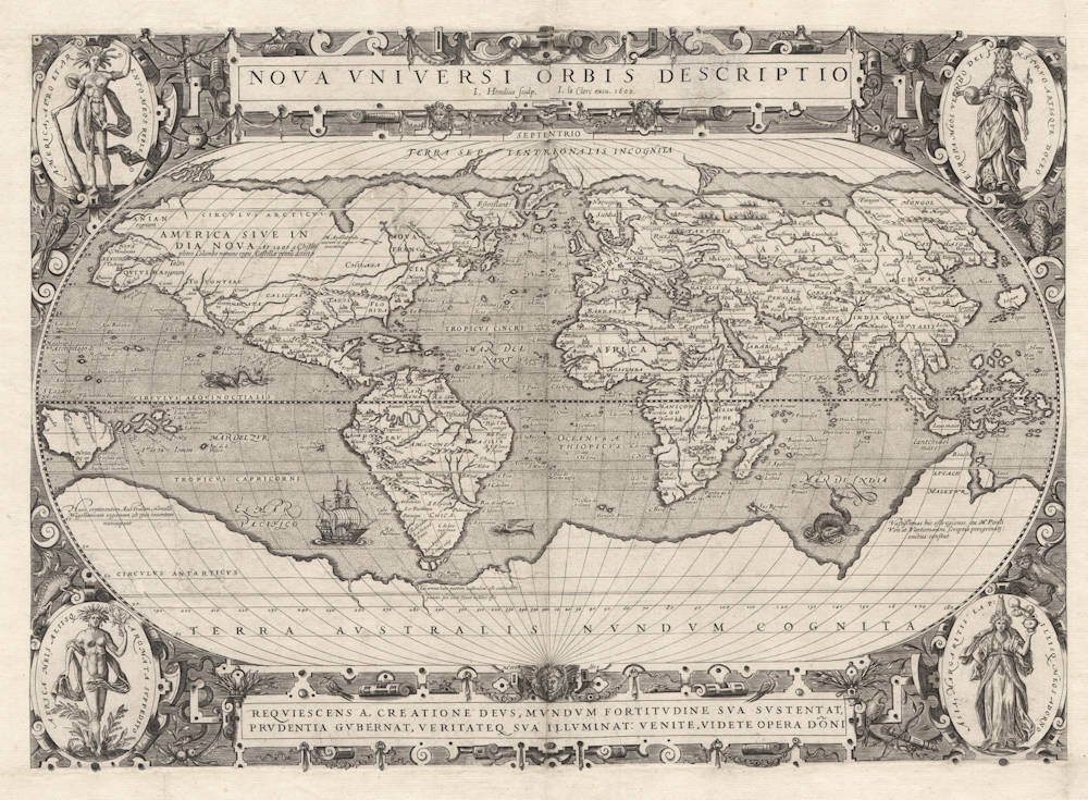
Nova Universi Orbis Descriptio
First Published
London, 1590
This Edition
Paris, 1602
Size
33.5 x 51.5 cms
Technique
Condition
pasted on larger sheet
Price
This Item is Sold
Description
Exceptionally rare and important map of the world by Jodocus Hondius. The map was published as a separate sheet and is of exceptional rarity. One of seven copies known, and the only copy in private hands. No copy in America.
The map was engraved by Jodocus Hondius during his time in London and is of highest significance to Sir Francis Drake's circumnavigation of the world, of which Hondius had first hand information.
Reference: Gunter Schilder, Monumenta Cartographica Neerlandica Volume VIII, chapter VII and map 7.2, as follows:
A Set of Seven Folio-sized Maps (before 1590),
Published by Jean le Clerc in 1602
That this set of seven maps - two world maps, maps of the four continents, and Spain, all with the address of Paris publisher Jean le Clerc and the date 1602 - should be discussed here in the context of Hondius's London activities rests on a number of factors which cannot really be proven beyond doubt. Hondius engraved copper plates in London either on commission (as in the case of the Mariners Mirrour, the Molyneux globes and the illustrations for Broughton's works) or on his own initiative (as in the case of the Drake Map and the map of England, Wales and Ireland in two sheets). When he left London for Amsterdam, he took the copper plates in the second category with him; the copper plates in the first category remained behind in possession of the patrons who commissioned them.
It is my opinion that Hondius was commissioned to engrave the present set of copper plates while still in London at the end of the 1580s (in addition to Le Clerc's publication date of 1602, the map of America also displays the year in which the map was originally made, 1589). The map itself is based on the most recent source material available at the time. Among other things, Hondius made use of the world maps of Rumold Mercator and Abraham Ortelius, both dated 1587, and the most recent maps of America (1587) and the Pacific Ocean (1589). The new discoveries are chiefly based on the results of Drake's voyage around the world, which were only published by Hakluyt in 1589. The maps still show a group of islands at the southern tip of South-America, a drawing that Hondius omitted for the engraving of the Molyneux globe (1592) in accordance with the later observations of Cavendish (1586-88) and the Spanish. There is still no trace of John Davis's voyages to the northwest (1585-87). For the decorations, Hondius also made use of the most current examples available at the time: the personifications of the four continents on the oval world map are simplified illustrations from a print series engraved by Philip Galle around 1590 after designs by Marcus Gheeraerts.
The copper plates of the maps remained in the possession of an unknown patron who for some reason was unable to use them, perhaps due to an early death (thousands died of the plague in 1592-93). The Paris publisher Jean le Clerc was apparently able to acquire the plates in England and publish them in 1602. How Le Clerc managed to get hold of the plates is unknown. Given Hondius's reputation, however, it is highly unlikely that he would have engraved these plates in Amsterdam using cartographic information that was already obsolete. After all, he had already produced maps and globes in Amsterdam before 1602 that took into account the latest Portuguese maps by Luis Teixeira and the most recent discoveries of the English (Frobisher, Davis, Harriot, Raleigh) and the Dutch (Barentsz., De Houtman, Warwijck, Outgersz.), Hence, the available facts suggest that Hondius had already engraved this set by 1590, before his departure from London.
Map of the World in 'Oval' Projection, [1590], 1602
During the same period in which Jodocus Hondius engraved a world map in two hemispheres, he also made a world map drawn in 'oval' projection. This map, engraved sometime around 1590, is only known via the edition published by Jean le Clerc in 1602. The null-meridian, which runs west of the island of Fero in the Canary Islands, intersects the equator vertically. Both are divided into intervals of 10°. While the lines of latitude are parallel, the curved meridians meet at both poles. In this method of projection, the central areas are less distorted than those in the higher latitudes and the eastern and western peripheries of Asia and America.
The central part of the upper border of the sheet is taken up by an elongated scroll-work cartouche. In it we find the title of the map in capital letters, followed below by the name of the engraver, publisher, and year of publication. A similar cartouche along the lower border serves as a pendant, and contains the following text (in translation): 'Behold, God rests from His creation, He keeps the world in existence through His strength, governs it through His foresight, and illuminates it through His truth. Come, behold the works of the Lord'.
Hondius copied Ortelius's world map of 1587 – with the exception the decorative borders and drawings at the tip of South America – in all its particulars. Strangely enough, in spite of being dated 1587, only a few exemplars of the latter were available in the German edition of Ortelius's 'Theatrum' (1589); it was finally included in all exemplars of the Latin edition (1592). One may safely assume that a loose-leaf exemplar of the world map reached Hondius at an earlier date – thanks to his many connections in the Southern Netherlands and London. Ortelius's world map of 1587 has four medallions in the corners of the sheet with citations from Cicero and Seneca. Hondius has replaced them with vertical oval panels containing personifications of the four continents.
The development of allegorical representations of the four continents had its roots in Antwerp, where Ortelius reproduced the earliest known depictions of the four continents on the title page of his 'Theatrum' (1570). In the last decade of the sixteenth century, various print series appeared which depicted the four continents, and because they rely on other sources, they offer an expanded view of such imagery in comparison to those of Ortelius. A few of these prints were imitated on contemporary maps. Hondius was inspired by a series which Filips Galle (1532-1612) engraved after designs by Marcus Gheeraerts (1521-1604). This series, which was made around 1590 and depicts the continents with their attributes in addition to the usual decorative elements, would be imitated repeatedly in subsequent iconography. For lack of space, Hondius had to content himself with a highly simplified version. The four continents are depicted as female figures with a clear hierarchical structure: the 'civilized' continents Europe and Asia in the right corners form a direct contrast to the 'wild' continents in the left. Europe, dressed in splendid clothing, wears a crown and carries a scepter and globe as symbols of her power. Asia, just as richly clothed, holds aloft a dish of incense. Africa, nearly nude, holds a branch of balsam as her attribute; worthy of note is the fact that the artist was still afraid to depict a black woman instead of the usual white female figure. The scantily clad figure of America, adorned with a crown of feathers, is depicted with a club.
In terms of content, Hondius follows Ortelius exactly; Ortelius, in turn, took Mercator's wall map of the world (1569) as his model. Shirley has made an analysis of Ortelius's world maps in folio format, and his study considers the content of the maps in more detail. The only deviation in Hondius's map with respect to that of Ortelius is the inclusion of Drake's discoveries. Like Ortelius, Hondius has drawn in an enormous, unknown Terra Australis ('TERRA AVSTRALIS NONDVM COGNITA') with the notice: 'Some call this southern continent Magellanica, after its discoverer'. New Guinea has also been copied, and displays a similar notice: 'New Guinea was recently discovered but whether it is an island or part of the southern continent is uncertain'.
However, in drawing the southern tip of South America, Hondius differs sharply from Ortelius's model. Where Ortelius represents Tierra del Fuego ('Terra del Fuego') south of the Strait of Magellan ('Estrecho di Magallanes') as part of Terra Australis, in accordance with contemporary habit, Hondius depicts it as a group of islands south of the Strait of Magellan ('Fretum Magellanicum'). The southernmost island, situated in the massage between the southern Atlantic and the Pacific Ocean, bears the name 'Ins. Reginae Elisabetae'. An observation on the mainland of Terra Australis states: ‘Cum omnes hanc partem australem esse contenentem putent, pro certo sciant insulas esse'. This statement expresses Hondius's ideas concerning Drake's discoveries before doubts arose as to their accuracy. It shows that Hondius probably engraved the map before 1590, at which point he noted on his 'Drake Broadside Map' that Cavendish and the Spanish asserted that there was a strait, but no archipelago. An additional if brief reference to Drake's voyage (in which his name is not mentioned) appears in the far northwestern part of North America, where the name 'NOVA ALBION' has been placed on either side of the 50th latitude. On the east coast of North America, no account has been taken of the voyages of Frobisher and Davis, or Raleigh's colonization attempt.
In 2003, I located an exemplar in St. Petersburg with an interesting contemporary annotation in Dutch along the lower margin (in translation): ‘Note. This map was engraved and published by Jodocus Hondius around ao. 1590 | the plate was afterward brought to Paris & printed ao. 1602. ....'.
There is also a later state of the Le Clerc edition of 1602. Shirley mentions an exemplar from which the date has been erased, but it has not been possible to retrace it.
(Schilder)
Jodocus Hondius (1563-1612)
Jodocus Hondius the Younger (son) (1594-1629)
Henricus Hondius (son) (1597-1651)
Jodocus Hondius the Elder, one of the most notable engravers of his time, is known for his work in association with many of the cartographers and publishers prominent at the end of the sixteenth and the beginning of the seventeenth century.
A native of Flanders, he grew up in Ghent, apprenticed as an instrument and globe maker and map engraver. In 1584, to escape the religious troubles sweeping the Low Countries at that time, he fled to London where he spent some years before finally settling in Amsterdam about 1593. In the London period he came into contact with the leading scientists and geographers of the day and engraved maps in The Mariner's Mirrour, the English edition of Waghenaer's Sea Atlas, as well as others with Pieter van den Keere, his brother-in-law. No doubt his temporary exile in London stood him in good stead, earning him an international reputation, for it could have been no accident that Speed chose Hondius to engrave the plates for the maps in The Theatre of the Empire of Great Britaine in the years between 1605 and 1610.
In 1604 Hondius bought the plates of Mercator's Atlas which, in spite of its excellence, had not competed successfully with the continuing demand for the Ortelius Theatrum Orbis Terrarum. To meet this competition Hondius added about 40 maps to Mercator's original number and from 1606 published enlarged editions in many languages, still under Mercator's name but with his own name as publisher. These atlases have become known as the Mercator/ Hondius series. The following year the maps were re-engraved in miniature form and issued as a pocket Atlas Minor.
After the death of Jodocus Hondius the Elder in 1612, work on the two atlases, folio and miniature, was carried on by his widow and sons, Jodocus II and Henricus, and eventually in conjunction with Jan Jansson in Amsterdam. In all, from 1606 onwards, nearly 50 editions with increasing numbers of maps with texts in the main European languages were printed.
(Moreland and Bannister)
Related Categories
Related Items


