Leen Helmink Antique Maps
Antique map of the World by van der Aa

Stock number: 19809
Zoom ImageCartographer(s)
Pieter van der Aa (biography)
Title
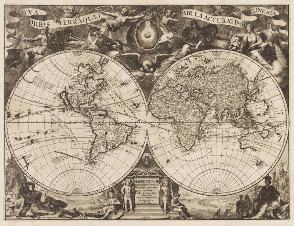
Nova Orbis Terraquei Tabula Accuratissima Delineata
First Published
Leiden, 1713
This Edition
First edition
Size
49.5 x 65.0 cms
Technique
Condition
mint
Price
$ 3,750.00
(Convert price to other currencies)
Description
Very handsome copy of Pieter van der Aa's impressive oversized map of the world, in excellent collector's condition.
Sumptuous world-map, richly decorated with allegories and scenes. The cartography according to the late 17th century with typical features of California as an island and Australia with the Tasman discoveries. A second issue was published in 1729.
The Nova Orbis Terraquei Tabula Accuratissime Delineata stands as a quintessential example of early 18th-century Dutch cartography, emblematic of the golden age of mapmaking in Leiden under the stewardship of Pieter van der Aa, one of the most prolific publishers of his era.
Produced circa 1713, this double-hemisphere world map shows the synthesis of scientific advancement and artistic characteristic of the period. Measuring approximately 50 by 65 centimeters at plate mark, it is a very large copperplate engraving, allowing for detailed rendering of the continents, oceans, and decorative elements. Van der Aa, active from 1690 to 1733, drew upon the latest geographical compilations, incorporating data from Guillaume Delisle and other French cartographers, while adhering to the prevailing Dutch style influenced by masters like Frederik de Wit and Johannes Blaeu.
The map's title, rendered in Latin as 'New Map of the Earth and World, Accurately Depicted,' is prominently displayed atop the engraving. The Great Lakes are fragmented, and the Mississippi River's course is conjectural, reflecting the exploratory zeal of La Salle and others. The depiction of Australia (Nova Hollandia) is rudimentary, confined to partial coastlines known from Tasman’s voyages. South America shows the Strait of Magellan and Tierra del Fuego distinctly. Surrounding the hemispheres are intricate decorations. The upper spandrels are filled with cherubs and the Greek Deities of the Olympus. The bottom has terrestrial scenes with allegories of the continents in exotic attire, maritime battles, and animals, following the Baroque style of the age.
Rarity
The map is scarce, even more so in excellent condition, because of its large size.
Significance
From one of the key publishers at the time, the map bridges 17th-century decorative opulence with 18th-century precision, it captures the zeitgeist of expanding European horizons amid the Age of Enlightenment.
Condition description
Excellent copy, thich and clean paper, wide margins, a crisp and even impression off the copper plate. No restorations or imperfections. Very desirable collector's example of this spectacular map of the world.
Pieter van der Aa (1659-1733)
Records show that van der Aa, born in Leiden in 1659, made an early start in life by being apprenticed to a bookseller at the age of nine and starting his own in business as a book publisher by the time he was twenty-three.
During the following fifty years he published an enormous amount of material including atlases and illustrated works in every shape and size, two of them consisting of no less than 27 and 28 volumes containing over 3,000 maps and plates.
(Moreland & Bannister).
Related Categories
Related Items


