Leen Helmink Antique Maps
Antique map of Texas, southwest and Mexico by Gastaldi
The item below has been sold, but if you enter your email address we will notify you in case we have another example that is not yet listed or as soon as we receive another example.

Stock number: 18660
Zoom ImageCartographer(s)
Giacomo Gastaldi (biography)
Title
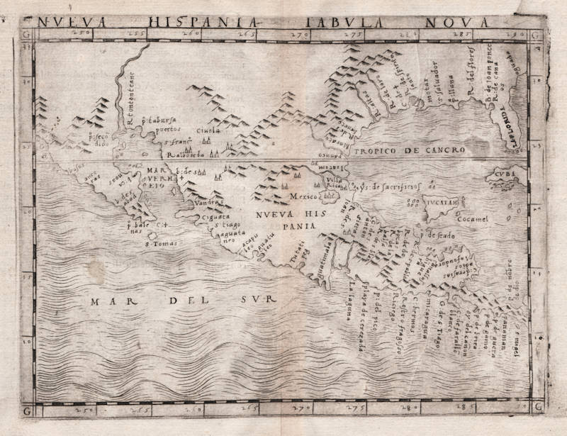
Nueva Hispania Tabula Nova
First Published
Venice, 1548
This Edition
1548 first and only edition
Size
13.0 x 17.0 cms
Technique
Condition
excellent
Price
This Item is Sold
Description
Giacomo Gastaldi's map of the North American southwest coast and Mexico, and the first map dedicated to the region. A cornerstone piece. See also www.mapforum.com/07/7issue.htm
"Gastaldi's original 1548 issue of this map is particularly scarce. [...]
This is an important map showing a more correct west coast cartography than was to be seen a hundred years later when California was shown on most maps to ne an island."
(Potter p140)
"The first map to concentrate on the south-west area was the 1548 Gastaldi map, reissued in 1561 by Ruscelli."
(Potter p159)
"The miniature atlas by Giacomo Gastaldi, of 1548, is of particular interest since it includes the first separate map representations of the US north-east coast; the US south and west and Gulf area; South America; and the islands of Cuba and
Santo Domingo."
(Potter p136)
"This is the first separate printed map of the southern part of North America; the work's delineation of the region is vastly superior to other printed maps of the period, delineating the American Southwest, California, and the Gulf Coast in fine detail. California is a peninsula, and the Seven Cities of Cibola are recorded."
(Suárez)
"This map is the second relating to North America in the Italian edition of Ptolemy's 'Geography' published by Giacomo Gastaldi. Not until Cornelis Wytfliet's 'Hispania Nova', 1597, was this area covered in as much detail. With the accompanying 'TIERRA NVEVA' they are the first copperplate maps devoted to North America. The 'R:de Spirito Santo' appears again as does an insular Yucatan. Topographical details appear inland in the form of mountain ranges, and a peninsular California is depicted, its first appearance in print being on the world map by Sebastian Cabot, 1544. The Spanish had been exploring this region for some time, 'R:tontonteanc' here represents either the Colorado River or the Gila. There were no further issues of it but in 1561 Girolamo Ruscelli enlarged it for his edition of Ptolemy's work."
(Burden 17)
Giacomo (Jacopo) Gastaldi (c.1500-1566)
"In Venice in 1548, Giacomo Gastaldi engraved a fine series of maps for what is seen as the first 'pocket' or miniature atlas."
(Potter p38)
"Praised as 'that most excellent of cartographers', Gastaldi was a native of Piedmont and worked in early life as an engineer in the service of the Venetian Republic before turning in the early 1540s to cartography as a profession. Eventually he was appointed Cosmographer to the Republic.
From 1544 onwards he produced a large number of maps beautifully engraved on copper, using a style which was widely copied by his contemporaries, indeed, his technique marked the final transition away from woodblock printing which had been predominant for so long.
Apart from compiling maps of the world and the continents he was responsible for the maps in an edition of Ptolemy issued in 1548 and in a noted collection of voyages and travels called 'Delle Navigazioni e Viaggi' by Giovanni Battista Ramusio (1485-1557). Many of his maps were included in the Lafreri collections of maps in the 1560–80 period.
Gastaldi is credited with popularizing the idea that a route round the north of the American continent led to a passage which he called the Strait of Anian, named after Marco Polo's Kingdom of Anian. The name appeared on many maps well into the seventeenth century."
(Moreland & Bannister p66)
"Jacopo Gastaldi, 'most excellent' of cosmographers, produced a pocket version of Ptolemy in 1548. 'La Geografia di Claudio Ptolemeo' (with 'criticisms and additions' by Sebastian Münster) contained 26 maps from Ptolemy [..], and 34 new maps (some of the New World)."
(Tooley & Bricker)
"Jacopo Gastaldi, born in Piedmont in about 1500, and by the 1540s cosmographer to the Venetian Republic. At least a hundred maps are attributable to Gastaldi, including his 1548 'Geographia' (published by Nicolo Bascarini). It was a popular edition in Italian prose, and expressly designed in quarto, with maps only 5 by 6.75 inches, so that it could be carried 'nella manica' - in the sleeve. (Quarto is the page size that results when a full-sized printed sheet is folded twice instead of a single time that gives a 'folio' page.).
Gastaldi's contemporaries usually described him as the 'most excellent Piedmontese cosmographer'. As a dedicated professional he worked for a number of publishers, accepting occasional private commissions, as when Venice's all-powerful Council of Ten commissioned him to make fresco maps of Asia and Africa for the walls of a room in the Doge's Palace"
(Tooley & Bricker)
"A small but very elegant Italian [Ptolemy] edition with plates, handsomely engraved in copper by the famous cosmographer Gastaldi. [...]. A whole series of plates of the New World is here met with, for the first time, and some of them are of no slight interest to the history of cartography."
(Nordenskjöld 28)
"Sixty maps are engraved in copper in Mattiolo-Gastaldi's Ptolemy of 1548. [...]. On the title-page is written: 'Con alcuni comenti et aggiunti fattevi da Sebastiano Munstero Alamanno, but this evidently refers to the text, not to the maps, which, from a geographical point of view as well as in their technical execution, are immensely superior to those of the learned geographer and Hebrew professor at Basel.
The work is dedicated by Iacobo Gastaldi to Leone Strozzi, 'dignissimo Signore di Capua', whereupon follows an 'A li lettori', where the publisher, Giovanbattista Pedrezano, is highly complimented, for not having spared any expense in getting the maps as finely and well executed as possible, and for having reduced their size as to allow of anybody, without difficulty, carrying the work 'nella manica'. We thus have here the first atlas expressly said to be published in a pocket form."
(Nordenskjöld 40)
"This edition of Ptolemy's 'Geography' was the most comprehensive atlas produced between Martin Waldseemüller's 'Geographia' of 1513, and the Abraham Ortelius 'Theatrum' of 1570. It was the first to contain regional maps of the American continent.
Giacomo Gastaldi had the maps beautifully engraved on copper. This marks a turning point, from now on the majority of cartographic works used this medium. As it was a harder material than wood it gave the engraver the ability to render more detail. Born in Villafranca, Piedmont, Gastaldi became Cosmographer to the Venetian Republic, then a powerhouse of commerce and trade. He sought the most up to date geographical information available, and became one of the greatest cartographers of the sixteenth century."
(Burden 16)


