Leen Helmink Antique Maps
Antique map of California to Alaska by Acosta/Metellus
The item below has been sold, but if you enter your email address we will notify you in case we have another example that is not yet listed or as soon as we receive another example.

Stock number: 18383
Zoom ImageCartographer(s)
Johannes Metellus (biography)
Title
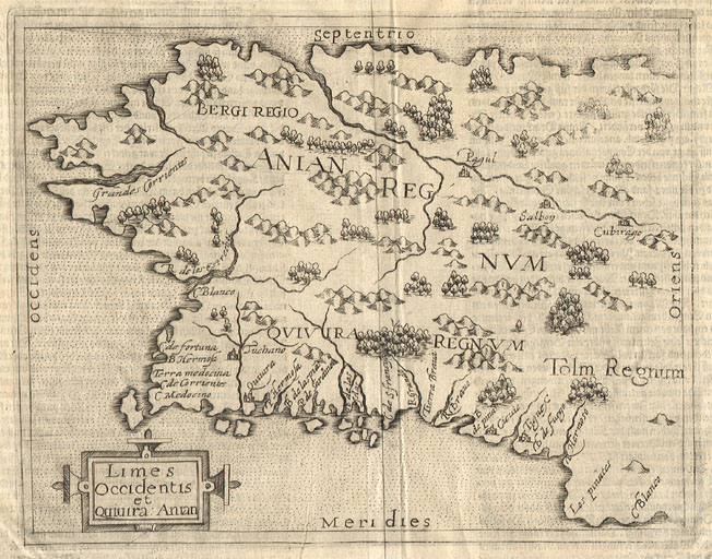
Limes Occidentis et Quivira Anian
First Published
Cologne, 1598
This Edition
1598 first edition
Size
18.5 x 24.2 cms
Technique
Condition
excellent
Price
This Item is Sold
Description
Extremely rare and early map of the north American west coast. A German derivative of Wytfliet's map, engraved by Johannes Metellus and published by José de Acosta. It covers the cost from Mexico to the Strait of Anian, separating America from Asia. A cornerstone collector's map of the region.
From José de Acosta's Geographische Und Historische Beschreibung Der Uberauss Grosser Landshafft America, Cologne, 1598.
"As with the Cornelis Wytfliet a year earlier this publication contained a set of maps relating to the Americas only. All but one are derived from the Wytfliet. These were used to illustrate this German edition of José de Acosta's De Natura Nova Orbis, first published in Salamanca, 1588 [but without the maps]. Acosta was a Spanish Jesuit missionary, historian and cosmographer. The maps, however, are attributed to Johannes Matalius Metellus (Jean Matal in his native French), a very well respected geographer of his day. In the America sive Novus Orbis of 1600, he is named as the cartographer of the maps but, most probably, did not see their completion as he died in 1597. The work was finished by a friend, Meurer identifies him as Conrad Loew, a pseudonym for Matthias Quad.
Born in Burgundy, 1520, Metellus spent much of his working life in Louvain where, of course, the Wytfliet atlas was published. However, he spent his last years in Cologne, dying in 1597. This leads us to the possibility that the Metellus actually pre-dates the Wytfliet as the first atlas concentrating on America. A number of questions are posed. Is there an earlier edition still unknown, as all issues are extremely rare? Is Metellus the true author of the Wytfliet maps? He did reside in Louvain for some time? Closer comparison of the two series of maps shows that almost certainly the Metellus maps are gleaned from the Wytfliet."
(Burden).
"From José de Acosta's De Natura Nova Orbis, this very rare map by Johannes Metellus, like most of the others in the set, is a reduced version of the Cornelis Wytfliet map of the same name in 1597. Unlike it, however, there are no latitude or longitude markings and no Circulus Arcticus. It covers the entire Pacific coastal portions of the present day United States and Canada. The general shape derives from that of Gerard Mercator's world map of 1569, with a pronounced bulge similar to that of Alaska as we know it today.
It has been proposed that the Metellus maps in fact precede the Wytfliet.
All issues have text on the back."
(Burden).
"The Wytfliet is known to have been produced in 1597, the Metellus, which is much rare and seldom available on the market, is usually dated 1598 but some scholars have argued the possibility that it may precede the Wytfliet. The Metellus is acknowledged as, by far, the finer engraving of the two, which, along with its rarity and importance, makes it a focal point of any collection of early American maps."
(Casten).
References
Richard B. Arkway catalogue 22 item 1 (Acosta, 1598)/ Gole (1988) p. 20 (about Metellus)/ Koeman (1967) vol. 3. p. 2/ Meurer (1988) p. 47 ACO. 1 & 2, p. 162 MET. 9 & 11.
Condition
First and only state. This example from the 1598 first edition (ACO 1). Excellent condition. Wide margins all around. Minimal water stains in upper and lower margin, far from the printed area. Faint shine through of the letterpress text on verso. No paper restorations or imperfections. Strong early and even imprint of the copperplate. Excellent collector's example.
Johannes Metellus (1520-1597)
"Metellus is an obscure figure about whom little is known except that he was born in Louvain, later being heard of in Cologne where he was probably a publisher as well as a cartographer. He compiled a set of maps of America (with a World Map) very similar to those of Cornelis van Wytfliet with which they are often confused. The maps by Metellus are much rarer than those of Wytfliet."
(Moreland & Bannister).
Johannes Metellus [Jean Matal; Germanus; Matalius; Natal; Sequanus] (1520-1597) was born in Burgundy and died in Augsburg. He was a geographer and antiquary in Louvain/Leuven and later in Cologne. He contributed to geographical texts including Braun & Hogenberg's Civitates Orbis Terrarum.
(Hubbard).
Only a handful examples of the Metellus books are known, see Burden 115 for a list of locations.
Related Categories
Related Items


