Leen Helmink Antique Maps
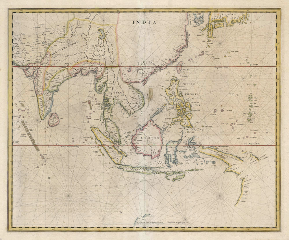
Antique map of South East Asia by Hessel Gerritsz


Stock number: 18918
Zoom ImageCartographer(s)
Hessel Gerritsz (biography)
Title
India
First Published
Amsterdam, 1632
This Edition
Amsterdam, 1634
Size
41 x 50 cms
Technique
Condition
excellent
Price
This Item is Sold
Description
Exceptionally rare sea chart by Hessel Gerritsz, master map maker of the VOC, the Dutch East India Company. This chart is the first accurate map of the Far East. Of highest significance.
Hessel Gerritsz, the official cartographer of the VOC, had produced this copperplate shortly before his unexpected death in 1632. After the passing away of Gerritsz, Blaeu took over the position as VOC mapmaker, helped with the appointment by his friend Laurens Reael, former VOC governor of the East Indies, who was back in the Netherlands and who was by now one of the VOC directors in Amsterdam.
In his new position Blaeu had access to the latest navigational information available from the East Indies, including all ship's logs and charts. Blaeu also got Gerritz copperplate for this map, that had actually been designed as a maritime chart for use at sea by the East India Company. Blaeu changed it from a navigational chart into an atlas map to include in his Atlas Novus of 1634.
Condition
Several tiny worm holes professionally restored, notably in the Philippines, Siam and Borneo. An early strong and even imprint of the copperplate. Paper tint slightly mellow. Attractive original colour. Wide margins all around. Overall a very desirable example of an otherwise unobtainable chart.
First state of Blaeu's map of the East Indies
This very rare, first state of Blaeu's map of the East Indies is of utmost importance as it was the first regional map in an atlas to show the discoveries of Australia. It was also the first to chart those discoveries on both the west coast of Australia and Cape York Peninsula.
(Simon Dewez)
Hessel Gerritsz (1581/82-1632)
Master engraver and Map Maker, who 'ruled' the Seas
Hessel Gerritsz. (1580/81) ranks among the most important and influential cartographers of the early-seventeenth-century Amsterdam. He started his career in Willem Jansz. Blaeu's workshop. About 1608 he established himself as an independent engraver, mapmaker and printer.
In his position as chart-maker of the Dutch East India Company (VOC) and West India Company (WIC) he had access to the latest ship logs, he equipped the ships to the east and the west with the latest charts, and was the best informed cartogrepher of the era.
(Schilder)
"Unquestionably the chief Dutch cartographer of the 17th century."
(Keuning)
His fame as cartographer grew rapidly to the point that on 16 October 1617 he was appointed the first exclusive cartographer of the Dutch East India Company (VOC), probably the most strategic position a cartographer could have in those days. He got the position by recommendation of Petrus Plancius, chief scientist and advisor of the VOC, who did not get along with the more senior Willem Blaeu. Gerritsz kept this post until his death in 1632, after which the position was given to Willem Blaeu after all (Plancius had passed away in 1622).
(Wikipedia)
In 1617, Hessel Gerritsz. published a large wall map of Italy in six sheets. His model for the geographical content was the wall map published by Giovanni Antonio Magini (1555-1617) in 1608, which was a milestone in the seventeenth century Italian cartography.45 He gave his wall map an extra cachet by extending the map image with town views and costumed figures. The design of the costumed figures is attributed to Pieter Lastman (1583-1633), the exquisite execution betraying the hand of the master etcher Gerritsz.
Gerritsz.' wall map of Italy was copied shortly after publication by the publishing house of Willem Jansz. [Blaeu]. To protect himself against such plagiarism in the future, he requested a patent from the States General. On 27 January 1618, they granted him a general patent in which amongst other things it was forbidden in any way to reproduce, copy or distribute his maps, descriptions of lands and prototypes ('models') both written or printed. Such an extensive patent was highly unusual, in the most cases a privilege was granted for precisely defined publications. Hessel Gerritsz. was so highly regarded in 1617, that he received such an important privilege from the States General in January 1618, shown by his appointment as instructor in geography for the Councillors of the Admiralty at Amsterdam on 15 July 1617 and as map maker for the Chamber Amsterdam of the VOC on 16 October 1617. With both appointments his old employer Willem Jansz. [Blaeu] was passed over.
With the appointment of Hessel Gerritsz. as map maker of the Chamber Amsterdam – a function which he held until his death in 1632 – the VOC brought a driven person into the house who undertook the organization of equipping the ships with charts and navigational aids with vigour. The instructions issued to him by the Chamber Amsterdam in 1619, give a good insight into what was expected from a map maker of the VOC. Because all merchants, masters and pilots were obliged to deliver the journals, maps and drawings made during the voyage to him on their arrival in Texel, with the aid of this material he was able to improve and expand the charts for the navigation to and from the Indies. The influential position that Hessel Gerritsz. held in equipping the VOC ships with charts cannot be overrated, for within a very short period he developed certain prototypes of charts, which – with some small adjustments – were part of the standard equipment of a VOC ship, sometimes until the middle of the eighteenth century.
(Schilder)
Related Categories
Related Items


")


