Leen Helmink Antique Maps
Antique maps and prints of Borneo - 4 maps/views by Olivier van Noort
The item below is on hold, but if you enter your email address we will notify you in case it becomes available, or if we have another example that is not yet listed, or as soon as we receive another example.

Stock number: 18901
Zoom ImageCartographer(s)
Olivier van Noort (biography)
Title
Borneo Insula
First Published
Amsterdam, 1602
This Edition
1646
Size
each ca 15 x 23 cms
Technique
Condition
excellent
Price
This Item is On Hold
Description
The set of all three maps/views of the Borneo visit of Olivier van Noort's account of his circumnavigation of 1598-1601. Added is a fourth print of a Portuguese Galleon stuck on a reef off the coast of eastern Java.
The series gives a vivid account of his adventures in Borneo and Brunei.
These prints/maps were first published by Cornelis Claesz in Amsterdam in 1602, to accompany Olivier van Noort's account of his three year circumnavigation of 1598-1601). They were engraved by two of the foremost engravers of the day, namely Baptista van Doetecum and Benjamin Wright. Here the imprints are in final state, with numbers added in the lower corners, from Isaak Commelin's 1646 "Begin ende Voortgangh of the VOC".
The imprints of the copperplates are strong and even. The left and right margins are short, as often. There are no other imperfections or restorations, overall condition is excellent.
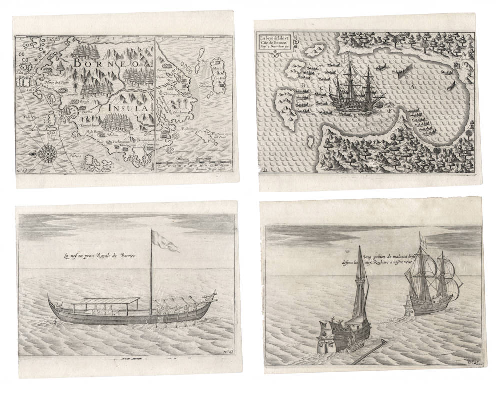
1. Map of Borneo
The first print is the overview map of Borneo. It is the second map dedicated to the island, only preceded by the 1598 miniature map by Langenes. Instead of a title cartouche, "BORNEO INSULA" is engraved in large capitals in the island.
North is at the left, so the map is oriented to the east. A latitude scale is along the top, and the equator runs vertically through the map. The map is signed in the lower right by the engraver, Benjamin Wright. The scalebar is in Dutch nautical miles of 15 in a degree, so each Dutch mile equals 4 modern nautical miles of which there are 60 in a degree. Old Dutch nautical miles were very pragmatic for pilots, because the rough average speed of a large merchant ship was one Dutch mile per hour, so each mile in the scalebar would approximately correspond to one hour of sailing.
The southern part of Borneo exactly follows the Lodewijcksz chart of the first Dutch fleet of 1595-1597, a chart that had also been published by Cornelis Claesz and that Van Noort no doubt used on his voyage. As on that Lodewijcksz chart, Makassar is curiously and incorrectly depicted as an island city south of Borneo, instead of its correct location on nearby Celebes.
For the northern part of Borneo, Benjamin Wright copied Plancius 1592-94 Spice map.
The map shows the track of the 'Mauritius', coming from the Philippines, sailing along Borneo's north coast, anchoring in Brunei Bay, and leaving through the "Gateway of Borneo" aiming for "the mainland of Malacca", meaning present day Malaysia.
"The success of the pioneering Dutch expedition to the Indies under Cornelis de Houtman infused such a fever of confidence in the Netherlands that in 1598, the very year following the fleet's return, five different companies financed the voyages of twenty-two ships to the Far East. One of the fleets, under the command of Olivier van Noort, reached the Philippines, Borneo, and Java by Magellan's route, around South America and across the Pacific, completing the first Dutch circumnavigation. An account of the voyage contained a map of Borneo recording van Noort's tracks into Brunei Bay in December of 1600.
Geographically, however, the map reflects nothing from the voyage. The map was itself derived from Iberian prototypes already popularized on the Linschoten map of 1595. It was reused as a separate map in Langenes' miniature atlas of 1598, with some differences in interior rivers and nomenclature, and the same geography was employed again in 1616 by Bertius.
The most striking aspect of this mapping of Borneo is that the island's east coast (top of map) is merely a hypothetical line. This conspicuous void in European knowledge of Borneo was a result of the route taken by early European mariners making the run between Malacca and the Spiceries. After leaving Malacca and passing eastward through the Singapore Strait, they generally went south by the western coast of Borneo, crossed the Java Sea, and followed the northern coast of Java to Sulawesi. This route missed the eastern coast, and thus, as Linschoten reported, “the breadth (of Borneo) as yet is not known nor discovered.” Not until the end of the sixteenth century did it become common for mariners to sail around Borneo to the Moluccas, leading to the mapping of the island's eastern shores in the seventeenth century.
Few of the places found on these earliest maps of Borneo were mentioned by subsequent visitors. Some of the settlements recorded were cited by the Portuguese historian Fernão Lopes de Castanheda during the 1550s as principal seaports used by his countrymen. One is Marudo, marking the bay at the northern tip of the island (upper left), a name which the bay has retained to this day (Teluk Marudu). Monte di S. Pedro is Mount Kinabalu.
Another place cited in Portuguese records is Taniampuro, or more commonly, Taiao pura. This is probably Tandjong Pura, the old capital of Matan, although Matan lies on the west coast while Taiao pura was normally placed on the south. The Portuguese knew Taiao pura as a source of diamonds; Linschoten, repeating what he had learned in Goa, seems to be describing the fat river system which mapmakers placed by Taiao pura when he refers to it as a strait: “there is a straight called Tania pura ... where many diamonds are found, that are excellent.” Laue, another Portuguese port-of-call, was mentioned by Pigafetta (though he did not reach it), and could conceivably be the enigmatic Lochac of Polo, the Van Noort map follows most of his contemporaries in placing it in the southwest of the island."
(Suarez)
2. Map of Brunei
The second print is the map/view of the Bay and City of Brunei, with the 'Mauritius' at anchor and surrounded by many local praws. It is the first map of Brunei and must be attributed as an original work by van Noort. The map is titled "La baye de Isle et Cite de Borneo" and is signed by engraver Baptista van Doetecum.
Van Noort was only the second European explorer to visit Brunei, after Pigafetta in 1521.
"Van Noort's ship is shown in the large bay of Brunei, marked Borneo. The Dutch captain relied on Chinese pilots in his employ to serve as ambassadors to the sultan, who had to be persuaded that the visitors were not Spanish. The map's depiction of local boats clustered round van Noort's vessel refers to the appearance of almost one hundred proas in the bay on January 1st, 1601. They surrounded the ship and their crews attempted to cut its anchor cable.
The descriptions of the sultanate left by both Pigafetta in 1521 and van Noort eight decades later would both sound familiar to a modern visitor. Pigafetta placed the city a fair distance up the Brunei River, and describes it as built entirely over the water, with wooden houses sitting high on pilings, as much of the city of Brunei remains today. Only the raja and some of his chiefs, Pigafetta observed, live on the land proper. Noort judged the village to lie some three miles upriver, and to comprise about 200 houses, built on a swamp, with its residents traveling from house to house by proa. Noort, like many before him, praised the island's camphor as the finest available.
Although it is generally agreed that the name of the island of Borneo probably derives from Brunei, another theory is suggested by the Ibans of Sarawak, who claim that the name derives from buah nyior, a Malay term for coconut."
(Suarez).
3. Royal barque of Brunei
The third print depicts the royal barque of the Sultan of Brunei, with whom the Dutch negotiated for pepper and fresh supplies.
4. Print of a Portuguese Galleon wrecked in Eastern java
The fourth print is not of Borneo but of East Java. After Borneo, Van Noort had intended to buy Spices in Bantam but was warned that the Portuguese were after him. Going to the spice islands was not possible because of the monsoon season. Because he had no good charts and no good pilot, Van Noort decided to rely on Lodewijcks' journal to buy pepper at Gresik in East Java and get out of the Indies via Bali Strait. On the way, off the coast of Pasuruan, a large Portuguese Gallion was stuck on a reef, with a crew of 700-800. They said that they were on a trip from Malacca to the spice islands and desperately needed to be rescued, but Van Noort was down to 45 man and he knew that the Portuguese had received news over land of his sailing plans and were sent out from Malacca to ambush him in this strait between Java and Madura.
Van Noort's account of Borneo
For context we include below the events of Olivier van Noort's account, after leaving Manila, as transcribed and summarized by Kerr.
"After [the naval battle with the Spaniards in Manila Bay on Dec 14, 1600], Van Noort made sail for the island of Borneo, the chief town of which island is in lat. 5° N. while Manilla, the capital of Luçon, is in lat. 15° N.
On the way to Borneo, they passed the island of Bolutam, [Palawan or Paragua,] which is 180 miles in length from N.E. to S.W. They came to Borneo on the 26th December, putting into a great bay, three miles in compass, where there was good anchorage, and abundance of fish in a neighbouring river, and the fishermen always ready to barter their fish for linen.
Van Noort sent a message to the king, desiring leave to trade; but suspecting them to be Spaniards, he would come to no terms till his officers had examined them with the utmost attention, after which they had trade for pepper with a people called Pattannees, of Chinese origin. Both these and the native Borneans were fond of Chinese cotton cloth, but the linen from Holland was a mere drug, and quite unsaleable.
In the mean time, the Borneans laid a plot to surprise the ship; for which purpose, on the 1st January, 1601, they came with at least an hundred praws full of men, pretending to have brought presents from the king, and would have come on board the ship; but the Dutch, suspecting their treachery, commanded them to keep at a distance from the ship, or they would be obliged to make them do so with their shot, on which the Borneans desisted.
Borneo is the largest of all the islands in the East-Indies; and its capital, of the same name, contains about 300 houses, but is built in a dirty marshy soil, or rather in the water, so that the inhabitants have to go from one house to another in their praws. The inhabitants all go constantly armed, from the noble down to the fisherman; and even the women are of so martial a disposition, that on receiving an affront, they instantly revenge it, either with a dagger or a javelin. This a Dutchman had nearly proved to his cost; for having offended one of these viragoes, she set upon him with a javelin, and had surely dispatched him, if she had not been prevented by main force. They are Mahometans, and so very superstitious, that they would rather die than eat of swine's flesh, nor will they keep any of these animals about them. The better sort have a cotton garment from the waist down, with a turban on their heads; but the common people go entirely naked. They continually chew betel and areka, which is also a common practice in many other parts of the Indies.
On the 4th January, four Borneans came to the ship, intending to have cut the cables, that she might drive on shore and become their prey; but the Dutch fortunately discovered them, and drove them away with shot, when they left their praw behind, which the Dutch took, to serve instead of their own boat, which they had lost at the Philippines. Seeing no hope of any profitable trade at this place, they now left it, intending for Bantam, not much pleased either with the country or the people. The day after leaving Borneo, they met a junk from Japan bound for Manilla, which informed them of a great Dutch ship being forced by tempests into Japan, all her company having died by sickness and famine except fourteen. They came first to Bongo, in lat. 34° 40' N. [Bungo in about lat. 33° N.] whence the emperor of Japan ordered them to remove to Atonza, in lat. 36° 30' N. [Osaka in lat. 34' 55' N.] They alleged that they were allowed to trade, and to build a new ship, with liberty to dispose of themselves afterwards as they pleased. From this account, it was not doubted that this was the admiral of Verhagen's fleet [This was the ship in which William Adams sailed as pilot, as related on a former occasion, being the Hope, commanded by James Mahu, one of five ships from Rotterdam. Van Noort already had occasion to meet with two of these in the Straits of Magellan]; and dismissing the Japanese vessel, they passed the [equator] line a third time, and proceeded for Bantam, in no little fear and danger, for want of an experienced pilot and good charts.
The 16th they took a junk belonging to Jor or Johor, in which they procured an experienced and skilful pilot, who came in good time to save them from shipwreck, which they had otherwise most probably suffered in these dangerous seas, so thick set with shoals and islands on every side, with which they were entirely unacquainted; and besides, they were now reduced to one anchor, and one solitary cable almost worn out. The 28th they came to Jortan in the island of Java, where they had news of several Dutch ships being at Bantam. The city of Jortan consists of about 1000 houses built of timber, and its king commands over a considerable portion of that end of the island, and had lately conquered Balambuan, a small island S.E. from Jortan. The people in these parts are said to be Mahometans; yet, as pagods are still in use, they seem to retain some mixture of the old Indian superstitions, or at least some remnant of paganism is tolerated among the common people. Their chief priest at this time was an old man, said to be an hundred and twenty years of age, who had a large household of wives, who fed the old man with their milk.
Sailing past Jortan [the trading port city of Gresik in East Java, in the strait between Surabaya and the island of Madura], they saw a large Portuguese ship of 600 tons, sticking fast among the shoals [off the coast of Pasuruan]. She was bound for Amboina, on purpose to have engrossed all the trade of that place; at least such was the report of the Portuguese; but Van Noort strongly suspected she had been sent out to cruize for the purpose of intercepting him. He was, therefore, the less concerned for her misfortune, and the less careful in assisting her crew, originally of between six and seven hundred men, many of whom were still on board, and in great danger of perishing.
The 5th of February, they passed the straits between Balambuan [port of Banyuwangi] and Bally 9the Island of Bali], leaving Java on the N.E. [so sailing south of Java]. On the 11th, finding themselves in lat 13° S. they directed their course for the Cape of Good Hope. On the 18th, having the sun vertical at noon, their latitude was 11°20' S. and here a calm began which lasted eleven days. The 11th March they were in lat. 24°45' S. and in 28°10' S. on the 24th."
(Kerr after van Noort)
Olivier van Noort (1558-1627)
The voyage of Olivier van Noort (1598-1601)
The financing of Van Noort's fleet was a Northern Netherlands venture. Merchants from Amsterdam and Rotterdam worked together in the Magellan Company. The fleet consisted of two ships and two yachts. The innkeeper Olivier van Noort (1558/59-1627), who hailed from Utrecht and lived in Rotterdam, was appointed admiral of the 'Mauritius'. The 'Hendrick Frederick' was put under the command of Vice-Admiral Jacob Claesz van Ilpendam; the yacht de Hoop sailed under Jacob Jansz Huydecooper; and the yacht de Eendracht was under Pieter Esaiasz de Lint. The chief merchant was Lambert Biesman. Further, the role of the English pilot Melis should not go unmentioned. Having been along on Cavendish's voyage around the world, he was able to provide Van Noort with much practical information. In total, the fleet sailed with 240 men on board.
In light of Prince Maurits' letter of commission to Van Noort, there is no doubt about the purpose of the expedition. With his four ships, Van Noort was supposed to sail through the Strait of Magellan and then capture a Spanish silver ship on the west coast of South America. He would then use the booty to buy spices and trade goods in the East Indies. Ultimately, the ships would return the Netherlands by the Cape route, thereby completing the voyag around the world. In this way, the investments to be made by the company were minimal, whereas the expected profits were enormous. This plan clearly demonstrates that the company took the voyage of Thomas Cavendish as its model and deviated from the plans that the other Dutch companies had in mind when fitting out fleets for the East Indies at that time. In practice, however, things turned out differently than the Magellan Company had expected.
A delay of the Amsterdam contingent meant that Van Noort could not set sail with his fleet until 13 September 1598. The voyage headed south along the northwest coast of Africa and the Canary Islands in the direction of the Gulf of Guinea, by then a route that was not unknown to the Dutch. They stopped at Ilha do Principe to take on fresh supplies. There, the Portuguese gave Van Noort a hostile reception. One of the fatalities was the experienced pilot Melis; his loss was a severe blow to the expedition. At the end of December, the ships set course for Brazil, reaching it in just over a month at 22° S. There, the Portuguese had built strong fortifications, particularly around Rio de Janeiro. Thus, the Dutch, who were suffering from scurvy and a shortage of water, had no chance to land and take on fresh supplies. Coasting slowly southward, Van Noort realized that it would be hard to get through Magellan Strait before winter set in. Therefore, in March he decided not to sail any farther south. Instead, he would sail to the east and spend the winter on St. Helena. This attempt failed, however; he could not find the island and had to return to the coast of Brazil. For the time being, they were able to revictualize on the uninhabited island of S. Clara. There, since 'de Eendracht' was already leaking, they distributed its cargo over the other three ships and put the torch to the yacht.
They resumed the journey south on 21 June, setting course for 'Porto Desire' (named after Cavendish's flagship) at the mouth of the Deseado River, which they reached on 20 September 1599. Van Noort stayed in this sheltered harbor (47°40'S) for six weeks. There, the ships were repaired and the supplies were replenished with large amounts of salted seal and penguin meat. The skipper of de Hoop died in October. His post was taken by Pieter de Lint, and the ship was renamed 'de Eendracht'.
The crew raised anchor on 29 October and set course for the Strait of Magellan. The three ships arrived there on 4 November, but Van Noort was unable to enter the strait till four weeks later. Confronted with very changeable winds and strong currents, it took 116 days to reach the exit to the Pacific Ocean. In fact, it took Van Noort longer than any of his predecessors to pass through the strait. The passage took Magellan 38 days, only 16 for Drake to pass, and 49 for Cavendish to reach the Pacific. Halfway through, the ships encountered - entirely to their surprise – 'het Geloof', commanded by Sebald de Weert, one of the members of Mahu's squadron who had stayed on there. Because of the shortage of men and provisions, De Weert had decided not to continue the voyage but to head home instead. Another incident occurred during the passage through the Strait of Magellan. On the inhospitable coast, Van Noort put Vice-Admiral Jacob Claesz off the ship for disobedience.
Shortly after reaching the Pacific Ocean on 29 February 1600, the ships were separated in a heavy storm. Van Noort never set eyes on the 'Hendrick Frederick' again (The ship reached the Moluccas in a desolate condition and was bought by the king of Ternate, This did not become known in Holland until two years after Van Noort's return). Thus, the plan set forth by the Magellan Company had to be carried out by the two remaining ships, the Mauritius and de Eendracht, and only 90 men. This was an impossible mission. By then, the Spaniards were already well aware that the Dutch had arrived, so there was no chance of launching a surprise attack. The Dutch were only able to capture a single ship, the 'Bon Jesus', and it did not even have a valuable cargo on board. In May 1600, Van Noort was forced to start the crossing to the Philippines. At Guam, one of the Ladrone Islands, he made a brief provisioning stop. Then, he resumed the voyage to the Philippines.
On 14 December, outside Manila Bay, he was engaged in heavy battle with two heavily armed ships of the Spanish governor Antonio de Morga. Van Noort had one ship, the 'Mauritius', and just 53 men. But he succeeded in sinking the Spanish admiralty ship, with hundreds of soldiers on board. De 'Eendracht' was not so fortunate. That ship, which had only 25 men on board before the battle, was overrun by the Spanish vice-admiralty ship and towed into Manila's harbour.
After this sea battle, Van Noort sailed the Mauritius to Borneo, where he could repair his ship and stock up on food on the northwest coast in the Bay of Brunei. From there, he wanted to sail to Bantam to buy a cargo of spices. The prevailing monsoon put an end to that plan, though, and Van Noort set sail for home via the Strait of Bali. Without any notable events, the Mauritius arrived in Rotterdam at the end of August. As the commander succinctly described his three-year voyage, 'Den 12 Augusteij 1598 ben ick uijt roetterdam gevaren met vijer schepen ende ben daer den ghanssen cloet des eertboedem om geseijelt en ben wederom gearvert den 28 augustel an. 1601. Olivier van Noort' [The 12th of August 1598 I sailed out of Rotterdam with four ships and I sailed the whole earth round and was back again the 28th of August 1601. Olivier van Noort].
Olivier van Noort's voyage around the world did not bring any financial gain to the stockholders of the Magellan Company. On the contrary, of the four ships and nearly 250 men they sent out on the expedition, only one ship returned, carrying about 45 men. The cost of the venture was by no means covered by the sale of the spices they had purchased in the East Indies. While the expedition was no great success from an economic standpoint, it was historically significant: Van Noort was the first Dutchman to have commanded a ship that successfully completed a voyage around the world.
Publishers quickly seized upon this achievement to spread the news far and wide. Van Noort's neighbor in Rotterdam was the publisher Jan van Waesberghe. Eager to satisfy the initial wave of curiosity, he had an Extract of Kort Verhael, a summary of the travel account, on the market in a matter of weeks.12 This was intended to give the public a taste of what was to come: the extensive Beschryvinghe vande Voyagie om den geheelen Werelt Cloot, gedaen door Olivier van Noort, a book that Van Waesberghe was preparing in cooperation with Cornelis Claesz. The help of the Amsterdam publisher, with his extensive experience in producing books of this kind, was more than welcome. The most complete edition was finally published in 1602. In that same year, Cornelis Claesz also published editions in German and French. The text of the journal was not written by Van Noort. The author was most likely Daniel van Padberg, who sailed as midshipman on board of the 'Mauritius'.
The small maps that were included in the journal are of little importance; after all, Van Noort's assignment was not to collect geographical information. Therefore, the engravers Baptista van Doetecum and Benjamin Wright copied or combined older maps. The 92-page journal was illustrated with 25 plates; these were composed partly from sketches that Van Noort brought home and partly from the descriptions in the journal. Thanks to the elaborate annotations, the journal could also be read as a kind of picture book. Actually, Cornelis Claesz listed these prints in his sales catalogue as a separate series, together with a special wall map in four sheets commemorating Van Noort's voyage.
(Schilder)
The circumnavigation of the globe. Biesman’s second voyage
While Biesman and his cousin Jacob may have been shunned by the successors of the Compagnie Van Verre, a Rotterdam brewer, tavern keeper, and adventurer named Olivier van Noort, organizer of the Magellansche Compagnie, was searching from among a very slim list of Dutch mariners experienced in the East. Lambert and Jacob had exactly the credentials he sought. Van Noort’s plan was to circumnavigate the globe by sailing west through the Strait of Magellan, following the track of Drake and Cavendish to the Indies, there to trade for spices. To that end, he also recruited the English navigator Thomas Melis (or Mellish), who had safely led both Drake and Cavendish on their remarkable –and profitable –ventures. Melis, now a full captain, would accept a reduction in rank in order to sail as opperpiloot for Van Noort.
Van Noort obtained the necessary permission from the States-General and his request for letters-of-marque from [Stadtholder] Prince Maurice was honoured:
‘We, Maurice, Prince of Orange, have fitted out these vessels which we are sending to the coasts of Asia, Africa, America and the East Indies to negotiate treaties and to trade with the inhabitants of these regions. But as we have been informed that the Spanish and the Portuguese are hostile to the subjects of our provinces, and are interfering with their navigation and trade in these waters, contrary to all natural rights of cities and nations, we hereby give explicit orders to go to these islands, to resist, to make war, and to strike as many blows as possible against said Spanish and Portuguese.’
The Prince signed the warrant on 28 June 1598. Investors in Rotterdam furnished two ships, The Mauritius (very possibly Van Noort's personal ship), named for Prince Maurice, and a 50-ton yacht, the Eendracht (Harmony or Unity [or Concord]). The other investors, in Amsterdam, bought and equipped two additional ships, the 350-ton Hendrik Frederik (named for the Stadtholder’s brother) and the 50-ton yacht Hoop (Hope). The company elected van Noort the General or Admiraal of the enterprise, with the Mauritius. his flagship (Huigen Jansz. van Troyen, master). Vice-Admiraal Jakob Claesz. van Ilpendam was aboard the Hendrik Frederik (Arend Klaesz. Kalkbuis or Callebuys, master). Jakob Jansz. Huidekoper was captain of the Hoop and Pieter Esaiasz. de Lint was captain of the Eendracht.
(Swart biography of Lambert Biesman)
Van Noort circumnavigates the world
Olivier van Noort was born in 1558 in Utrecht. He left Rotterdam on 2 July 1598 with four ships and a plan to attack Spanish possessions in the Pacific Ocean and to trade with Asia and the Spice Islands. It is said that his ships were a low quality, especially for the time period, and the crew was unruly.
Oliver van Noort was the first Hollander to sail around the world 1598-1601. He was the fourth navigator to succeed in this dangerous enterprise after Magellan (1519-1522), Drake, and Cavendish before him.
The hero of this memorable Dutch voyage we know almost nothing. He was a modest man, and except for a few lines of personal introduction which appear in the printed story of his voyage, which was published in Rotterdam, his home town, in the year 1620, in which he tells us that he had made many trips to different parts of the world, his life to us is much of a mystery. He was not very educated, but had learned quite a bit through the common schools.
Most likely he learned navigation through being a mate or captain of a small schooner. In the year 1595, Oliver van Noort was the owner and innkeeper of the “Double White Keys,” an ale-house in the town of Rotterdam.
Van Noort had put away some money and was able to raise enough money from his customers to found a trading company. With his trading company he was able to petition the province of Holland to assist him with an expedition to Spanish South America and the spice islands of the Moluccas.
To make this important enterprise successful, the Dutch States General were asked to give Van Noort and his trading company freedom of export and import for at least six voyages, and to present it with ten cannon and twelve thousand pounds of gunpowder. In the winter of 1597 his request was granted. He received four guns, 6,000 pounds of bullets, 12,000 pounds of gunpowder, and a special grant which relieved him of the customary export tax for two voyages. This demand for cannon, gunpowder, and bullets gives us the impression that the expedition expected to meet with serious trouble in Spanish territories and in the East Indies, as Drake and Cavendish before him.
Van Noort left the port of Rotterdam in on July 2nd 1598 with four ships. Van Noort commanded the Mauritius. The crew’s first stop was Plymouth where Van Noort picked up a British sailor refered to as "Captain Melis" who had sailed around the world with Cavendish in 1588. Six of van Noort's sailors deserted and could not be found again.
The first part of the trip was along the coast of Africa and then the fleet made their way to the Portuguese island Principe to attain fresh water and food.
Here the Hollanders encountered an ambush by the Portuguese which cost them 3 lives, including Olivier van Noort’s brother and the Captain Melis whom they were depending on to guide them through the Strait of Magellan. In retaliation Admiral van Noort followed a nearby river into the interior of the Portuguese colony and burned down all the plantations and houses he could find.
By February the fleet reached Rio de Janeiro, another Portuguese town. The reception here was more cordial, but the Portuguese still ended up becoming hostile. Van Noort left the area not receiving fresh provisions.
The expedition hit a snag with several of the men falling ill due to lack of food and poor hygiene. After multiple attempts to find a safe place to land and being driven away by the Portuguese, Van Noort found a little island named St. Clara. It was here he was able to build a fort and nurse many of his men back to health.
Van Noort sailed through the Magellan Strait, and captured a number of ships (Spanish and otherwise) in the Pacific. He lost two ships on the way due to a storm.
In November and December 1600, he established a berth for his two remaining sailboats, Mauritius and Eendracht, in the surroundings of Corregidor Island at Manila Bay in the Philippines.
From there he engaged in what were perceived by the Spanish as pirate activities, targeting the sailing route to and from Manila. This situation was ended after the naval combat of Fortune Island on December 14, 1600. The Spanish lost their flagship, the galleon San Antonio (its wreck would be found in 1992 and yield a treasure in porcelain and gold pieces) but the Spanish captured the Dutch Eendracht, making van Noort’s position intenable and forcing him to retire from the Philippines.
Van Noort returned to Rotterdam via what would become the Dutch East Indies and the Cape of Good Hope on 26 August 1601 with his last ship, the Mauritius, and 45 of originally 248 men. The venture barely broke even, but was the inspiration for more such expeditions. The united Dutch East India Company was formed a few months later.
(Van Loon)
A Letter from Olivier Van Noort, Circumnavigator: Pertaining to the First Dutch Voyage around the World, 1598-1601
The English expression "that beats the Dutch" is believed to have originated in the seventeenth century, when in matters of commerce and navigation the Dutch were well-nigh unbeatable, and to surpass them became an achievement bordering on the incredible.
Because of the prominence of the Netherlands in Europe's commercial expansion in the sixteenth, seventeenth, and eighteenth centuries, the James Ford Bell Collection is acquiring a significant body of materials pertaining to the formation and development of the Dutch commercial empire, and offers here the reproduction and translation of a unique document in the history of Dutch overseas trade.
If such names as Van Noort, Houtman, Usselinx, and Stuyvesant are less familiar to us than their English contemporaries, their exploits as sailors, merchants, and colonists were no less magnificent or important in their time. Through the efforts of such men as these the Dutch made themselves the foremost seafaring nation of Europe in the first half of the seventeenth century.
Olivier Van Noort ranks among the founders of the Dutch East Indian Empire, and the letter he wrote in September 1601 is considered a cornerstone to the subsequent books, pamphlets, and manuscripts relating to the Dutch East Indies in the Bell Collection. In asking Professor Broek to bring the letter into the English language and to enlarge upon the events which prompted Van Noort to write it, we hope to call attention to a significant voyage at the beginning of an era of major importance in the history of East Indian commerce.
(Parker, former curator of the James Ford Bell Collection)


