Leen Helmink Antique Maps
Antique map of South East Asia by Fries / Waldseemüller

Stock number: 18828
Zoom ImageTitle
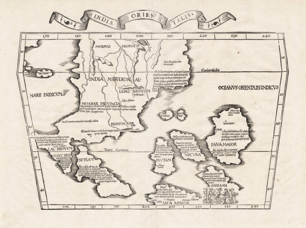
India Orientalis
First Published
Strassburg, 1522
This Edition
Lyon, 1535
Size
28.1 x 43.6 cms
Technique
Condition
mint
Price
$ 4,750.00
(Convert price to other currencies)
Description
A fascinating woodcut map of the South East Asia archipelago, by Laurent Fries. It is the earliest modern map dedicated to the region (as apposed to Ptolemy's map of the region dating back to classical antiquity), and was first published 500 years ago.
The cartographic image is deduced entirely from the 13th century travel account of the Venetian Marco Polo, and many quotes from his book are placed all over the map.
A cannibal barbecue feast is depicted at the lower right, with a reference to the Andaman islands. The natives are depicted wearing Medieval European clothes.
While nearly all of the maps in Fries' atlas are reduced versions of the maps in Martin Waldseemüller's 1513 edition of Ptolemy's Geographia, this map here is one of the very few exceptions of a map that has no corresponding progenitor in the 1513 atlas.
For this map, the geographical content, as well as the text legends on the map, closely follow the cartography of Southeast Asia on Waldseemüller's 1507 wall map of the world.
On his 1507 map, Martin Waldseemüller has closely adopted the cartography and the corresponding text legends for Southeast Asia from one of the world maps by Henricus Martellus Germanus, a map that is presumably lost but which must have been very close to Yale's famous manuscript map of the world of ca 1491.
Interestingly, a version of Germanus' map of the world was also closely copied by Martin Behaim to construct his Erdapfel of 1492, the oldest surviving globe.
As a side note, there is very little doubt that Christopher Columbus was familiar with Martellus' new cartography of the world and used it to plan and navigate his voyages.
Condition
Here from the 1535 Lyons edition, with the decorative title banner on top and blank verso. A strong and even imprint of the woodblock. Thick and clean paper, with no restorations or imperfections. A pristine collector's example.
The text legends on the map
For detailed transcriptions and translations of the Latin text legends on this map, as well as the sources for them, please do not hesitate to ask us.
Laurent Fries (c.1490-c.1532)
Laurent Fries (Laurentius Frisius), born in Mulhouse in Burgundy, travelled widely, studying as a physician and mathematician in Vienne, Padua, Montpellier and Colmar before settling in Strassburg. There he is first heard of working as a draughtsman on Peter Apian's highly decorative cordiform World Map, published in 1520. Apian’s map was based on Waldseemüller's map of 1507 which no doubt inspired Fries's interest in the Waldseemüller Ptolemy atlases of 1513 and 1520 and brought him into contact with the publisher, Johannes Grüninger. It is thought that Grüninger had acquired the woodcuts of the 1520 edition with the intention of producing a new version to be edited by Fries. Under his direction the maps were redrawn and although many of them were unchanged, except for size, others were embellished with historical notes and figures, legends and the occasional sea monster. Three new maps were added.
There were four editions of Fries' reduced sized re-issue of Waldseemüller's Ptolemy atlas:
1522 Strassburg: 50 woodcut maps, reduced in size, revised by Laurent Fries (Laurentius Frisius) and included the earliest map showing the name ‘America' which is likely to be available to collectors
1525 Strassburg: re-issue of 1522 maps
1535 Lyon: re-issue of 1522 maps, edited by Michael Servetus who was subsequently tried for heresy and burned at the stake in 1553, ostensibly because of derogatory comments in the atlas about the Holy Land – the fact that the notes in question had not even been written by Servetus, but were copied from earlier editions, left his Calvinist persecutors unmoved
1541 Vienne (Dauphiné): re-issue of the Lyon edition - the offensive comments about the Holy Land have been deleted
(Moreland and Bannister)
Martin Waldseemüller (c.1470-1518)
Waldseemüller, born in Radolfzell, a village on what is now the Swiss shore of Lake Constance, studied for the church at Freiburg and eventually settled in St Dié at the Court of the Duke of Lorraine, at that time a noted patron of the arts. There, in the company of likeminded savants, he devoted himself to a study of cartography and cosmography, the outcome of which was a world map on 12 sheets, now famous as the map on which the name “America’ appears for the first time. Suggested by Waldseemüller in honour of Amerigo Vespucci (latinised: Americus Vesputius) whom he regarded, quite inexplicably, as the discoverer of the New World, the new name became generally accepted by geographers before the error could be rectified, and its use was endorsed by Mercator on his world map printed in 1538. Although only one copy is now known of Waldseemüller's map and of the later Carta Marina (1516) they were extensively copied in various forms by other cartographers of the day.
Waldseemüller is best known for his preparation from about 1507 onwards of the maps for an issue of Ptolemy's Geographia, now regarded as the most important edition of that work. Published by other hands in Strassburg in 1513, it included 20 ‘modern' maps and passed through one other edition in 1520. Four more editions on reduced size were issued of the Laurent Fries version.
It remained the most authoritative work of its time until the issue of Münster's Geographia in 1540 and Cosmographia in 1544.
(Moreland and Bannister)


