Leen Helmink Antique Maps
Complete set of the Coronelli's nine maps of China
Stock number: 19975
Zoom ImageCartographer(s)
Vincenzo Maria Coronelli (biography)
Title
[Complete Set of Coronelli’s Maps of China]
First Published
Venice, 1688
Size
62 x 46 (9x) cms
Technique
Condition
excellent
Price
$ 12,500.00
(Convert price to other currencies)
Description
Complete Set of Coronelli’s Maps of China.
Venice, c. 1688–1695.
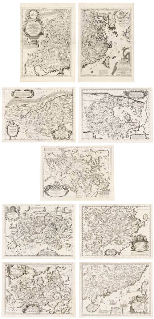
Complete set of nine large engraved maps consisting of the two-sheet general medium size wall map of China (Parte Occidentale della China and Parte Orientale della China) together with the seven regional maps of the Chinese provinces.
Each sheet approximately 460 × 620 mm (18 × 24½ inches).
An exceptionally fine and complete set of one of the most elaborate and sought-after seventeenth-century cartographic portrayals of China. Coronelli’s maps combine the best available Jesuit geographical intelligence with the highly ornamental style for which the Venetian cosmographer is celebrated.
The two-sheet overview covers the whole of China and the Korean peninsula, extending north to the Great Wall (with lengthy descriptive notes on its length, construction and fortifications), and including Formosa (Taiwan, with historical notes on Dutch occupation and Coxinga), northern Hainan, and the principal coastal and interior features. Cities appear under contemporary European forms (Peking as Xuntien, Shanghai as Xanghei, etc.), provinces are clearly delineated, and rivers, lakes, canals, mountains, deserts, fortresses and towns are rendered in rich detail. The sheets are richly adorned with cartouches containing scientific and navigational instruments (compasses, quadrants, dividers, scales), the Jesuit IHS monogram, and further dedicatory elements, all visual tributes to the surveying and mathematical skills of the Jesuit missionaries whose reports formed the primary source material.
The two-sheet general map is dedicated to Antonio Baldigiani (1647–1711), the Jesuit who succeeded Athanasius Kircher as professor of mathematics at the Collegio Romano and who, from 1691, advised the Congregation of the Index, a significant conduit between the new science and the Church. In place of the usual armorial, the cartouche therefore carries the IHS monogram of the Society of Jesus.
1- Parte Occidentale della China, Divisa nelle sue Provincie…
2- Parte Orientale della China, Divisa nelle sue Provincie…
This general map in two sheets follows French models closely, above all Philippe Couplet's of 1687, so closely that the Yellow River retains its French form, "Jaune F.", rather than being Italianised. Beneath the title cartouche Coronelli reproduces Couplet's statistics: fifteen provinces, 155 metropolitan cities, 1,312 subordinate cities, over 2,357 fortified castles, and a population returned by Couplet at more than 58 million.
The seven accompanying regional maps treat pairs (or small groups) of provinces in greater detail:
3- Xansi, e Xensi Provincie … (Shanxi and Shaanxi)
4- Xantung, e Peking Provincie … (Shandong and Zhili)
5- Nanking, et Honan Provincie … (Jiangnan and Henan)
6- Hounang, e Sucuhen Provincie … (Huguang and Sichuan)
7- Chekiang, e Kiangsi Provincie … (Zhejiang and Jiangxi)
8- Unanqueichev, e Quangsi Provincie … (Yunnan, Guizhou and Guangxi)
9- Quantung, e Fokien Provincie … (Guangdong and Fujian)
Each regional sheet carries its own elaborate title cartouche, often with a coat of arms or dedication to a Venetian senator, Jesuit, or other notable, and is similarly embellished with instruments and decorative motifs.
The maps draw closely on Jesuit sources, notably the surveys and publications associated with Martino Martini. They first appeared as loose sheets (the general map as early as July 1688 according to Milanesi) and were subsequently incorporated into Coronelli’s Corso geografico universale (and related publications such as the Atlante Veneto).
Vincenzo Maria Coronelli (1650–1718), Minorite friar, cosmographer to the Republic of Venice and founder of the Accademia degli Argonauti, was one of the outstanding mapmakers and globe-makers of his age. His access to Jesuit networks, combined with his workshop’s superb engraving, produced maps that remain among the most visually striking and geographically informative Western depictions of China from the late seventeenth century.
Coronelli's China is among the most ambitious regional projects of his career, and the set is seldom found entire. A complete set of this quality is uncommon on the market.
Literature
Marco Caboara, Regnum Chinae: The Printed Western Maps of China to 1735, no. 96, pp. 409–413.
Armao, Vincenzo Coronelli.
Marica Milanesi, Vincenzo Coronelli Cosmographer (1650–1718), pp. 211–215, 396.
Condition description
Excellent condition.
Vincenzo Maria Coronelli (1650-1718)
Ordained as a Franciscan priest, Coronelli spent of his life in Venice, becoming a noted theologian an being appointed, in 1699, Father General of his order. By that time he was already famous as a mathematician cartographer and globe maker and his influence led to a revival of interest in these subjects in Italy at the end of the seventeenth century. He was certainly the greatest cartographer of his time there and became Cosmographer to the Venetian Republic, taught geography in the University and, in 1680, founded the first geographical society, the Academia Cosmografica degli Argonauti.
In his lifetime he compiled and engraved over 500 maps including a large 2-volume work, the Atlante Veneto, somewhat reminiscent of Robert Dudley's Dell' Arcano del Mare; he is equally well known for his construction of very large terrestrial and celestial globes even finer than those of Blaeu, including one, 15 feet in diameter, made for Louis XIV of France.
(Moreland and Bannister)
Related Categories
Related Items