Leen Helmink Antique Maps
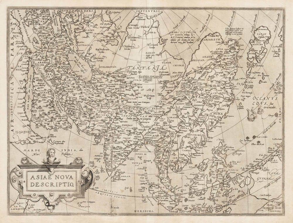
First state of Ortelius' map of Asia
The item below has been sold, but if you enter your email address we will notify you in case we have another example that is not yet listed or as soon as we receive another example.

Stock number: 19839
Zoom ImageCartographer(s)
Abraham Ortelius (biography)
Title
Asiae Nova Descriptio
First Published
Antwerp, 1570
Size
37.2 x 59.6 cms
Technique
Condition
excellent
Price
This Item is Sold
Description
Rare first state of Ortelius's cornerstone map of Asia, from the 1570 Latin (B or C) edition.
Ortelius influential map of Asia after Gastaldi.
This map appeared in the first edition of Abraham Ortelius's em>Theatrum Orbis Terrarum, published in Antwerp on 20 May 1570, widely regarded as the first modern atlas. The "Asiae Nova Descriptio" represents one of the most influential sixteenth-century depictions of Asia and remained in use, with periodic updates to the plate, through subsequent editions of the Theatrum into the early seventeenth century.
The map encompasses the entire Asian continent from the Mediterranean and the Nile Delta in the west to Japan (Iapan) and the nascent delineation of the northwest coast of the Americas in the east. It extends from Nova Zembla and the Arctic regions in the north to the Indonesian archipelago and parts of New Guinea in the south. The Indian subcontinent is depicted in its characteristic elongated, peninsular form typical of Ptolemaic-influenced cartography, though updated with Portuguese navigational data. The Malay Peninsula (Malacca) is prominently rendered, as are the islands of Sumatra, Borneo, Java, and the Moluccas, reflecting the intense European commercial interest in the Spice Islands.
The cartographic depiction of Southeast and East Asia draws heavily on the Portuguese portolan tradition and the manuscript charts circulating among Iberian navigators, supplemented by the influential maps of Giacomo Gastaldi and Gerard Mercator. China (China) is shown with a largely speculative interior, while the Korean Peninsula typically appears as an island or is absent altogether. Japan is rendered as an elongated, roughly north–south oriented island, following Marco Polo's account and the early Jesuit reports that had begun filtering into European geographical knowledge.
Central Asia is filled with mountain ranges, notably the Imaus (a classical reference to the Himalayas and associated ranges), along with references to Tartaria and the Silk Road caravan routes. Arabia (Arabia Felix, Arabia Deserta, Arabia Petraea) follows classical Ptolemaic divisions. The Caspian Sea is depicted in its characteristic east–west elongated form, a persistent cartographic convention not corrected until the eighteenth century.
The map is richly ornamented in the Flemish Renaissance style characteristic of Ortelius's workshop. The title is set within an elaborate strapwork cartouche, typically located in the upper portion of the map. The seas are enlivened with sailing vessels and sea monsters, reflecting the conventions of the period and underscoring the maritime character of European engagement with Asia.
Ortelius, as a compiler rather than a surveyor, synthesized the best available geographical information from a range of sources. For Asia, his principal models included Gastaldi's wall map of Asia (1559), Mercator's world map of 1569, and the accumulated Portuguese and Spanish navigational intelligence accessible through the Iberian cartographic networks. Ortelius was notable for his scholarly integrity in acknowledging his sources, listing contributing cartographers in the Catalogus Auctorum appended to the Theatrum.
he map appeared in all Latin, Dutch, German, French, Spanish, Italian, and English editions of the Theatrum from 1570 onwards. The plate was updated periodically, and bibliographers distinguish several states based on changes to the text on the verso, plate modifications, and the evolving content of the atlas itself. Marcel van den Broecke's Ortelius Atlas Maps (2011) provides a comprehensive census of states and editions.
The "Asiae Nova Descriptio" is a foundational map in the European cartographic understanding of Asia. As part of the first systematically organized atlas, it standardized a visual image of the continent that was widely disseminated and enormously influential. The map captures a transitional moment in geographical knowledge, bridging classical Ptolemaic geography, medieval accounts such as those of Marco Polo, and the emerging empirical data generated by the Portuguese Estado da Índia and the nascent Spanish presence in the Philippines. It remains an essential reference point for the study of sixteenth-century European perceptions of Asia.
The verso Latin text translates as follows:
ASIA
Asia is separated from Europe by the river Tanais [Don], and by a line drawn from its sources to the Bay of Grandvicum [Barents Sea / White Sea region] in the Northern Ocean; from Africa, by the isthmus that lies between the Mediterranean Sea and the Arabian Gulf [Red Sea]. The remainder is surrounded by the ocean and by seas.
The ancients divided it in many ways; but today it seems to us that it may not inappropriately be divided into five parts, according to the empires by which it is governed.
The first part, which is adjacent to Europe and subject to the Grand Duke of Muscovy, is bounded by the Frozen Sea [Mare Glaciale], the river Ob, Lake Kitaia, and a line drawn thence to the Caspian Sea, and by the isthmus between that sea and the Black Sea [Pontus Euxinus].
The second will be that which obeys the Great Khan [Magnus Chamus], Emperor of the Tartars; whose boundaries on the south are the Caspian Sea, the river Iaxartes [Syr Darya], and Mount Imaus [Himalayas]; on the east and north, the ocean; on the west, the already mentioned kingdom of the Duke of Muscovy.
The third part the dynasty of the Ottomans occupies, and it contains whatever lands are situated within the Black Sea, the Aegean Sea (now called the Archipelago) and the Mediterranean, Egypt, the Arabian and Persian Gulfs, the river Tigris, the Caspian Sea, and the isthmus that is to be found between this [sea] and the Black Sea.
Under the fourth is comprised the kingdom of Persia, which today is governed by the Sophis [Safavid dynasty]; it has the Ottomans (with whom it wages almost continual war) on the west; the kingdom of the Great Khan on the north; and it extends eastward almost to the river Indus; on the south it is washed by the sea which today is called the Indian [Ocean], but was formerly called the Red [Sea].
The fifth part will comprise the remainder, which they call the Indies now, as also in former times; which is governed not by a single ruler, as the others, but by many petty kings (for nearly every region of that [part] has its own prince, some of whom are even tributaries to the Great Khan).
But neither should this be passed over: that the maritime places from the Arabian Gulf [Red Sea] all the way to the promontory commonly called Cabo de Lampo (which you see at the 30th degree of northern latitude) are nearly all possessed by the Portuguese, or have been made tributary to them.
Strabo treats this Asia in six books, beginning from the eleventh. Ptolemy described it in three books — the fifth, sixth, and seventh — and likewise in twelve maps, assigning forty provinces to it. Of the modern writers, no one has described it in its entirety in detail. Marcus Paulus Venetus [Marco Polo], Ludovicus Vartomannus [Ludovico di Varthema], and Joannes Mandevile (but this last is full of fables) committed to writing only as much about it as they found worthy of knowing by travelling through its regions. See also the epistle of Jacobus Navarchus [ship's captain], a Jesuit.
We have also published a large wall map of Asia three years ago.
Abraham Ortelius (1527-1598)
Abraham Ortelius is the most famous and most collected of all early cartographers. In 1570 he published the first comprehensive collection of maps of all parts of the world, the Theatrum Orbis Terrarum ("Theatre of the World"), the first modern atlas as we know it.
"Abraham Ortel, better known as Ortelius, was born in Antwerp and after studying Greek, Latin and mathematics set up business there with his sister, as a book dealer and ‘painter of maps'. Traveling widely, especially to the great book fairs, his business prospered and he established contacts with the literati in many lands. On one such visit to England, possibly seeking temporary refuge from religious persecution, he met William Camden whom he is said to have encouraged in the production of the Britannia.
A turning point in his career was reached in 1564 with the publication of a World Map in eight sheets of which only one copy is known: other individual maps followed and then – at the suggestion of a friend - he gathered together a collection of maps from contacts among European cartographers and had them engraved in uniform size and issued in 1570 as the Theatrum Orbis Terrarum (Atlas of the Whole World). Although Lafreri and others in Italy had published collections of ‘modern' maps in book form in earlier years, the Theatrum was the first uniformly sized, systematic collection of maps and hence can be called the first atlas, although that term itself was not used until twenty years later by Mercator.
The Theatrum, with most of its maps elegantly engraved by Frans Hogenberg, was an instant success and appeared in numerous editions in different languages including addenda issued from time to time incorporating the latest contemporary knowledge and discoveries. The final edition appeared in 1612. Unlike many of his contemporaries Ortelius noted his sources of information and in the first edition acknowledgement was made to eighty-seven different cartographers.
Apart from the modern maps in his major atlas, Ortelius himself compiled a series of historical maps known as the Parergon Theatri which appeared from 1579 onwards, sometimes as a separate publication and sometimes incorporated in the Theatrum."
(Moreland and Bannister)
"The maker of the ‘first atlas', the Theatrum Orbis Terrarum (1570), started his career as a colorist of maps. Later, he became a seller of books, prints and maps. His scientific and collecting interests developed in harmony with those of a merchant. He was first and foremost a historian. Geography for him was the ‘eye of history', which may explain why, in addition to coins and historical objects, he also collected maps. On the basis of his extensive travels through Europe and with the help of his international circle of friends, Ortelius was able to build a collection of the most up-to-date maps available.
The unique position held by Ortelius's Theatrum in the history of cartography is to be attributed primarily to its qualification as ‘the world's first regularly produced atlas.' Its great commercial success enabled it to make a great contribution to ‘geographical culture' throughout Europe at the end of the sixteenth century. Shape and contents set the standard for later atlases, when the centre of the map trade moved from Antwerp to Amsterdam. The characteristic feature of the Theatrum is that it consists of two elements, text and maps. Another important aspect is that it was the first undertaking of its kind to reduce the best available maps to a uniform format. To that end, maps of various formats and styles had to be generalized just like the modern atlas publisher of today would do. In selecting maps for his compilation, Ortelius was guided by his critical spirit and his encyclopaedic knowledge of maps. But Ortelius did more than the present atlas makers: he mentioned the names of the authors of the original maps and added the names of many other cartographers and geographers to his list. This ‘catalogus auctorum tabularum geographicum,' printed in the Theatrum, is one of the major peculiarities of the atlas. Ortelius and his successors kept his list of map authors up-to-date. In the first edition of 1570 the list included 87 names. In the posthumous edition of 1603, it contained 183 names.
Abraham Ortelius himself drew all his maps in manuscript before passing them to the engravers. In the preface to the Theatrum he stated that all the plates were engraved by Frans Hogenberg, who probably was assisted by Ambrosius and Ferdinand Arsenius (= Aertsen). The first edition of the Theatrum is dated 20 May 1570 and includes 53 maps.
The Theatrum was printed at Ortelius's expense first by Gielis Coppens van Diest, an Antwerp printer who had experience with printing cosmographical works. From 1539 onwards, Van Diest had printed various editions of Apianus's Cosmographia, edited by Gemma Frisius, and in 1552 he printed Honterus's Rudimentorum Cosmograhicorum... Libri IIII. Gielis Coppens van Diest was succeeded as printer of the Theatrum in 1573 by his son Anthonis, who in turn was followed by Gillis van den Rade, who printed the 1575 edition. From 1579 onwards Christoffel Plantin printed the Theatrum, still at Ortelius's own expense. Plantin and later his successors continued printing the work until Ortelius's heirs sold the copperplates and the publication rights in 1601 to Jan Baptist Vrients, who added some new maps. After 1612, the year of Vrients's death, the copperplates passed to the Moretus brothers, the successors of Christoffel Plantin.
The editions of the Theatrum may be subdivided into five groups on the basis of the number of maps. The first group contains 53 maps, 18 maps were added. The second group has 70 maps (one of the 18 new maps replaced a previous one). In 1579 another expansion was issued with 23 maps. Some maps replaced older ones, so as of that date the Theatrum contained 112. In 1590 a fourth addition followed with 22 maps. The editions then had 134 maps. A final, fifth expansion with 17 maps followed in 1595, bringing the total to 151."
(Peter van der Krogt, Atlantes Neerlandici New Edition, Volume III)
Related Categories
Related Items


