Leen Helmink Antique Maps
Old Master Print of the Allegory of China - Atlas Maior frontispiece by Joan Blaeu

Stock number: 18855
Zoom ImageCartographer(s)
Joan Blaeu (biography)
Title
Novus Atlas Sinensis a Martino Martinio
First Published
Amsterdam, 1655
This Edition
1662
Size
44.5 x 30.5 cms
Technique
Condition
excellent
Price
$ 2,750.00
(Convert price to other currencies)
Description
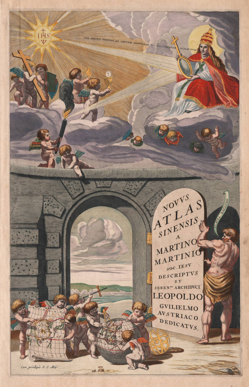
Magnificent Atlas Maior allegorical frontispiece of Asia, depicting the Great Wall of China. Rare.
This example in stunning colour, heightened in gold.
"Joan Blaeu was the son and successor of the great globe, instrument, and atlas-maker Willem Janszoon Blaeu. After the death of his father in 1638 Joan expanded the family firm's atlas production considerably.
The culmination of their output was the publication of the Atlas Maior (or Grand Atlas) in 1662. In its most complete form the work comprises 11 or 12 parts or volumes and over 600 maps. Earlier atlases from the Blaeu establishment had titlepages centred around an architectural frame. However, for his Grand Atlas, Joan Blaeu broke away from this somewhat formal tradition and introduced a more pictorial composition as a general frontispiece, coupled with a typographic titlepage. There were five further frontispieces for the continental sections: Europe, Africa, America, Asia and Arctica.
Examples of Blaeu's main frontispiece were used for all impressions of his Atlas Maior throughout the 1660s. The continental frontispieces, however, are not found in all editions and thus in some cases they are quite rare.
For the other major continent described in his Grand Atlas, Asia, Blaeu used a striking new adaptation of a titlepage that had first appeared in 1655 for the maps of China and Japan in Part VI of his Novus Atlas. The Chinese maps were originated by Martino Martini, a Jesuit missionary working in China, and formed the largest part of volume XI of Blaeu's Grand Atlas devoted to Asia.
In the lower part of the frontispiece, an open portal is revealed by means of a large door. In the foreground several putti unroll part of a map of China and also cluster around a globe whereon measurements are being made. The upper part of the titlepage is a complex symbolic piece upholding the activities of the Jesuit missionaries in the Far East. Light from a radiant starry emblem of Jesus Christ (IHS) on the left is reflected by a mirror without stain (Speculum Sine Macula) held by a youthful looking Pope (actually, at that time, Alexander VII) and from there transmitted to light a beacon held by a putto atop the central dividing wall. The longer quotation from Isaiah 18.2 uttering from the mouth of the Pope translates as 'Go, swift messengers, to a nation powerful but divided'. Thus the messages of the Gospel are sent out to reach those hitherto in darkness. Additionally within the top picture several putti hold emblems of the Word — a crucifix, a book (implicitly the New Testament) and vessels associated with the Eucharist.
In an earlier version —volume VI of Blaeu's Novus Atlas of 1655— a similar titlepage showed a larger massive arch with a top portico on pillars instead of the heavenly Jesuit scene. The view through the portal is of a different landscape, with a castle on a hill and a fortified town in the distance. The two groups of putti in the foreground are however the same."
(Shirley).
"Joan Blaeu had designed and engraved for his Atlas Maior a series of five allegorical title pages: a general one for the atlas as a whole, and four for the continents Arctic, Europe, Africa, and America. For Asia a different title page was used, based on the title page of the Atlas Sinensis.
The design for these plates was probably by Nicolaes van Berchem (1620-1683) and they were engraved by Cornelis van Dalen, Jeremias Falck, and Johannes Visscher.
Except for the general title page, those prints were not used for all atlases.
(van der Krogt).
"Blaeu's title pages are symbolic or allegoric in form, depicting images either derived from classical antecedents or based in an allusive way on the atlas contents."
(van der Krogt)
THE [BLAEU] ATLAS OF CHINA
The publication of the atlas of China seems to owe more to coincidence than to planning. In 1654, in the foreword to the Dutch edition of the atlas of Scotland, Joan Blaeu announced that he was preparing town books of Italy, a volume of charts, and a volume of historical maps, and that these were delayed. But while he was working on these volumes, wrote Blaeu, Father Martinus Martini had come from the Indies, bringing with him his sketches and descriptions of the Chinese empire. Martini persisted in his attempt to have Blaeu engrave and publish these, so Blaeu postponed the work on the other volumes to prepare the atlas of China, and published it about a year later.
Martinus Martini (1614-1661) began working in 1642 as a Jesuit missionary in various provinces of China. When he was ordered to Rome in 1651, he took with him more than 50 Chinese books and maps, among them a copy of the manuscript atlas of the Chinese provinces by Zhu Siben, compiled in 1311/12, with revisions from the printed atlas by Lo Hongxian (1555). Martini's ship was captured by the Dutch and brought to Java. Martini was sent to Amsterdam where he arrived in 1654. During the voyage to Europe aboard the Dutch East-Indiamen, Martini made a Latin translation of the text and wrote his own description of China. In 1659, Joan Blaeu published the Latin translation, titled "Sinicae historiae decas prima", separately without maps. The text in Blaeu's atlas of China is Martini's own account, written in the first person, of the geography and history, the manners and customs of the Chinese empire and its peoples.
Martini's atlas of China includes the following parts:
1. A lengthy preface by Martinus Martini with an explanation of how he compiled his maps from the Chinese originals.
2. A general map of China (map 1).
3. A geographical description of the 15 provinces of China, each description preceded by a map of that province (maps 2-16).
4. A geographical description of Japan with a map (map 17).
5. The “Catalogus Longitudinum ac Latitudinem,” a list of towns with their geographical co-ordinates.
6. A supplement to the geographical description by Jacob Golius, “De Regno Catayo Additamentum Iacobus Golius Lectori.”
7. A history of the Manshu War by Martinus Martini, “De Bello Tartarico Historia " originally published in 1654 in Antwerp, with an additional letter by Francisco Brancaro from Shanghai, 14 November 1651.
The atlas of China was published by Joan Blaeu in five different languages: Latin, French, Dutch, German, and Spanish. It was published separately and added as the sixth volume to the Theatrum Orbis Terrarum, the only difference being in the engraved title page. Title page 2:26A, which was used for the Theatrum edition, has a blank panel for the letterpress volume title. The second title page, 2:26B, was used for the separate editions of the atlas. Both title pages have the title of the atlas and the name of the author in Latin, but, strangely enough, the name of the publisher does not appear on the title page or anywhere else in the volume. In several libraries, therefore, the atlas of China is not recognized as a Blaeu atlas.
The volume was later bound up with the other maps and text of Asia to form the Asia volume of the Atlas Maior.
(van der Krogt)
Willem Janszoon Blaeu (1571-1638)
Joan Blaeu (son) (1596-1673)
Cornelis Blaeu (son) (?-c.1642)
Willem Janszoon Blaeu died in October 1638, leaving his prospering business to his sons, Joan and Cornelis, who continued and expanded their father's ambitious plans.
After the premature death of his brother Cornelis in 1642, Joan directed the work alone and the whole atlas series of 6 volumes was eventually completed about 1655. As soon as it was finished he began the preparation of the even larger work, the Atlas Maior, which reached publication in 1662 in 11 volumes (later editions in 9-12 volumes) and contained nearly 600 double-page maps and 3,000 pages of text. This was, and indeed remains, the most magnificent work of its kind ever produced; perhaps its geographical content was not as up-to-date or as accurate as its author could have wished, but any deficiencies in that direction were more than compensated for by the fine engraving and colouring, the elaborate cartouches and pictorial and heraldic detail and especially the splendid calligraphy.
In 1672 a disastrous fire destroyed Blaeu's printing house in the Gravenstraat and a year afterwards Joan Blaeu died. The firm's surviving stocks of plates and maps were gradually dispersed, some of the plates being bought by F. de Wit and Schenk and Valck, before final closure in about 1695.
(Moreland and Bannister)
Related Categories
Related Items


