Leen Helmink Antique Maps
Antique map of Denmark by Johannes Janssonius

Stock number: 19831
Zoom ImageCartographer(s)
Johannes Janssonius
Title
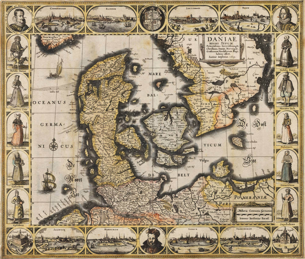
Daniae Regni Typum
First Published
Amsterdam, 1629
This Edition
1629 first state
Size
41.5 x 50.5 cm (plate size) cms
Condition
excellent
Price
$ 1,850.00
(Convert price to other currencies)
Description
This meticulously engraved map represents one of the earliest substantial cartographic depictions of Denmark produced by the esteemed Amsterdam-based publisher Johannes Janssonius. Titled 'Daniae Regni Typum,' it portrays the Kingdom of Denmark encompassing the Jutland peninsula, the major islands of Zealand, Funen, and Lolland-Falster, as well as southern Sweden up to Scania and parts of Norway. The map is oriented with north at the top, employing a scale of approximately 1:1,800,000, which allows for a balanced view of the region's geography.
The topography is indicated through hachuring, denoting elevations in Jutland and adjacent areas, while hydrography is richly detailed with rivers, fjords, and the intricate coastlines of the Baltic Sea and Kattegat. Principal towns such as Copenhagen (Hafnia), Helsingør (Elsinorum), and Aarhus are prominently marked and illustrated with small pictorial vignettes, reflecting their significance. The map incorporates rhumb lines emanating from compass roses, aiding navigation, and includes a latitude scale along the right margin.
Cartographic sources likely draw from Danish surveys and earlier works by Mercator and Ortelius, updated with contemporary observations. Janssonius, building on his apprenticeship under Pieter van den Keere, demonstrates advanced engraving techniques, evident in the fine lines and intricate detailing. The map's first state, dated 1629, precedes its inclusion in later atlases, making it a pivotal piece in the evolution of Scandinavian cartography during the Dutch Golden Age.
Borders feature scale bars in German, Danish, and Dutch miles, underscoring the map's utility for diverse audiences. The condition of surviving examples varies, but this specimen retains vibrant original wash colouring, enhancing the visual distinction between land, sea, and urban centers. Scholarly analysis, as noted in catalogues from institutions like the British Library and David Rumsey Map Collection, highlights its accuracy relative to predecessors, particularly in delineating the Danish Sound and island configurations.
In the broader context of 17th-century map production, this work exemplifies the shift towards more precise regional mapping, influenced by increased maritime trade and political interests in the Baltic region. References in auction records from Old World Auctions and Bartele Gallery confirm its scarcity in early states, with impressions valued for their historical insight into pre-Thirty Years' War geopolitics. Comparative studies with Blaeu's contemporaneous maps reveal Janssonius' competitive edge in detail and aesthetics.
Related Categories


