Leen Helmink Antique Maps
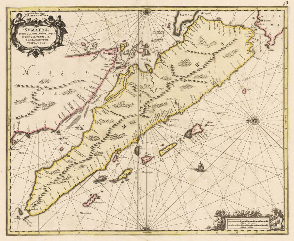
Antique sea chart of Sumatra, Malaysia and Singapore by Janssonius
The item below has been sold, but if you enter your email address we will notify you in case we have another example that is not yet listed or as soon as we receive another example.
Stock number: 19817
Zoom ImageCartographer(s)
Johannes Janssonius (biography)
Title
Sumatrae et Insularum Locorumque Nonnullorum Circumiacentium Tabula Nova.
First Published
Amsterdam, 1659
This Edition
1700 Schenk and Valck
Size
42.5 x 52.0 cms
Technique
Condition
excellent
Price
This Item is Sold
Description
Very attractive collector's example of this well executed sea chart.
The first printed sea chart of Sumatra and the Strait of Malacca, by the great Amsterdam publisher Johannes Janssonius (1588-1664).
The title, in a strapwork cartouche at the upper left, reads Sumatrae et insularum locorumque nonnullorum circumiacentium tabula nova (a new chart of Sumatra and of certain islands and places lying about it).
The chart is oriented with east at the top. As a sea-chart it is focused on the coast, with the shoreline is closely drawn and named, while the interior of the great island is left blank, knowledge of it being of no use to the navigator and all but unknown to Europeans, whose contact was confined to the trading ports of the coast.
the convention of a working sea-chart following the coast, and the long axis of Sumatra runs across the sheet and the Malay Peninsula, with Malacca above it; the Strait of Malacca, the great artery between the Indian Ocean and the South China Sea, and one of the most strategic passages in all the East, divides the two.
The chart is based on the most recent manuscript navigation charts the Dutch East India Company. It is handsomely engraved, embellished with strapwork cartouches and putti, and with scale-bars of Dutch and French (old) nautical miles.
Janssonius was the great rival of the Blaeu house; his maritime atlas, the Waterwereld, formed the first part of Volume V of his composite Atlas Novus, and was the first sea-atlas in the modern sense. This chart of Borneo, with its companions of Java and Borneo, was not part of the founding edition of 1650 (whose Asian content was only four charts) but was introduced into the Waterwereld with the Latin edition of 1659.
The present impression is the later state issued about 1700 by Pieter Schenk and Gerard Valk, who acquired the plate among the dispersed Janssonius stock. A classic and decorative sea-chart.
Significance
The first printed sea chart of Sumatra and Malacca Strait, copied from the offical but secret vellum VOC navigation chart of the island.
Condition description
Tiny unobtrusive restoration in centrefold, not affecting the printed area, else pristine. Here is the rare state of ca 1700 by Pieter Schenk and Gerard Valk. Handsome subdued wash colouring, typical of the period.
Johannes Janssonius (1588-1664)
Johannes Janssonius, more commonly known to us as Jan Jansson, was born in Arnhem where his father was a bookseller and publisher (Jan Janszoon the Elder). In 1612 he married the daughter of the cartographer and publisher Jodocus Hondius, and then set up in business in Amsterdam as a book publisher. In 1616 he published his first maps of France and Italy and from then onwards he produced a very large number of maps, perhaps not quite rivalling those of the Blaeu family but running a very close second in quantity and quality. From about 1630 to 1638 he was in partnership with his brother-in-law, Henricus Hondius, issuing further editions of the Mercator/Hondius atlases to which his name was added. On the death of Henricus he took over the business, expanding the atlas still further, until eventually he published an 11-volume "Atlas Major" on a scale similar to Blaeu's "Atlas Maior".
The first full edition of Jansson’s English County Maps was published in 1646 but some years earlier he issued a number of British maps in the Mercator/Hondius/ Jansson series of atlases (1636–44); the maps were printed from newly engraved plates and are different from the later 1646 issue and are now rarely seen. In general appearance Jansson’s maps are very similar to those of Blaeu and, in fact, were often copied from them, but they tend to be more flamboyant and, some think, more decorative.
After Jansson's death his heirs published a number of maps in an "Atlas Contractus" in 1666 and later still many of the plates of his British maps were acquired by Pieter Schenk and Gerard Valck, who published them again in 1683 as separate maps.
(Moreland and Bannister)
Related Categories
Related Items