Leen Helmink Antique Maps
Antique sea chart of Sumatra, Malaysia and Singapore by Janssonius

Stock number: 19817
Zoom ImageCartographer(s)
Johannes Janssonius (biography)
Title
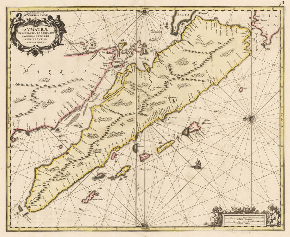
Sumatrae et Insularum Locorumque Nonnullorum Circumiacentium Tabula Nova.
First Published
Amsterdam, 1657
This Edition
1700 Schenk and Valck
Size
42.5 x 52.0 cms
Technique
Condition
excellent
Price
$ 1,250.00
(Convert price to other currencies)
Description
Very attractive collector's example of this well executed sea chart.
Seminal classic Dutch sea chart of Sumatra, Malaysia, Singapore, and the Straits of Malacca, from Janssonius' sea atlas, also known as 'Water-world' and published as Atlas Novus Volume V. East is at the top of the map.
Embellished with strapwork cartouches, putti, and scalebars in Dutch and French (old) nautical miles.
Note that knowledge of the interior is absent, only coastal features and toponyms are given.
Significance
One of the classic Dutch sea charts of the island, based on the latest VOC navigation charts of the region.
Condition description
Tiny unobtrusive restoration in centrefold, not affecting the printed area, else pristine. Here is the rare state of ca 1700 by Pieter Schenk and Gerard Valk. Handsome subdued wash colouring, typical of the period.
Johannes Janssonius (1588-1664)
Johannes Janssonius, more commonly known to us as Jan Jansson, was born in Arnhem where his father was a bookseller and publisher (Jan Janszoon the Elder). In 1612 he married the daughter of the cartographer and publisher Jodocus Hondius, and then set up in business in Amsterdam as a book publisher. In 1616 he published his first maps of France and Italy and from then onwards he produced a very large number of maps, perhaps not quite rivalling those of the Blaeu family but running a very close second in quantity and quality. From about 1630 to 1638 he was in partnership with his brother-in-law, Henricus Hondius, issuing further editions of the Mercator/Hondius atlases to which his name was added. On the death of Henricus he took over the business, expanding the atlas still further, until eventually he published an 11-volume "Atlas Major" on a scale similar to Blaeu's "Atlas Maior".
The first full edition of Jansson’s English County Maps was published in 1646 but some years earlier he issued a number of British maps in the Mercator/Hondius/ Jansson series of atlases (1636–44); the maps were printed from newly engraved plates and are different from the later 1646 issue and are now rarely seen. In general appearance Jansson’s maps are very similar to those of Blaeu and, in fact, were often copied from them, but they tend to be more flamboyant and, some think, more decorative.
After Jansson's death his heirs published a number of maps in an "Atlas Contractus" in 1666 and later still many of the plates of his British maps were acquired by Pieter Schenk and Gerard Valck, who published them again in 1683 as separate maps.
(Moreland and Bannister)


