Leen Helmink Antique Maps
Antique map of the World by Andrea Bianco / Vincenzo Formaleoni
The item below has been sold, but if you enter your email address we will notify you in case we have another example that is not yet listed or as soon as we receive another example.

Stock number: 19751
Zoom ImageCartographer(s)
Andrea Bianco / Vincenzo Formaleoni
Title
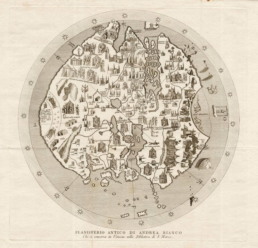
Planisfero Antico di Andrea Bianco Che si conserva in Venezia nella Biblioteca di S. Marco.
First Published
Venice, 1783
Size
25 x 25 cms
Technique
Condition
mint
Price
This Item is Sold
Description
Fine and decorative early presentation of Andrea Bianco's circular world map of 1436, kept in the Bibliotheca Marciana in Venice. It is considered to be the first extant cartographic work depicting the Portuguese discovery of Cape Verde.
This copper engraved version from the first 1783 Italian edition by Vincenzio Antonio Formaleoni's (1752-1797) "Saggio sulla nautica antica de' Veneziani ". The map orientation is rotated 90 degrees anti-clockwise. North is to the left.
One aspect of the geographical renaissance of the fifteenth century was the dissemination of Ptolemy's Geography, in numerous editions, to which new maps were continually added to illustrate new insights.
At the top of the map, in eastern Asia, paradise is depicted, as well as Gog and Magog, emperor Kublai Khan, and a wide range of mythical creatures. A sea route is shown to the Indies, around Africa, long before Diaz discovered it. The southeastern Indian Ocean has the ixola perlina (island of pearls).
The map is a schematic "T-O" map of the world, a circle (O) bisected by a T-shape, representing the world surrounded by water and divided into three continents Asia, Europe and Africa. The horizontal part of the "T" symbolizes the Don River (flowing into the Black Sea) and the Nile River, separating Asia from Europe and Africa. The vertical part of the "T" typically represents the Mediterranean Sea, separating Europe from Africa.
This symbolic representation was common in medieval times and held religious significance, with the T representing the cross and the O signifying the world. Jerusalem is placed in the centre of the map, reflecting its spiritual significance in medieval Christianity. T-O maps are often oriented with east at the top, where Asia is placed as it was associated with the Garden of Eden or paradise, and Europe and Africa at the bottom. These regions correspond to the three sons of Noah (Shem, Ham, Japheth) who repopulated the Earth after the Flood.
These medieval maps innovate on the works of the Greco-Roman geography by including new knowledge and new theories, from medieval travellers like Marco Polo to the latest discoveries by the Portuguese. Here, the Portuguese discoveries along the west coast of Africa are shown, and the Gulf of Guinea is more or less correctly drawn, although they had only recently been explored. The tip of Africa has been extended further south than it appears in earlier editions of Ptolemy. These medieval T-O maps accept the theory that the known continents are encircled by one contiguous Ocean, a notion that was advocated by several geographers and historians in antiquity, like Strabo, Eratosthenes, Hecataeus of Miletus, and Herodotus, but that view had been rejected by Ptolemy.
This Italian 18th-century edition of the map is one of the few extant early facsimiles of medieval world maps and is very rare on the market.
Related Categories
Related Items


