Leen Helmink Antique Maps
Antique map of Saint Helena by Linschoten

Stock number: 19441
Zoom ImageCartographer(s)
Jan Huygen van Linschoten (biography)
Title
Insula D.Helenae sacra ... Het Eylant van ...
First Published
Amsterdam, 1596
Size
37.0 x 50.9 cms
Technique
Condition
excellent
Price
$ 850.00
(Convert price to other currencies)
Description
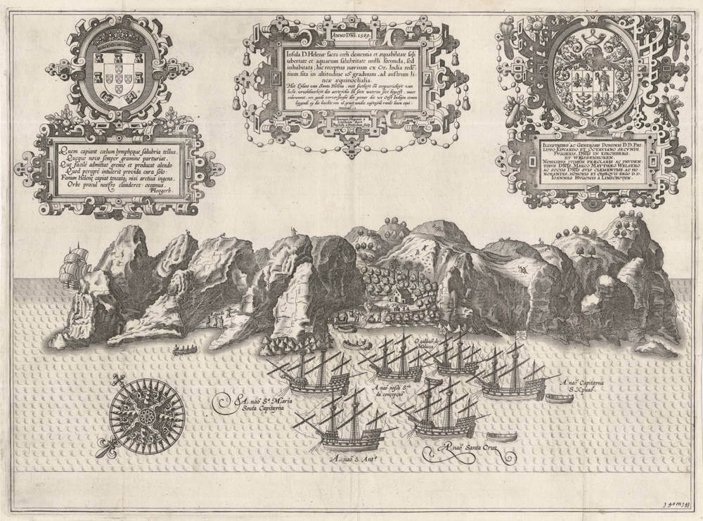
Linschoten's spectacular bird eye's view of the Island of Saint Helena, from his Itinerario.
At the roadstead we see a detailed image of the Portuguese return fleet of 1598 from Goa on its way to Lisbon, with van Linschoten on board. All ships in the fleet are named in this view.
The engraving is signed by Baptista van Doetecum, one of the foremost engravers of the day. It is made after drawings made from life by Linschoten himself, who was a careful observer and documented everything he learned from his years in Portuguese India and the sailing route to and from there.
We see the crew taking in barrels of fresh water. while others are hunting for goats that had been imported their by the Portuguese.
As Linschoten points out in his Itinerario, Saint Helena was a very important stopover for Portuguese fleets to revictual with fresh water, fruits and vegetables and livestock. He also points out that it is easy to overshoot it, because the winds and the waves in the Southern Atlantic are predominantly from Southeast to Northwest, and turning back after missing it was no option.
The print is embellished with three elaborate strapwork cartouches.
Saint Helena Island History of Discovery
According to long-established tradition, the island was sighted on 21 May 1502 by the four ships of the 3rd Portuguese Armada, commanded by João da Nova, a Galician navigator in the service of Portugal, during his return voyage to Lisbon, who named it Santa Helena after Saint Helena of Constantinople.
When Linschoten arrived at the island on 12 May 1589, he reported seeing carvings made by visiting seamen on a fig tree that were dated as early as 1510. The Portuguese probably planted saplings rather than mature trees, and for these to be sufficiently large by 1510 to carry carvings suggests the plants were shipped to the island and planted there some years earlier, possibly within a few years of discovery.
The Portuguese found the island uninhabited, with an abundance of trees and fresh water. They imported livestock, fruit trees, and vegetables, and built a chapel and one or two houses. The long tradition that João da Nova built a chapel from one of his wrecked carracks has been shown to be based on a misreading of the records. They formed no permanent settlement, but the island was an important rendezvous point and source of food for ships travelling by the Cape Route from Asia to Europe, and frequently sick mariners were left on the island to recover before taking passage on the next ship to call at the island.
Englishman Sir Francis Drake probably located the island on the final leg of his circumnavigation of the world (1577–1580). Further visits by other British explorers followed and, once Saint Helena's location was more widely known, British ships of war began to lie in wait in the area to attack Portuguese India carracks on their way home.
In developing their Far East trade, the Dutch also began to frequent the island. The Portuguese and Spanish soon gave up regularly calling at the island, partly because they used ports along the West African coast, but also because of attacks on their shipping, the desecration of their chapel and religious icons, killings of their livestock, and destruction of their plantations by Dutch pirates. The Dutch Republic formally claimed Saint Helena in 1633.
In 1657, Oliver Cromwell granted the East English India Company (EIC) a charter to govern Saint Helena. The following year, the company decided to fortify the island and settle it with planters.[
(Wikipedia)
Jan Huygen van Linschoten (1563-1610)
Jan Huyghen van Linschoten, a Dutchman born in Delft, was secretary to the Portuguese Archbishop in Goa between 1583 and 1589. These experiences were recorded in the Itinerario, which was first published in Dutch (Amsterdam: 1595-1596), and contains the most comprehensive account of the East and West Indies available at the end of the sixteenth century. As well as including important travel accounts from contemporary Portuguese, Dutch and Spanish sources, it is the first work to include precise sailing instructions for the Indies and also includes an account of America.
The Itinerario provided detailed practical information on how to get to and carry on the trade with America and India. The work was indispensible to sailors on the route to the Indies; it provided a dictionary of exotic commodities, of national trading methods, etc. Linschoten’s work, along with Hakluyt’s, served as a direct stimulus to the building of the vast English and Dutch overseas empires. Legend has it that copies were given to every ship sailing to India to use as a log-book, as is confirmed in many surviving ship's journals.
Monumenta Cartographica Neerlandica VII - Jan Huygen van Linschoten and his Itinerario
For the publication of Van Linschoten's Itinerario, Cornelis Claesz did not settle for the thirty-six illustrations that had been exquisitely engraved by the Van Doetecum family. The publisher felt he should spare no expense to make the 'heerlijck werck' [masterly piece], as he called it, as accessible as possible to the readership interested in geography. Therefore, he had a number of 'nette, perfecte caerten' [beautiful and perfect maps] made for his own account. Besides a world map, five detail maps were included in the Itinerario and the Beschryvinghe. The world map is the map by Petrus Plancius that had already been engraved in 1594 by Joannes van Doetecum Jr. and published by Cornelis Claesz. But in some copies of the 1596-99 editions of the Itinerario, this map was replaced by another world map. The substitution was arranged in co-operation with the Antwerp publisher Joan Baptista Vrients and the replacement map was engraved by the Van Langren brothers.
The five detailed maps of Van Linschoten's Itinerario, all of which were engraved by Arnold Floris and Hendrik Floris van Langren, cover a large proportion of the non-European world known at the time. According to the map titles, these detail maps were composed with the aid of the best Portuguese and Spanish charts and rutters. These maps clearly reveal the influence of the set of maps that Cornelis Claesz had already published previously (1592-94), for which Petrus Plancius was responsible. Plancius's maps were copied for inclusion into Van Linschoten's work. These copies differ only in minor details from the originals.
(Günter Schilder)
Antique Maps - A Collector's Guide
Van Linschoten, born in Haarlem, is heard of in the service of the Portuguese Archbishop of Goa where he spent five years between 1583 and 1588.
On his return to Holland he produced a History of his travels, important for the inclusion of maps from Portuguese sources, at that time rarely available to Dutch – or any other – cartographers. The maps (including a world map by Petrus Plancius) engraved by van Langren, are highly decorative with large cartouches, the arms of Portugal, compass roses, rhumb lines and sea monsters. Some are illustrated with views of prominent places or islands.
(Moreland and Bannister)
Related Categories
Related Items


