Leen Helmink Antique Maps
Antique map of Western Australia by Freycinet

Stock number: 19343
Zoom ImageCartographer(s)
Louis de Freycinet (biography)
Title
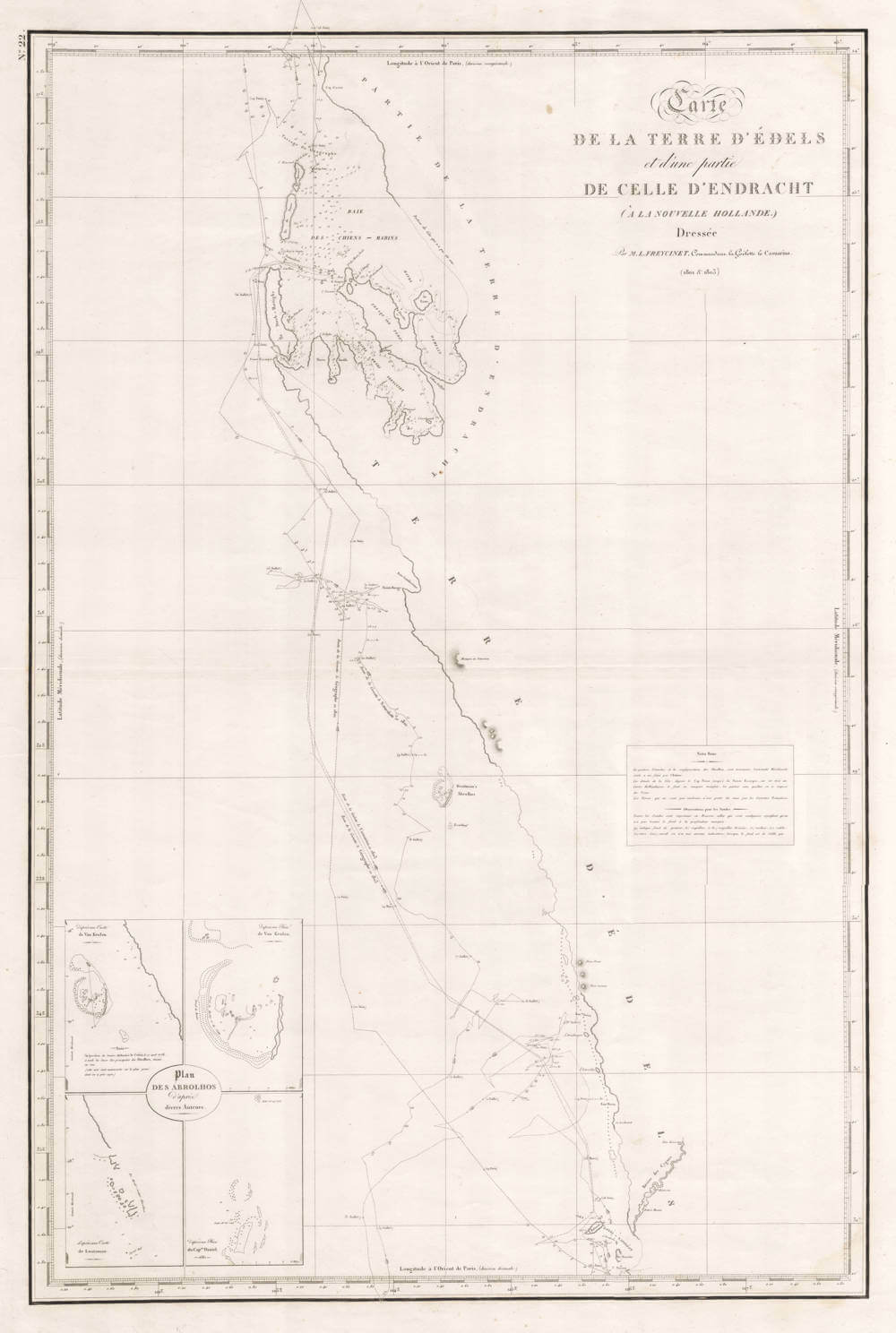
Carte de la Terre D'Edels et d'Une Partie de Celle d'Endracht (a la Nouvelle Hollande)
First Published
Paris, 1812
Size
79.0 x 53.0 cms
Technique
Condition
excellent
Price
This Item is Coming Soon
Description
Louis Claude FREYCINET
CARTE DE LA TERRE D'EDELS 1812
790 x 530 mm
Published in the atlas of 'Voyage De Decouvertes aux Terres Australes', Paris, 1812.
As cartographer on the Baudin voyage, Louis Claude Freycinet drew over 60 maps recording the route taken by Baudin and his men. His intentions to publish an atlas were finally realized in 1812 when the atlas volume of the voyage account finally appeared. This chart comes from that atlas.
Freycinet's chart records part of the coast of Western Australia named after Jacob Dedel, who was the supercargo on Houtman's voyage. Houtman arrived off the coast of Western Australia in the area near the Swan River in July 1619.
Louis de Freycinet (1779-1841)
Louis Claude de Saulces de Freycinet (7 August 1779 – 18 August 1841) was a French Navy officer. He circumnavigated the earth, and in 1811 published the first map to show a full outline of the coastline of Australia.
He was born at Montélimar, Drôme. Louis-Claude de Saulces de Freycinet was his full name (many calling him Louis de Freycinet). He had three brothers, Louis-Henri de Saulces de Freycinet, André-Charles de Saulces de Freycinet and the youngest, Frédéric-Casimir de Saulces de Freycinet (father of Charles de Freycinet). Louis-Claude was the second oldest.
In 1793 he joined the French Navy as a midshipman, and took in several engagements against the British. In 1800, Freycinet was appointed to an exploration expedition to Southern and South-Western coasts of Australia under Nicolas Baudin, on Naturaliste and Géographe. Freycinet's brother, Louis-Henri de Freycinet, was also part of the expedition.
Between September 1802 and August 1803, Freycinet captained the schooner Casuarina, surveying the Australian coastline. He then transferred to Naturaliste, and returned to France in 1804.
Because Matthew Flinders was being held captive by the French on Mauritius, many of his discoveries were revisited and unintendedly claimed by François Péron, and new names were given by this expedition; in 1824 it was remedied in the second edition of Voyage découvertes aux terres australes. In the end, Baudin and Freycinet managed to have their map of the Australian coastline published in 1811, three years before Flinders published his. An inlet on the coast of Western Australia is called Freycinet Estuary. Cape Freycinet between Cape Leeuwin and Cape Naturaliste and the Freycinet Peninsula with Freycinet National Park in Tasmania also bear the explorer's name.
In 1805, he returned to Paris, and was entrusted by the government with the work of preparing the maps and plans of the expedition. He also completed the narrative, and the whole work appeared under the title of Voyage de découvertes aux terres australes (Paris, 1807–1816).
In 1817, he was given command of the corvette Uranie, especially reconfigured to a new exploration voyage. Uranie carried several members of the Navy scientific staff, notably marine hydrologist Louis Isidore Duperrey, artist Jacques Arago, and his junior draughtsman Adrien Taunay the Younger.
Uranie sailed to Rio de Janeiro to take a series of pendulum measurements gather information in the fields of geography, ethnology, astronomy, terrestrial magnetism, meteorology, and for collecting specimens in natural history. Freycinet also managed to sneak his wife Rose de Freycinet aboard.
For three years, Freycinet cruised about the Pacific, visiting Australia, the Mariana Islands, Hawaiian Islands, and other Pacific islands, South America, and other places, and, notwithstanding the loss of Uranie on the Falkland Islands during the return voyage, returned to France with fine collections in all departments of natural history, and with voluminous notes and drawings of the countries visited.
The results of this voyage were published under Freycinet's supervision, with the title of Voyage autour du monde fait par ordre du Roi sur les corvettes de S. M. l'Uranie et la Physicienne, pendant les années 1817, 1818, 1819 et 1820, in 13 quarto volumes and 4 folio volumes of plates and maps.
Freycinet was admitted into the French Academy of Sciences in 1825, and was one of the founders of the Paris Geographical Society. He died at the family's château de Freycinet near Saulce-sur-Rhône, Drôme.
(Wikipedia)
Related Categories
Related Items


