Leen Helmink Antique Maps
Antique map of Tartaria by Jodocus Hondius I


Stock number: 19323
Zoom ImageCartographer(s)
Jodocus Hondius (biography)
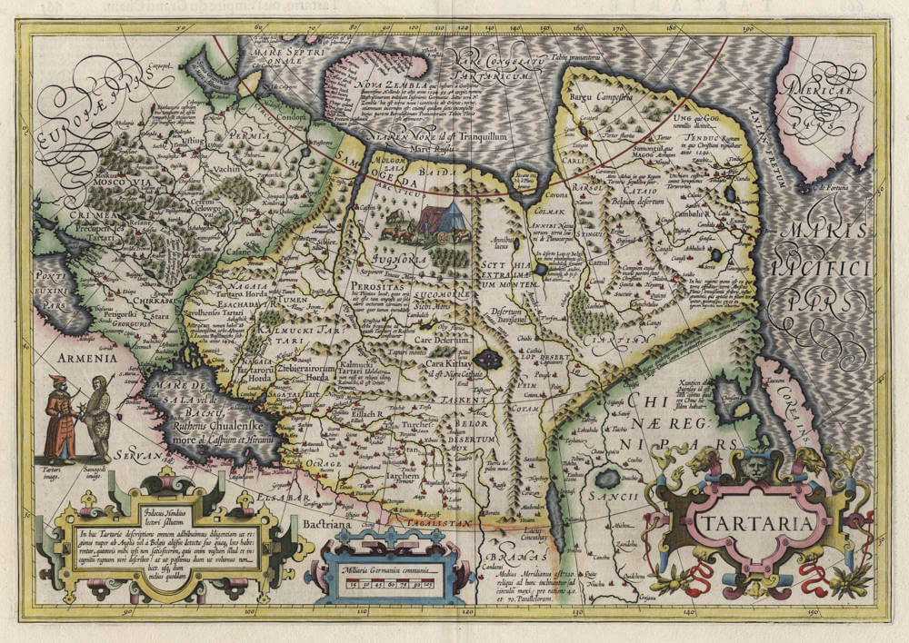
Title
Tartaria
First Published
Amsterdam, 1606
This Edition
1619 French edition
Size
34.3 x 49.4 cms
Technique
Condition
mint
Price
This Item is Sold
Description
Jodocus Hondius lovely map of Tartaria, first issued in the 1606 Mercator-Hondius series of atlases. Beautiful 'silk' engraving of the Oceans, typical of Jodocus Hondius. Highly appealing map of the region.
Condition
A pristine example in spectacular original hand color, applied at the time of production by colouring department of the publishing house. Wide margins, clean and thick paper, which is highly unusual for maps from this atlas. Paper with beautiful patina of the centuries. A crisp and even early imprint of the copperplate, from the 1619 edition for the French markets. No restorations or imperfections. One of the best examples ever seen. A magnificent collector's example of this legendary map of the area.
Cartouche text
Iodocus Hondius lectori salutem
In hac Tartariæ descriptione omnem adhibuimus diligentiam ut regiones nuper ab Anglis vel à Belgis alijsve detectæ suo quæq; loco habe;rentur, quanvis mihi ipfi non satisfecerim, quis enim vafum illud et incognitum regnum verè describet? at ut possumus dum ut volumus non licet. vlti; dum melius quoddam
Jodocus Hondius greets the reader
In this description of Tartaria, we have applied all diligence so that the regions recently discovered by the English or by the Dutch or others would be located in their proper places, although I myself am not satisfied; for who will truly describe that vast and unknown kingdom? But we do as we can, since we cannot do as we would like. We hope for something better.
Northeast Passage text
NOVA ZEMBLA quæ lustrari à Guilielmo Barentsono Hollando et alijs anno 1594.95.96 coeptis, nomine Illustrißimorum Ordinum Inferioris Germaniæ. Sine vero N. Zembla hoc est terra nova) continens ab Oriente, necne, etiamnum incertum est: etiamsi quidam satis inconſultè huius partem Borealißimam Promontorium Tabin Plinio esse affirment.
NOVA ZEMBLA which began to be explored by Willem Barentsz the Dutchman and others in the years 1594, 95, 96, on behalf of the Most Illustrious Orders of the Netherlands. Whether true North Zembla (that is, new land) is contiguous from the East, is still uncertain; although some quite rashly assert that the most northern part of it is the Promontory of Tabin mentioned by Pliny.
Chinese Wall text
Murus quadringentarum Leucarum inter montium crepidines a Rege China contra irruptiones Tartarorum exstructus.
A wall of four hundred leagues [leucas] built among the mountain ridges by the King of China against the incursions of the Tartars.
Jodocus Hondius (1563-1612)
Jodocus Hondius the Younger (son) (1594-1629)
Henricus Hondius (son) (1597-1651)
Jodocus Hondius the Elder, one of the most notable engravers of his time, is known for his work in association with many of the cartographers and publishers prominent at the end of the sixteenth and the beginning of the seventeenth century.
A native of Flanders, he grew up in Ghent, apprenticed as an instrument and globe maker and map engraver. In 1584, to escape the religious troubles sweeping the Low Countries at that time, he fled to London where he spent some years before finally settling in Amsterdam about 1593. In the London period he came into contact with the leading scientists and geographers of the day and engraved maps in The Mariner's Mirrour, the English edition of Waghenaer's Sea Atlas, as well as others with Pieter van den Keere, his brother-in-law. No doubt his temporary exile in London stood him in good stead, earning him an international reputation, for it could have been no accident that Speed chose Hondius to engrave the plates for the maps in The Theatre of the Empire of Great Britaine in the years between 1605 and 1610.
In 1604 Hondius bought the plates of Mercator's Atlas which, in spite of its excellence, had not competed successfully with the continuing demand for the Ortelius Theatrum Orbis Terrarum. To meet this competition Hondius added about 40 maps to Mercator's original number and from 1606 published enlarged editions in many languages, still under Mercator's name but with his own name as publisher. These atlases have become known as the Mercator/ Hondius series. The following year the maps were re-engraved in miniature form and issued as a pocket Atlas Minor.
After the death of Jodocus Hondius the Elder in 1612, work on the two atlases, folio and miniature, was carried on by his widow and sons, Jodocus II and Henricus, and eventually in conjunction with Jan Jansson in Amsterdam. In all, from 1606 onwards, nearly 50 editions with increasing numbers of maps with texts in the main European languages were printed.
(Moreland and Bannister)
Related Categories
Related Items


