Leen Helmink Antique Maps
Antique map of Borneo, Celebes, Bali, Lombok, Sumbawa by Thornton
The item below has been sold, but if you enter your email address we will notify you in case we have another example that is not yet listed or as soon as we receive another example.

Stock number: 19307
Zoom ImageCartographer(s)
Samuel Thornton (biography)
Title
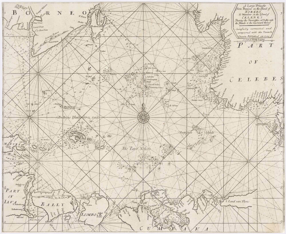
A Large Draught from Benjar on the Island of BORNEO, to Macasser on the Island of Celebes Shewing the Streights of Bally with the Islands to the Eastward thereof
First Published
London, 1711
This Edition
1745
Size
43.7 x 53.0 cms
Technique
Condition
excellent
Price
This Item is Sold
Description
Highly detailed cornerstone sea chart of the Java Sea, by Samuel Thornton, produced for the English East India Company.
From the rare sea atlas "The English Pilot, the third book. Describing the Oriental Navigation."
The navigation chart stretches from Borneo's northwest edge near Banjarmasin to Java and Bali in the southwest, southeast reaches "t Land van Floris", and up to Celebes in the northeast, including the important sea port of Macassar.
The intricate string of islands in the center is appropriate referred to as "The Pater Nosters".
The chart is based on the Dutch VOC's manuscript charts of the region, and is full of detailed navigational information, including depth soundings, safe anchorages, dangerous cliffs, rocks and sand banks, and coastal profiles.
First published in 1711, here in the second state of 1745 with a few depth soundings added.
Condition
Margins short as often but complete. No restorations or imperfections. Attractive example of a detailed and sought-after early navigation chart of the area.
Samuel Thornton (c.1665-1712)
Samuel Thornton: Navigating the East with Cartographic Precision
In the annals of 17th and early 18th century cartography, Samuel Thornton stands out not just as a prolific mapmaker, but as a vital link in a family tradition of maritime charting. Born in 1665 to John Thornton, a respected hydrographer and map publisher, Samuel inherited both his father's business acumen and passion for cartography.
Samuel Thornton became one of the most distinguished mapmakers of his era, particularly known for his contributions to the English East India Company (EIC) in the early 18th century. Living in a period when global exploration and maritime trade were expanding rapidly, Thornton's expertise and craft played a pivotal role in facilitating navigation, trade, and expansion for England.
The EIC, established in 1600, was one of the world's most powerful trading companies, and by the 18th century, it commanded vast territories in the East, including parts of the Indian subcontinent. The company's success relied heavily on the accuracy and detail of maritime charts and maps. This is where Samuel Thornton's skills shone. His dedication to precision, combined with an artistic flair, made his maps not only practical navigational tools but also works of art.
Many of Thornton's maps focused on the seas and coastlines of Asia. They often provided intricate details of the coasts, ports, and anchorages, invaluable information for the sea captains and merchants who were venturing into unfamiliar waters. At a time when the slightest navigational error could result in shipwrecks or lost cargo, Thornton's meticulous work undoubtedly saved many lives and fortunes.
While his primary focus was on Asian waters, Thornton's portfolio was not limited to this region. He also produced maps of other parts of the world, often collaborating with other cartographers and integrating the latest discoveries into his work. As a result, his maps were continuously updated, reflecting the evolving knowledge of the world during this Age of Exploration.
At a time when the British Empire was expanding its reach across the globe, Samuel Thornton's maps became essential tools for exploration, conquest, and commerce.
The English Pilot, for which Samuel is best remembered, is a series of sea atlases that aimed to provide comprehensive navigational guides for English mariners. First published by his father, John Thornton, the series was taken over and expanded upon by Samuel after John's death in 1708. These atlases, with their detailed charts and sailing directions, were indispensable to sailors, and they became the standard navigational texts for English mariners for several decades.
Samuel's dedication to detail and accuracy is evident. He went to great lengths to ensure that his charts were as precise and up-to-date as possible. In a time when global exploration was rapidly expanding, and the New World was still being charted, the importance of accurate and accessible maps cannot be overstated.
Beyond "The English Pilot," Samuel also produced a myriad of other maps, many of which focused on the coasts and waters of Asia, reflecting the growing importance of the East India trade. These maps, like those in "The English Pilot," were renowned for their accuracy and detail, making them invaluable tools for the merchants and captains of the English East India Company.
Today, original copies of Thornton's maps are highly prized by collectors and historians. They are a testament to the craft and science of map-making during one of the most dynamic periods in world history and stand as a tribute to a man whose work charted the course of empires.


