Leen Helmink Antique Maps
Antique map of South East Asia by Henricus Hondius

Stock number: 19825
Zoom ImageCartographer(s)
Henricus Hondius (biography)
Title
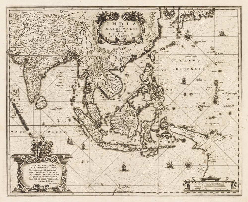
India quae Orientalis dicitur, et Insulae Adiacentes.
First Published
Amsterdam, 1638
Size
41 x 50 cms
Technique
Condition
mint
Price
$ 2,750.00
(Convert price to other currencies)
Description
One of the best and most famous 17th century maps of the region, from the Golden Age of Dutch cartography. Boldly engraved on a network of rhumb lines, richly embellished with title cartouches, scalebar, compass roses, and galleons.
A seminal map stretching from India to Japan, and one of the first printed maps to show parts of Australia as discovered by the Dutch between 1606 and 1623, before the expeditions of Abel Tasman. Strait Torres between New Guinea and Cape York is not known, although the possibility is left open. Korea is considered to be an island. Japan is very inaccurate, although three main islands are acknowledged. The map shows the first relatively accurate depiction of the complex archipelago of the Philippines.
A classic map of Southeast Asia and Australia which is also important in the history of the mapping of Australia. It includes the Indian subcontinent, part of Japan, the northern coastline of New Guinea, all of the East Indies, the Philippines and the Maldives and other island groups in addition to an early glimpse of Australia. Tooley, in his Printed Maps of Australia, notes that in this map 'Australia is represented by ... 'Landt van d'Endracht and part of the coast of Carpentria ... one of the earliest Dutch maps to show the beginning of the mapping of Australia.' (Tooley Australia 721).
Literature
van der Krogt New Koeman [8400:1B.1].
Significance
One of the best and most famous 17th century maps of the region, from the Golden Age of Dutch cartography.
Condition description
First edition, first state, in very fine collector's condition.
Jodocus Hondius (1563-1612)
Jodocus Hondius II (son) (1594-1629)
Henricus Hondius (son) (1597-1651)
Jodocus Hondius the Elder, one of the most notable engravers of his time, is known for his work in association with many of the cartographers and publishers prominent at the end of the sixteenth and the beginning of the seventeenth century.
A native of Flanders, he grew up in Ghent, apprenticed as an instrument and globe maker and map engraver. In 1584, to escape the religious troubles sweeping the Low Countries at that time, he fled to London where he spent some years before finally settling in Amsterdam about 1593. In the London period he came into contact with the leading scientists and geographers of the day and engraved maps in The Mariner's Mirrour, the English edition of Waghenaer's Sea Atlas, as well as others with Pieter van den Keere, his brother-in-law. No doubt his temporary exile in London stood him in good stead, earning him an international reputation, for it could have been no accident that Speed chose Hondius to engrave the plates for the maps in The Theatre of the Empire of Great Britaine in the years between 1605 and 1610.
In 1604 Hondius bought the plates of Mercator's Atlas which, in spite of its excellence, had not competed successfully with the continuing demand for the Ortelius Theatrum Orbis Terrarum. To meet this competition Hondius added about 40 maps to Mercator's original number and from 1606 published enlarged editions in many languages, still under Mercator's name but with his own name as publisher. These atlases have become known as the Mercator/ Hondius series. The following year the maps were re-engraved in miniature form and issued as a pocket Atlas Minor.
After the death of Jodocus Hondius the Elder in 1612, work on the two atlases, folio and miniature, was carried on by his widow and sons, Jodocus II and Henricus, and eventually in conjunction with Jan Jansson in Amsterdam. In all, from 1606 onwards, nearly 50 editions with increasing numbers of maps with texts in the main European languages were printed.
(Moreland and Bannister)
Related Categories
Related Items


