Leen Helmink Antique Maps
Antique map of Western Australia by Captain James Stirling

Stock number: 19111
Zoom ImageCartographer(s)
Captain James Stirling (biography)
Title
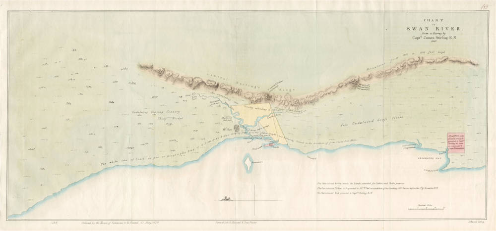
CHART OF SWAN RIVER from a survey by Capt'n James Stirling. R.N. 1827.
First Published
London, 1829
This Edition
1829 first and only edition
Size
62.8 x 27.6 cms
Technique
Condition
mint
Price
This Item is Coming Soon
Description
The first inland survey of Western Australia and the foundation map of the new colony. The map is rare because it was printed exclusively for members of parliament (House of Commons). Here complete with the accompanying Parliamentary papers on the proposed new colony.
Summary
This map of the Swan River and surrounds is the first published map of the proposed new settlement. Based directly on the survey work conducted by Stirling in 1827, it was presented to the British and Irish Parliament along with parliamentary papers in the hope that it would convince the Crown to establish a colony in Western Australia. The accompanying letter signed 4 November, 1828 by Thomas Peel, Francis Vincent, Edward Schenley and T. Potter Macqueen argued to the Crown the importance of establishing such a settlement. It was on the strength of this submission and Stirling's own reports and map that the Crown finally agreed to settle the Swan River.
(Simon Dewez}
STIRLING, Captain James 1829
CHART OF SWAN RIVER from a survey by Capt'n James Stirling. R.N. 1827.
Ordered by the House of Commons to be Printed,
13 May 1829 (bottom 1.h.s.).
James & Luke Ge. Hansard & Sons, Printers (bottom centre).
J.Basire lithog. (bottom r.h.s.)
'185' in ms (top r.h.s.).
62.8 x 27.6 cms
Fine original wash colour and mint condition. Attached to the complete set of Parliamentary papers. Foremost provenance.
Published in Great Britain and Ireland Parliamentary papers - first paper ‘Correspondence of the Colonial Department with certain Gentlemen proposing to form a settlement in the Neighbourhood of the Swan River, in Western Australia.’ House of Commons sessional papers 1829. ‘Ordered, by the House of Commons, to be Printed, 13 May 1829.’
The first published chart of the proposed colonial development at Swan River in Western Australia, based directly on the 1827 surveys by Captain James Stirling. Attached to original text documenting the submission to Parliament as well as various related letters of correspondence.
As the eastern part of Australia began to prosper, concern arose in the British Government and the Admiralty over the possibility that the French might consider taking possession of the unprotected west Australian coast. These rumours motivated Governor Darling to send Major Lockeyer to take possession of King George's Sound (Albany) in 1827. To that end Lockeyer did manage to establish a small colony, however the absence of suitably supportive hinterland made the site less than appealing to Darling. Meanwhile, Captain James Stirling was pursuing similar objectives further north at Swan River.
James Stirling was born 28 January 1791 in Drumpellier in Lancashire. He gained his first commission when 21 year old and fought against Napoleon. With the cessation of conflict with the French in 1815, many commissioned officers, including Stirling, were placed on half pay. It wasn't until eight years later that Stirling finally received a break. He was given command of the HMS Success and ordered to sail to Sydney, where he was to commence further exploration. Arriving in late 1826, Stirling's first assignment was to explore the possibility of establishing a settlement in northern Australia, however reports of the seriousness of the monsoons in the area at this time of the year, forced Stirling to delay the trip. Instead he sought permission to explore the Swan River in Western Australia with similar ideas of settlement in mind. Governor Darling immediately granted this request and so Stirling set out from Sydney in the Success in January 1827, arriving at Rottnest Island on 4 March 1827.
Four days later on 8 March 1827, Stirling and eighteen men set off in two small boats to explore the river that the Dutchman Willem de Vlamingh had named 'Swaenerivier' after sighting the extraordinary black swans there in 1697. Stirling and his crew proceeded upstream as far as they could by boat, then continued by land to the nearby ranges. Stirling named these ‘General Darling's Range’ in honour of the Governor.
In stark contrast to Lockeyer's report, Stirling gave a glowing description of the area. So appealing was his report that Darling sent Stirling back to England so that he could personally present his case for a Swan River settlement, directly to the Governor. The Crown finally conceded to form a settlement at the Swan River site. To that end Captain Fremantle in the HMS Challanger was sent to Western Australia (or “New Holland', as it was known at the time) to formally take possession for Britain, that part of the country. This he accomplished on arrival at Swan River on 2 May 1829.
Four weeks later on 31 May, Stirling, his wife Ellen and their three-year old son Andrew arrived at Swan River on the Quebec built transport Parmelia, accompanied by a group of free settlers. In his capacity as Lieutenant Governor, Stirling chose Fremantle at the mouth of the Swan River as the site for the settlement’s port, while selecting a picturesque spot some twenty miles upstream near Mount Eliza as the new capital. Perth, which was named by Stirling after a Scottish town, was officially founded during a simple ceremony conducted on 12 August that year, when Mrs Helen Dance symbolically felled a small tree.
This map of the Swan River and surrounds is the first published map of the proposed new settlement. Based directly on the survey work by Stirling in 1827, it was presented to the British and Irish Parliament along with parliamentary papers, in the hope that it would convince the Crown to establish a colony in Western Australia. The accompanying letter signed 4 November 1828 by Thomas Peel, Francis Vincent, Edward Schenley and T. Potter Macqueen, argued to the Crown the importance of establishing such a settlement. It was on the strength of this submission and Stirling's own reports and map that the Crown finally agreed to settle Swan River.
Stirling's map covers a 500 kilometre stretch of the Western Australian coast from Cape Leeuwin and Augusta in the south to around Jurien and Green Head in the north. The Darling Ranges and Rottnest Island are also shown. The map is annotated with comments detailing the suitability of the surrounding hinterland for agriculture as well as the availability of fresh water, both essential elements for the consideration of the establishment of a new colony. A further note recognising the importance that Stirling played in the exploration of the region states ‘About 90,000 acres of Land are to be granted to Cap 'n Stirling as near as convenient to Cape Naturaliste.
Stirling went on to become the first Governor of Western Australia, an appointment he was granted in November 1831.
Ferguson 1265; Perry / Prescott 1829.02: Not in Tooley: See 19 May edition Tooley 1209; NLA AMICUS 23323252.
(Simon Dewez' description of this very same copy of the map)
Captain James Stirling (1791-1865)
Captain (later Sir) James Stirling was the first Governor of the Colony of Western Australia, from 30 December 1828 until 2 January 1839.
He was born on 28 January 1791 in Lanarkshire, Scotland. In 1826 he commanded HMS Success to report on the Swan River. In June 1829 he formed a British settlement in Western Australia.
Shortly after, Stirling led a group of officials, soldiers and sailors up the Swan Estuary landing near the site of the present Stirling Gardens, adjacent to what is now the Government House Domain. The party cleared the land and erected tents on a patch of higher ground and from this campsite the city of Perth evolved.
Stirling was married to Ellen Mangles and they had eleven children; five sons and six daughters.
(Government House Western Australia)


