Leen Helmink Antique Maps
Antique map of the World by Fries / Waldseemüller
The item below has been sold, but if you enter your email address we will notify you in case we have another example that is not yet listed or as soon as we receive another example.

Stock number: 19105
Zoom ImageDescription
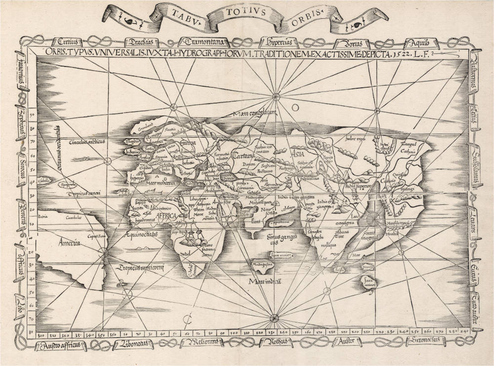
From the 1535 Lyon edition, published by Michael Servetus. This is the only edition of the map that has a decorative title scroll above the map.
Condition
Strong and even imprint of the woodblock. Excellent collector's condition.
Cornerstone world map from the early days of Portuguese exploration. The map (classified as a sea chart in the title) reflects the great confusion and ambiguities of the time, combining the classical antiquity view of the world with the newly discovered lands. The map is the first obtainable map to name "America", and the first obtainable map that abandons the classical concept of a large South Land (Terra Australis).
This is the second state of Fries' map of the New World with a second title in a dramatic banner above the map.
Unlike Fries' other world map, this version of the Fries new world map, although influenced by the 1513 Waldseemuller map, is clearly Fries' own work. Both maps are according to Shirley “the earliest world maps that collectors can still obtain...”. Fries' map is of particular interest as it portrays to some extent, the current indecision about the nature of the world at that time. America had only been discovered some thirty years earlier and images of this New World had just started to make their way onto maps. The world is shown largely in Ptolemaic format with the new addition of America somewhat squeezed into place. America is crudely represented, as is the Malay Peninsula, which is elongated and curved. Only ‘Java Minor' and two other islands are shown in Southeast Asia. Java (*Java Maior') and Madagascar are placed next to each other in the middle of the Indian Ocean. There is no mention of Terra Australis Incognita. England and Scotland are shown as separate islands. Wind names are labelled in the banners that border the map and are linked by rope.
Shirley mentions that at some stage a title banner was added to the map, as in this case, causing a crack in the block running from the right hand middle side to almost across the whole plate. It seems however that the crack occurred independently of the banner. The map illustrated in Shirley's own book shows sign of the crack but lacks the title banner. Similarly, Sotheby's 11th March 1999 'Important Atlases’ sale, lot 62, illustrates a 1525 Strassburg edition without title banner but with the significant crack. Certainly comparison with Fries' second New World map illustrated in Manasek's book and also having a banner above the map, would suggest that the banner came to be used in 1535 - as stated by Manasek. It would also appear that the banners on both of Fries' New World maps are identical and from a separate block, and not added to the plate.
(Simon Dewez)
"A famous [woodcut] world map by Frisius derived from Waldseemüller's wall map of 1516. Probably the earliest map mentioning the name America which is available to collectors [the rare Apian 1520 being the first]."
(Moreland & Bannister).
"the first map from a Ptolemaic atlas to use the word America."
(Potter).
"The [Ptolemy] edition contains a general map by Laurentius Frisius and two new maps of eastern Asia.
Out of the three maps, not borrowed from the [Ptolemy] edition of 1513, the map of the world by Laurentius Frisius is certainly an original work. The other two maps are the Tabulae Moderna Indiae orientalis and Tabula superioris Indiae et Tartariae Majoris. A closer examination of these maps shows that they are still almost exclusively based on traditions from Marco Polo, and the globe of Behaim. They may indeed, to a certain extent, be considered as the first reproduction of this globe, so often referred to in modern geographical literature."
(Nordenskiöld).
"Fries' map is much sought after as it somehow reflects the ambiguities of his age. A framework of medieval thinking is having to be re-cast in order to accept the as yet unrealised extent of the newly conquered lands. For decorative value, if not for accuracy, the map has considerable attractions. It is one of the earliest world maps that collectors can still obtain through map sellers, albeit at an increasingly high price."
(Shirley).
"Laurent Fries's rather crudely drawn map of the world is framed by linked panels containing the names of the winds. South America is shown, albeit too close to Africa, and it is given a western coastline. This was inserted more by intuition than by report, for Magellan's ship did not return to its home port in Spain until after the atlas was published. Spagnola [Hispanola] and Isabella [Cuba] are again correctly marked.
England and Scotland are separated by a stretch of water (an early error previously eliminated) and Madagascar is sited in the middle of the Indian Ocean. The Malay peninsula almost touches Ceylon, but the separate existence of Java is carefully recorded. China, under the name Cathaia, is marked but Japan, although mentioned by Marco Polo in his account of his travels, 'Il Millione', written in 1296-98, does not appear."
(Allen).
Laurent Fries (c.1490-c.1532)
Laurent Fries (Laurentius Frisius), born in Mulhouse in Burgundy, travelled widely, studying as a physician and mathematician in Vienne, Padua, Montpellier and Colmar before settling in Strassburg. There he is first heard of working as a draughtsman on Peter Apian's highly decorative cordiform World Map, published in 1520. Apian’s map was based on Waldseemüller's map of 1507 which no doubt inspired Fries's interest in the Waldseemüller Ptolemy atlases of 1513 and 1520 and brought him into contact with the publisher, Johannes Grüninger. It is thought that Grüninger had acquired the woodcuts of the 1520 edition with the intention of producing a new version to be edited by Fries. Under his direction the maps were redrawn and although many of them were unchanged, except for size, others were embellished with historical notes and figures, legends and the occasional sea monster. Three new maps were added.
There were four editions of Fries' reduced sized re-issue of Waldseemüller's Ptolemy atlas:
1522 Strassburg: 50 woodcut maps, reduced in size, revised by Laurent Fries (Laurentius Frisius) and included the earliest map showing the name ‘America' which is likely to be available to collectors
1525 Strassburg: re-issue of 1522 maps
1535 Lyon: re-issue of 1522 maps, edited by Michael Servetus who was subsequently tried for heresy and burned at the stake in 1553, ostensibly because of derogatory comments in the atlas about the Holy Land – the fact that the notes in question had not even been written by Servetus, but were copied from earlier editions, left his Calvinist persecutors unmoved
1541 Vienne (Dauphiné): re-issue of the Lyon edition - the offensive comments about the Holy Land have been deleted
(Moreland and Bannister)
Martin Waldseemüller (c.1470-1518)
Waldseemüller, born in Radolfzell, a village on what is now the Swiss shore of Lake Constance, studied for the church at Freiburg and eventually settled in St Dié at the Court of the Duke of Lorraine, at that time a noted patron of the arts. There, in the company of likeminded savants, he devoted himself to a study of cartography and cosmography, the outcome of which was a world map on 12 sheets, now famous as the map on which the name “America’ appears for the first time. Suggested by Waldseemüller in honour of Amerigo Vespucci (latinised: Americus Vesputius) whom he regarded, quite inexplicably, as the discoverer of the New World, the new name became generally accepted by geographers before the error could be rectified, and its use was endorsed by Mercator on his world map printed in 1538. Although only one copy is now known of Waldseemüller's map and of the later Carta Marina (1516) they were extensively copied in various forms by other cartographers of the day.
Waldseemüller is best known for his preparation from about 1507 onwards of the maps for an issue of Ptolemy's Geographia, now regarded as the most important edition of that work. Published by other hands in Strassburg in 1513, it included 20 ‘modern' maps and passed through one other edition in 1520. Four more editions on reduced size were issued of the Laurent Fries version.
It remained the most authoritative work of its time until the issue of Münster's Geographia in 1540 and Cosmographia in 1544.
(Moreland and Bannister)
Related Categories
Related Items


