Leen Helmink Antique Maps
Antique map of the World by Fries / Waldseemüller / Ptolemy
The item below has been sold, but if you enter your email address we will notify you in case we have another example that is not yet listed or as soon as we receive another example.

Stock number: 19052
Zoom ImageDescription
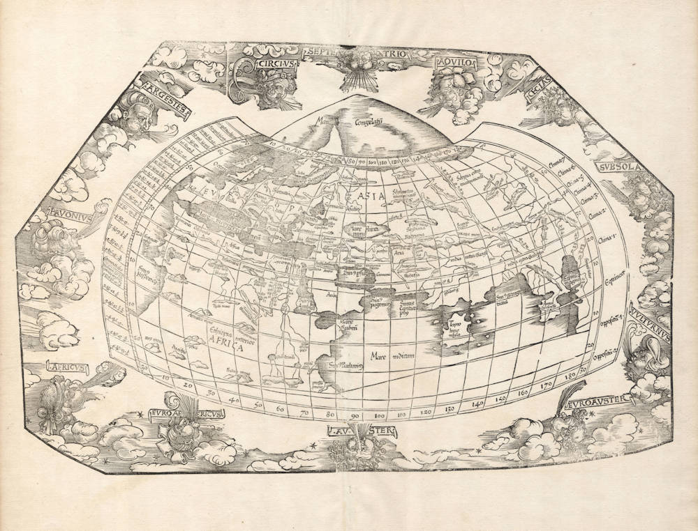
Fries' map is a reduced copy of Waldseemüller's 1513 Ptolemy map of the world. Somewhat surprisingly, and unrecorded in the literature, Waldseemüller had erroneously reversed the eastern and western winds from classical antiquity. Fries took over that mistake in his first 1522 edition of the map, but corrected it when adding the decorated border with the heads of the winds in the 1525 edition. It is also noteworthy that where Waldseemüller uses Ptolemy's canonical projection, which is relatively simple to draw, Fries has chosen Ptolemy's second "cloak" (chlamys) projection, which provides a far more satisfactory image of the earth's shape, but is also much harder to contruct, because both the lines of latitude as well as the lines of longitude are curved.
This example from the early 1525 Strassburg edition. In this edition the map has no title, therefore the title we use is the one used in the first 1522 edition. The woodcut decorations around the map are attributed to Albrecht Dürer, who also made the famous woodcut print of the armillary sphere in this atlas.
Condition
Strong and early imprint of the woodblock. Mint collector's condition.
The Mapping of the World
"Waldseemüller's Ptolemaic map of 1513 has been redrawn and reduced in size in this publication by Laurent Fries, geographer and physician, The printer was Johann Grüninger.
The [1535] Lyons edition was printed by Melchior and Gaspar Treschel; it was ordered to be burnt by Calvin because of alleged heresy and is therefore rare."
(Shirley).
Fries' version of Waldseemüller's Ptolemy's map of the world, which had been amended with a crude Scandinavian peninsula outside the traditional Ptolemy map.
"Laurent Fries' reduced copy of Waldseemüllers' 1513 Ptolemy world map. Slight emendations have been applied to Ptolemy: the land which to the south of the Indian ocean unites Africa and Asia is left out."
(Nordenskiöld).
"Since many copies (of the book) were burnt by order of Calvin, it has become rare."
(Mortimer).
Waldseemüller's 1513 Ptolemy map of the World
Waldseemüller's 1513 Strassburg Ptolemy is the most important edition of the Geographia on account of the many new regional maps it contains. Preparatory work was begun in about 1505 by Martin Waldseemüller, scholar-geographer of the small town of St. Dié in Lorraine, together which his associate Mathias Ringmann. Waldseemüller is believed to have incised many of the maps himself; all are firm distinctive woodcuts. By 1507 much progress had been made but - possibly because of his large world map commitments - the project was delayed and was not completed until 1513 under the editorship of Jacob Eszler and Georg Ubelin. The printer was Johann Schott, and the work, the first modern atlas, bears a dedication to the Emperor Maximilian. There are two noteworthy world maps: a Ptolemaic one and a modern one showing the latest discoveries.
The Ptolemaic world map is a bold woodcut on the traditional modified conical projection with all regions above 65° north (just north of the British Isles) covered by the inscription Mare Congelatum or 'Frozen Sea'. The continents represented follow the Ptolemaic outline although the wood cutter has not felt he could sustain the concept of a land-locked Indian Ocean and so has omitted the strip of land normally linking southern Africa to Asia. The map itself is bordered by the usual markings of latitude and longitude and the climates. Outside this is a vigorous surround of clouds with twelve characteristic windheads representing the classical winds blowing from each direction. Visually, it is one of the most attractive Ptolemaic world maps produced.
(Rodney Shirley, The Mapping of the World Map 34).
Laurent Fries (c.1490-c.1532)
Laurent Fries (Laurentius Frisius), born in Mulhouse in Burgundy, travelled widely, studying as a physician and mathematician in Vienne, Padua, Montpellier and Colmar before settling in Strassburg. There he is first heard of working as a draughtsman on Peter Apian's highly decorative cordiform World Map, published in 1520. Apian’s map was based on Waldseemüller's map of 1507 which no doubt inspired Fries's interest in the Waldseemüller Ptolemy atlases of 1513 and 1520 and brought him into contact with the publisher, Johannes Grüninger. It is thought that Grüninger had acquired the woodcuts of the 1520 edition with the intention of producing a new version to be edited by Fries. Under his direction the maps were redrawn and although many of them were unchanged, except for size, others were embellished with historical notes and figures, legends and the occasional sea monster. Three new maps were added.
There were four editions of Fries' reduced sized re-issue of Waldseemüller's Ptolemy atlas:
1522 Strassburg: 50 woodcut maps, reduced in size, revised by Laurent Fries (Laurentius Frisius) and included the earliest map showing the name ‘America' which is likely to be available to collectors
1525 Strassburg: re-issue of 1522 maps
1535 Lyon: re-issue of 1522 maps, edited by Michael Servetus who was subsequently tried for heresy and burned at the stake in 1553, ostensibly because of derogatory comments in the atlas about the Holy Land – the fact that the notes in question had not even been written by Servetus, but were copied from earlier editions, left his Calvinist persecutors unmoved
1541 Vienne (Dauphiné): re-issue of the Lyon edition - the offensive comments about the Holy Land have been deleted
(Moreland and Bannister)
Martin Waldseemüller (c.1470-1518)
Waldseemüller, born in Radolfzell, a village on what is now the Swiss shore of Lake Constance, studied for the church at Freiburg and eventually settled in St Dié at the Court of the Duke of Lorraine, at that time a noted patron of the arts. There, in the company of likeminded savants, he devoted himself to a study of cartography and cosmography, the outcome of which was a world map on 12 sheets, now famous as the map on which the name “America’ appears for the first time. Suggested by Waldseemüller in honour of Amerigo Vespucci (latinised: Americus Vesputius) whom he regarded, quite inexplicably, as the discoverer of the New World, the new name became generally accepted by geographers before the error could be rectified, and its use was endorsed by Mercator on his world map printed in 1538. Although only one copy is now known of Waldseemüller's map and of the later Carta Marina (1516) they were extensively copied in various forms by other cartographers of the day.
Waldseemüller is best known for his preparation from about 1507 onwards of the maps for an issue of Ptolemy's Geographia, now regarded as the most important edition of that work. Published by other hands in Strassburg in 1513, it included 20 ‘modern' maps and passed through one other edition in 1520. Four more editions on reduced size were issued of the Laurent Fries version.
It remained the most authoritative work of its time until the issue of Münster's Geographia in 1540 and Cosmographia in 1544.
(Moreland and Bannister)
Claudius Ptolemy (c.100 - c.170)
Ptolemy, Latin in full Claudius Ptolemaeus was an Egyptian astronomer, mathematician, and geographer of Greek descent who flourished in Alexandria during the 2nd century AD. In several fields his writings represent the culminating achievement of Greco-Roman science, particularly his geocentric (Earth-centred) model of the universe now known as the Ptolemaic system.
Virtually nothing is known about Ptolemy’s life except what can be inferred from his writings. His first major astronomical work, the Almagest, was completed about 150 ce and contains reports of astronomical observations that Ptolemy had made over the preceding quarter of a century. The size and content of his subsequent literary production suggests that he lived until about 170 AD.
Astronomer
The book that is now known as the Almagest (from a hybrid of Arabic and Greek, “the greatest”) was called by Ptolemy Hē mathēmatikē syntaxis (“The Mathematical Collection”) because he believed that its subject, the motions of the heavenly bodies, could be explained in mathematical terms.
Mathematician
Ptolemy has a prominent place in the history of mathematics primarily because of the mathematical methods he applied to astronomical problems. His contributions to trigonometry are especially important. For instance, Ptolemy’s table of the lengths of chords in a circle is the earliest surviving table of a trigonometric function. He also applied fundamental theorems in spherical trigonometry (apparently discovered half a century earlier by Menelaus of Alexandria) to the solution of many basic astronomical problems.
Among Ptolemy’s earliest treatises, the Harmonics investigated musical theory while steering a middle course between an extreme empiricism and the mystical arithmetical speculations associated with Pythagoreanism. Ptolemy’s discussion of the roles of reason and the senses in acquiring scientific knowledge have bearing beyond music theory.
Geographer
Ptolemy’s fame as a geographer is hardly less than his fame as an astronomer. Geōgraphikē hyphēgēsis (Guide to Geography) provided all the information and techniques required to draw maps of the portion of the world known by Ptolemy’s contemporaries. By his own admission, Ptolemy did not attempt to collect and sift all the geographical data on which his maps were based. Instead, he based them on the maps and writings of Marinus of Tyre (c. 100 ce), only selectively introducing more current information, chiefly concerning the Asian and African coasts of the Indian Ocean. Nothing would be known about Marinus if Ptolemy had not preserved the substance of his cartographical work.
Ptolemy’s most important geographical innovation was to record longitudes and latitudes in degrees for roughly 8,000 locations on his world map, making it possible to make an exact duplicate of his map. Hence, we possess a clear and detailed image of the inhabited world as it was known to a resident of the Roman Empire at its height—a world that extended from the Shetland Islands in the north to the sources of the Nile in the south, from the Canary Islands in the west to China and Southeast Asia in the east. Ptolemy’s map is seriously distorted in size and orientation compared with modern maps, a reflection of the incomplete and inaccurate descriptions of road systems and trade routes at his disposal.
Ptolemy also devised two ways of drawing a grid of lines on a flat map to represent the circles of latitude and longitude on the globe. His grid gives a visual impression of Earth’s spherical surface and also, to a limited extent, preserves the proportionality of distances. The more sophisticated of these map projections, using circular arcs to represent both parallels and meridians, anticipated later area-preserving projections. Ptolemy’s geographical work was almost unknown in Europe until about 1300, when Byzantine scholars began producing many manuscript copies, several of them illustrated with expert reconstructions of Ptolemy’s maps. The Italian Jacopo d’Angelo translated the work into Latin in 1406. The numerous Latin manuscripts and early print editions of Ptolemy’s Guide to Geography, most of them accompanied by maps, attest to the profound impression this work made upon its rediscovery by Renaissance humanists.
(Britannica)
Related Categories
Related Items


 by Ruscelli")


