Leen Helmink Antique Maps
Antique map of Asia and the Indian Ocean by Fries / Waldseemüller

Stock number: 19030
Zoom ImageTitle
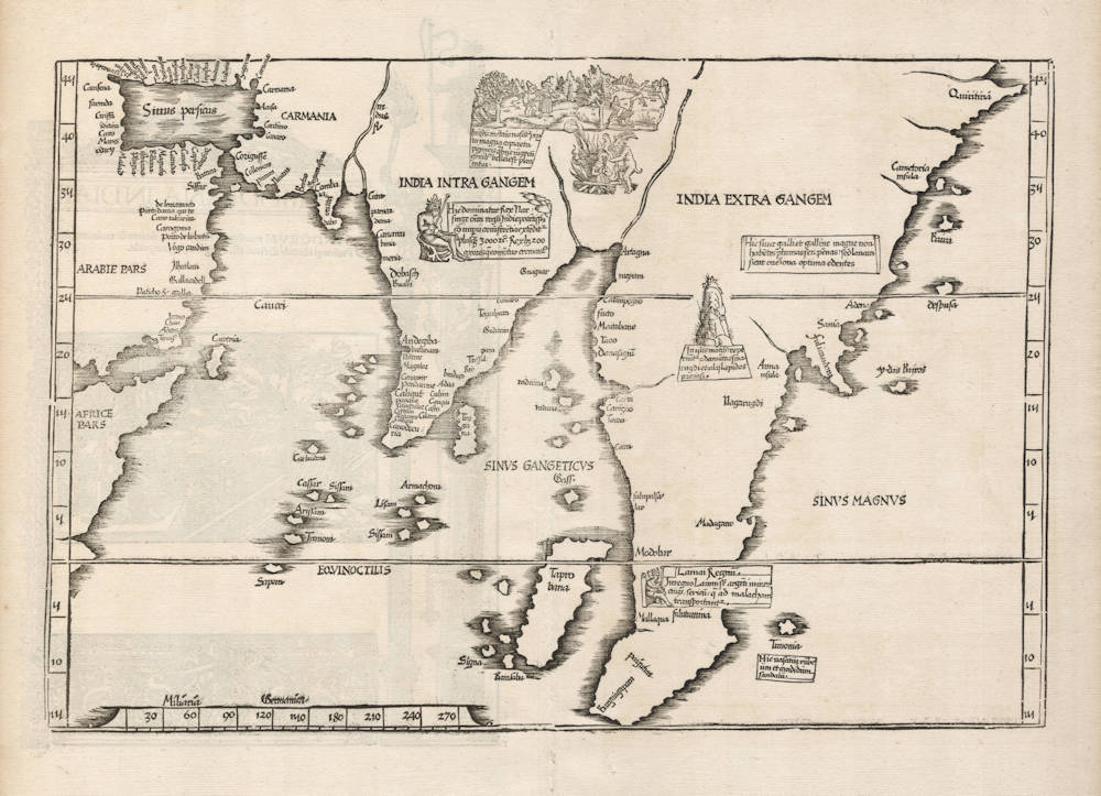
Indiae Tabula Moderna
First Published
Strassburg, 1522
This Edition
1525 second edition
Size
29.4 x 44.0 cms
Technique
Condition
pristine
Price
$ 4,250.00
(Convert price to other currencies)
Description
Laurentz Fries' 1522 version of Martin Waldseemüllers' 1513 map of the Indian Ocean. For the text legends on the map, Fries makes use of the text legends from Waldseemüllers' 1516 wall map of the world.
This example from the early 1525 Strassburg edition. The woodcut decorations on the back are attributed to Albrecht Dürer, who also made the famous woodcut print of the armillary sphere in this atlas.
"[The map is] evidently based on surveys undertaken during the two first voyages of Vasco da Gama"
(Nordenskiöld).
"The illustrations added by Fries contain material of ethnographic interest.
The picture of the woman on the funeral pyre is a reference to the custom of suttee which was widespread in the Indian cultural sphere. According to the inscription on the map, King Narsunga, the most powerful ruler in India, had 200 wives, all of whom were burned alive after his death.
The pygmies who live in the Himalayas, and who, according to legend, are constantly at war with the cranes, are illustrated too.
There is also a reference, of course, to the existence of diamonds, emeralds and other precious stones."
(Skelton).
The text legends on the map
For detailed transcriptions and translations of the Latin text legends on this map, as well as the sources for them, please contact us.
Condition
Here from the very rare 1525 Strassburg edition. A strong and even imprint of the woodblock. Thick and clean paper, with no restorations or imperfections. A pristine collector's example.
Laurent Fries (c.1490-c.1532)
Laurent Fries (Laurentius Frisius), born in Mulhouse in Burgundy, travelled widely, studying as a physician and mathematician in Vienne, Padua, Montpellier and Colmar before settling in Strassburg. There he is first heard of working as a draughtsman on Peter Apian's highly decorative cordiform World Map, published in 1520. Apian’s map was based on Waldseemüller's map of 1507 which no doubt inspired Fries's interest in the Waldseemüller Ptolemy atlases of 1513 and 1520 and brought him into contact with the publisher, Johannes Grüninger. It is thought that Grüninger had acquired the woodcuts of the 1520 edition with the intention of producing a new version to be edited by Fries. Under his direction the maps were redrawn and although many of them were unchanged, except for size, others were embellished with historical notes and figures, legends and the occasional sea monster. Three new maps were added.
There were four editions of Fries' reduced sized re-issue of Waldseemüller's Ptolemy atlas:
1522 Strassburg: 50 woodcut maps, reduced in size, revised by Laurent Fries (Laurentius Frisius) and included the earliest map showing the name ‘America' which is likely to be available to collectors
1525 Strassburg: re-issue of 1522 maps
1535 Lyon: re-issue of 1522 maps, edited by Michael Servetus who was subsequently tried for heresy and burned at the stake in 1553, ostensibly because of derogatory comments in the atlas about the Holy Land – the fact that the notes in question had not even been written by Servetus, but were copied from earlier editions, left his Calvinist persecutors unmoved
1541 Vienne (Dauphiné): re-issue of the Lyon edition - the offensive comments about the Holy Land have been deleted
(Moreland and Bannister)
Martin Waldseemüller (c.1470-1518)
Waldseemüller, born in Radolfzell, a village on what is now the Swiss shore of Lake Constance, studied for the church at Freiburg and eventually settled in St Dié at the Court of the Duke of Lorraine, at that time a noted patron of the arts. There, in the company of likeminded savants, he devoted himself to a study of cartography and cosmography, the outcome of which was a world map on 12 sheets, now famous as the map on which the name “America’ appears for the first time. Suggested by Waldseemüller in honour of Amerigo Vespucci (latinised: Americus Vesputius) whom he regarded, quite inexplicably, as the discoverer of the New World, the new name became generally accepted by geographers before the error could be rectified, and its use was endorsed by Mercator on his world map printed in 1538. Although only one copy is now known of Waldseemüller's map and of the later Carta Marina (1516) they were extensively copied in various forms by other cartographers of the day.
Waldseemüller is best known for his preparation from about 1507 onwards of the maps for an issue of Ptolemy's Geographia, now regarded as the most important edition of that work. Published by other hands in Strassburg in 1513, it included 20 ‘modern' maps and passed through one other edition in 1520. Four more editions on reduced size were issued of the Laurent Fries version.
It remained the most authoritative work of its time until the issue of Münster's Geographia in 1540 and Cosmographia in 1544.
(Moreland and Bannister)


