Leen Helmink Antique Maps
Antique map of India by Thevenot

Stock number: 18808
Zoom ImageCartographer(s)
Melchisedech Thévenot (biography)
Title
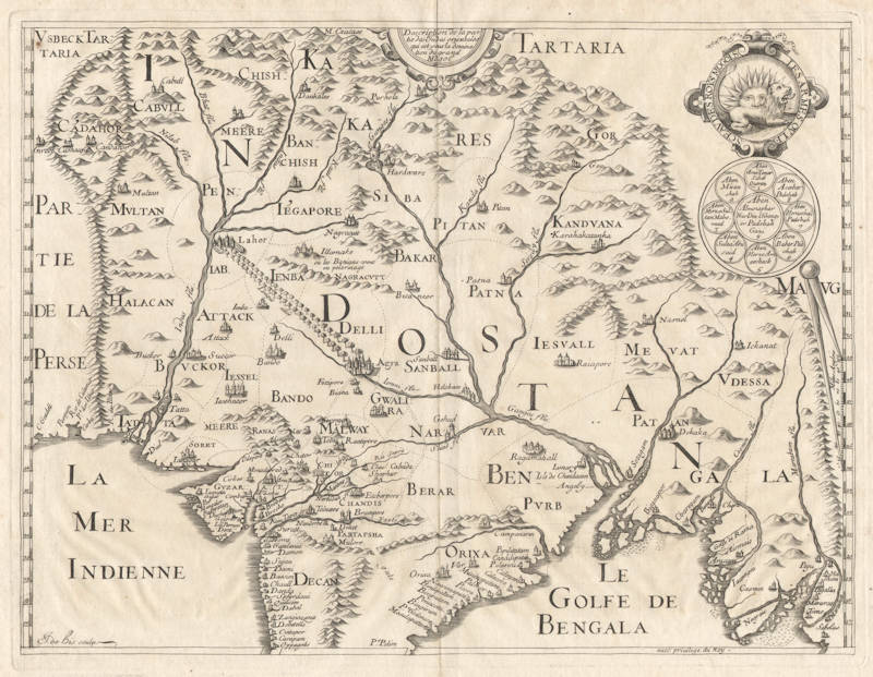
Description de la partie des Indes orientales qui est sous la domination du grand Mogol
First Published
Paris, 1663
This Edition
1663 first edition
Size
27 x 34.5 cms
Technique
Condition
mint
Price
$ 550.00
(Convert price to other currencies)
Description
Thevenot's rare version of William Baffin's 1619 map of the great Mogul Empire, the first accurate map of the area. Centered on the road between Lahor and Agra/Delhi, home of the newly finished Taj Mahal.
Melchisedech Thévenot (1620-1692)
A traveller and author of books on the early voyages of discovery, Thévenot produced some striking charts, perhaps not always his own work but no less interesting because of that. In particular, his map of Australia is the first by a Frenchman, showing the continent with the latest information on Tasman's voyages.
(Moreland and Bannister)
[Tasman] Thévenot, Melchisedech. Relations de Divers Voyages Cvrievx, qui n'ont point esté pvbliées; ov qvi et esté tradvites d'Haclvyt, de Purchas, & d'autres Voyageurs Anglois, Hollandais, Portugais, Allemands, Espagnols; et de quelques Persans, Arabes, et avtres Auteurs Orientaux. Enrichies de Figures de Plantes non décrites, d'Animaux inconnus à l'Europe, & de Cartes Geographiques de Pays dont on n'a point encore donné de Cartes. Première Partie. Paris, Jacques Langlois and Gaspard Meturas, Simon Piget, Emanuel Langlois, Thomas Jolly, and Louys Billaine, 1663.
Thévenot's great collection of voyages was published over three decades from 1663 - 1696. A scholar of prodigious energy, Melchisedech Thévenot assembled his remarkable collection of accounts of the newly explored and newly discovered regions of the world from original manuscript and printed texts, conversations with travellers, and other diverse sources, including accounts of travels in China, Japan, Thailand, Tartary, Mongolia, the Philippines, India, Egypt, Ethiopia, Arabia, Persia, Russia, North, Central and South America, the Pacific, New Guinea, and New Holland. His work grew, with various sections published haphazardly and then cumulated in 1663, 1666, 1672, 1683, and 1696.
Thévenot's Relations is a bibliographically complex work. Effectively there was only one edition, issued in parts over three decades. The first part (the present lot) was published in 1663. Between 1664 and 1683 Thévenot issued further parts and cumulative volumes of the parts already issued. In each case, these subsequent issues included some reprinted sheets, plates, and maps. In its final, posthumous, form the work was issued in 1696 in two volumes. The haphazard nature of publication - with the variously paged parts issued and re-issued, printed and reprinted - means that copies are never entirely identical and often 'incomplete'. Bibliographers have generally avoided detailed descriptions; as Brunet remarks, it is a book of which wil est difficile de trouver des exemplaires complets parce que chaque partie est composé de pièces séparées"; while Sabin declines to collate this or the 1696 edition since "no simple standard arrangement or collation can be given". Brunet notes several variations from copy to copy and the present example accords with his 'ideal description. Of the specific variations he records, the following have been noted in this copy: pp. 7-8 in Terri's voyage are replaced with the map of the Indies as noted "quelquefois” by Brunet; pp. 55-6 in the “Voyage de Bontekoë" are correctly numbered; and, finally, this copy includes at the end the “Routier des Indes Orientales" and the "Privilege” that are not always present.
(Australian Book Auctions, the Davidson Collection Sale, 2005)


