Leen Helmink Antique Maps
Antique map of the Southern Hemisphere by Wytfliet


Stock number: 19000
Zoom ImageCartographer(s)
Cornelis Wytfliet (biography)
Title
Chica sive Patagonica et Australis Terra
First Published
Louvain, 1597
This Edition
1597 1st edition 1st state
Size
23.0 x 29.4 cms
Technique
Condition
excellent
Price
This Item is Sold
Description
Rare first edition first state, with the publication date of 1597 in the title cartouche. Subsequent editions have the second state of the map, with the date erased from the copperplate.
Condition
A strong and even early impression of the copperplate. No paper restorations or imperfections. A excellent collector's example of a seminal map.
Summary
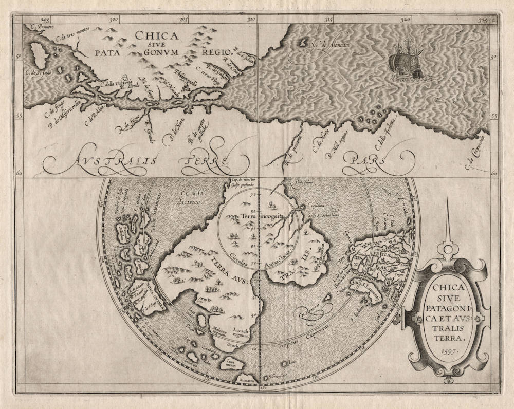
Wytfliet's fascinating copperplate of 1597 has two maps on one sheet: The primary overview map is Australis Terra, showing the entire Southern hemisphere on a polar projection, thus offering an unobstructed and detailed view of the unknown Southland. The upper section of the plate shows the "known" part of the Southland around Magellan's Strait on a separate map on much larger scale and in plane degrees projection, Chica sive Patagonia. This 1597 Cornelis Wytfliet double map was closely copied by Jean Metellus in 1598, and by Matthias Quad in 1600. The Wytfliet is the most important of the three, being the progenitor (original source) of the other two.
Terra Australis
The lower part consists of an early and important map of the Southern Hemisphere, covering today's Australia, Indonesia, South Africa, Patagonia and Antarctica. The map depicts nearly all of the southern hemisphere with the equator as boundary, it also shows the Circle of the Tropic of Capricorn and the Arctic Circle.
A big southern landmass (Terra Australis) is prominently depicted with quite some details including rivers, kingdoms, mountains and rivers. The map also gives a good view of the southern hemispherical parts of Africa, of the Indian Ocean, of the Indonesian Archipelago, of the southern Pacific and of the recently discovered Solomon Islands, which were initially believed to be part of Terra Australis, but turned out not to be.
This is the first map to focus on the mysterious and undiscovered Southland or Terra Australis. This polar projection is found on some 16th century world maps, notably the 1593 double hemisphere map on polar projection by Cornelis de Jode, which is loosely used as one of the sources for this map.
On the usual (flat and mercator) map projections, the southland is very distorted and incomplete because of the high southern latitudes, whereas the polar projection used here allows a clear unobstructed view of the fifth continent.
The theory of a large southern landmass was proposed by geographers in classical antiquity. The ancient Greeks scientists knew that the earth was a globe, and most (but not all) geographers were of opinion that the landmass they knew of in the northern hemisphere (formed by Europe, Asia, Northern Africa) would have to be counterbalanced by a landmass on the southern hemisphere, for the simple reasons of symmetry and equilibrium. The inhabitants of that landmass were referred to as antipodes, because they are upside down and their feet are opposite to those of the Greeks. The term Antarctic, as opposed to Arctic, was proposed as early as the 2nd century AD by Marinus of Tyre.
Some of the Greek books on geography survived the Dark Ages, particularly through the libraries in Constantinopel (Byzantium), who were preserving the cultural and scientific legacy of the Roman Empire. The rediscovery of the classical sources was of seminal value to the European Renaissance, including cartography and exploration.
The existence of a Southland was also confirmed by the Medieval book of Marco Polo, who reports from his sources in China that there are rich Kingdoms and lands abundant with gold if you sail south (Beach, Lucach regnum, Maletur regnum). The 1510 Itinerario of Ludovico Varthema, who is likely the first European to visit Banda and the Moluccas, confirmed the concept of a rich Southland.
Early Portuguese explorers report that in the waters south of the Cape of Good Hope, penguins are swimming south in spring, only to return with offspring in autumn, suggesting that there must be lands to the south, which the Portuguese referred to as Psitacorum Regio (the Land of Parrots).
The northern coast of New Guinea was discovered as early as 1526-27 by the Portuguese explorer Jorge de Menezes, but in the 16th century the Europeans could not figure out from the inhabitants, who did not seem to agree on this, whether it was an island or whether it was a promontory of the Southland.
Some 16th century globe makers and cartographers state that the "Southland has recently been discovered but not yest explored", which has sometimes been used as indication of an early Portuguese discovery of Australia, but there is no evidence yet of such an event.
In the sixteenth century, the expedition of Ferdinand Magellan, which would result in the first voyage to complete a circumnavigation of the world, was to first that was believed to have actually seen the Southland, when sailing through the strait that still bears his name. He naturally assumed that the steep mountainous coast to the south of the strait was part of the legendary southland. It was not proven to be an island until the circumnavigation of Schouten and Lemaire, who rounded Cape Hoorn in 1616. Francis Drake, during his circumnavigation of 1577-80 had also believed it was an island or group of islands, but could not prove it due to bad weather conditions. The toponyms on the inset map at the top
In 1568, sailing from Peru, the Spanish navigator Mendaña had discovered the Solomon Islands, initially believing that they were part of Terra Australis.
The earliest recorded discovery of Australia was made by Willem Janszoon in 1606, when with his little surveilling yacht Duyfken he made a landfall with tragic loss of many lifes in Cape York peninsula. Because he had dismissed the shallow entrance of Torres' Strait as a dead end (Drooghe Boght, as all Dutch explorers after him), he believed that he was still in New Guinea.
The earliest recorded discovery of the continent of Antarctica occurred in 1820 by a Russian expedition commended by Bellingshausen and Lazarev. In 1773, James Cook and his crew crossed the Antarctic Circle for the first time. Although they discovered nearby islands, they did not catch sight of Antarctica itself. It is believed he was as close as 240 km (150 mi) from the mainland.
Australia Unveiled - Terra Australis
In this connection the Descriptionis Ptolemaicae Augmentum by Cornelis Wytflict is of importance as it contains some interesting details about the southern continent. Two maps [printed together on one sheet] in this work deal with the south-land. On the map Chica sive Patagonica et Avstralis terra it spreads out around the pole in the Circulus Antarcticus. From this south-land, called Terra Incognita, four peninsulas project towards the southern tips of the known continents. One points towards the Cape of Good Hope, another, in the Indian Ocean, ends just south of laua maior. The third extends to Nova Gvinea from which it is separated by a narrow strait. The fourth peninsula is not fully shown and is probably related to Tierra del Fuego. Major, Collingridge and others cited this map as proof that Australia had already been discovered in the sixteenth century. Their argument does not refer so much to the map as to this passage in the text:
“Turning from the uttermost east to the south, one reaches the south-land. From here, it seemed, a description of the new world and its regions should proceed, thereafter, it was thought, the gentle reader, carried far away from the descriptions of ancient geographers, should be led back to his own and inherited abode as from a protracted journey. The south-land again, the southernmost of all countries, extends immediately towards the Polar Circle, but also towards the countries of the cast beyond the Tropic of the Capricorn and almost at the equator its confines are to be found, and in the east, separated by a narrow strait it lies in front of New Guinea, but is explored only at a few coastal places, because after one and another voyage that route has been discontinued and thence rarely sails are set except that ships are driven off by cyclones. It takes its beginnings two or three degrees under the equator and is assigned such an extension by some that it may well appear to be the fifth continent after having been discovered fully.“
The significance of that passage seems to have been exaggerated. It did not stem from the discovery of Australia, but from the voyages through the Magellan Straits, south of which Tierra del Fuego had been seen.
(Schilder)
One of the earliest polar maps of the Southern Hemisphere
In 1597 Wytfliet published this well-known map of the Southern Hemisphere. Of particular interest to historians is the suggestion in the text accompanying this map, which describes rather accurately the existence of a southern land south of New Guinea that “may well appear to be the fifth continent after having been discovered fully” (Schilder p.18). Some historians, including Collingridge and others, use this to support the argument that 16th century Portuguese knowledge of Australia existed before its first discovery by the Dutch in 1606.
Wytfliet's map is divided into two sections. The top half is drawn on normal projection and shows the bottom of South America 'Chica Sive Patagonum Regio' separated by a strait from a large Southland ('Australis Terre Pars'). The naming of 'C. della Victoria' and the illustration of Magellan's ship the Victoria indicates Magellan's discovery of the strait that now bears his name. Although called 'R. de Fuego', Terra del Fuego is indicated on the tip of this Southland.
The bottom section of Wytfliet's map is drawn on polar projection and shows a large 'Terra Australis' reaching up in four peninsulas towards New Guinea (shown here as an island), 'Java Maior', Africa and towards South America. On the Southland just below 'Java Maior' are indicated three place names - 'Maletur Regnum', 'Beach' and 'Lucach Regnum'. These place names often appear on maps during the later part of the 16th century and derive from geographical misinterpretation of place names supposed to have been relayed to Marco Polo during his travels.
Although Lucach was used on maps by the likes of Forlani, Gastaldi, Comocio and Ortelius on his famous 1564 world map, it was Mercator's immensely influential 1569 wall world map that popularised the use of all three locations.
The Solomon Islands appear rather prominently on Wytfliet's map.
Wytfliet's map was published in several editions. The Nordenskiold collection cites a 1605 French edition. See also the first state with the 1597 date.
Koeman Wyt 1 A (2); Schilder fig.6 illust. pp.18-19; Tooley 9 p.XXVI (Antarctic section); Tooley 1430, pls. 102 & 242; Nordenskiold 307 (2) & 308-309 editions; Rienits History of Aust. illust. p.30. See Clancy Terra Australis map 8.2, illust. p.123 (the state as here with erased date).
(Simon Dewez)
Chica or Patagonia
The upper part of the copperplate shows a second map, on plane degrees, zooming in on Patagonia and the Strait of Magellan, between South America and today's Tierra del Fuego, which was the only part of the Southland that was considered to have been seen by the three first circumnavigators (Magellan, Drake, Cavendish). Magellan's ship Victoria is shown on the right sailing towards the Strait.
The map's content, like many of the maps in the Wytfliet book, is mostly based on Plancius' wall map of the world of 1592. But it appears that Wytfliet used other sources too.
The toponyms north and south of Magellan's Strait can be traced back to the first three circumnavigators (Magellan, Drake and Cavendish). But the sources for the Portuguese toponyms on the Southland further away from the Strait have not (yet) been traced.
The origin of the name CHICA is uncertain. It occurs first on the 1562 Diego Gutiérrez/Hieronymus Cock wall map of America. The different theories for its origin are discussed in Austin Whittall's book Monsters of Patagonia. The name Patagonia was given by Magellan himself, who named the gigantic people Patagoni.
Following Plancius, the Strait of Magellan's northern shore has the ill-fated Spanish colony and fortress of Philippolis, or Ciudad del Rey Don Felipe, founded by king Philips II of Spain and (like the Philippines) named after him. Following the 1577-1580 circumnavigation of Francis Drake and his plunder of Spanish treasure ships and ports in the Pacific, the king was outraged and ordered that the Strait would be fortified, to prevent further incursions into the Pacific by the "pirates and heretics" from England and the Netherlands, with which Spain was at war.
Initially two forts commanded by Pedro Sarmiento de Gamboa were planned for Primera Angostura, but that location was discarded because the tide there would aid ships in crossing the narrow passage. A Spanish fleet of 23 ships and almost 3,000 men and settlers sailed from San Lucar de Barrameda on 27 September 1581, but storms destroyed two of the ships and caused the fleet to return to Spain. Two months later Sarmiento sailed again with 16 ships and 2,200 men. Diego Flores, Sarmiento's second in command, was separated from the main fleet by storms near the eastern entrance of the Strait of Magellan and returned to Spain with 6 ships. In March 1584 Sarmiento founded the Spanish settlement of Rey Don Felipe with 300 to 400 settlers. Conditions were harsh and local vegetation sparse, and most settlers perished because of starvation, froze to death or died at the hands of the natives.
When the next English navigator Thomas Cavendish landed at the site in 1587, out of the original 400, only 23 Spanish survivors remained. As recounted by Arnoldus Montanus in his 1670 description of America and the Southland (Third Book, Chapter 10: Magellanica), and issued in English translation in the same year by Ogilby:
Captain Thomas Candish following Sir Francis Drake eight years after, found near a Creek within the City Philip-stadt, built there by the Spaniards, to secure the Passage out of the Northern to the Southern Ocean for themfelves; to which purpose they held four hundred Men in Garrison in the said City, which lying near a pleasant Wood, was defended by four Bulwarks, each fortified with a Brass Gun. But the Spaniards not being able to endure the Cold, nor get in their Harvest, which was continually spoiled by the Natives, were so pinched with Hunger, that after three years stay many of them dyed in their Houses, which caused a filthy Stink, and consequently a vile Distemper, not unlike the Small-pox. At last twenty three of them, amongst whom were two Women, judged it convenient to bury their great Guns, and marched away with their Musquets. A whole Year they traveled in great want, feeding on the Leaves of Trees, wild Roots, and Fowls which they now and then kilied. At last they resolved to travel by Land to Rio de la Plata, but never any news was heard what became of them, onely one Spaniard called Ferdinand, being strayed from the rest, was taken by Candish, to whom he gave the forementioned Relation.
Candish entring Philip-stadt, found a Gibbet [gallow], on which hung a Malefactor in Chains, a Church, the Houses full of famimed Bodies, and four Brass Guns, which he digged out of the Ground. From hence he ran to a freshwater River (which disembodies into the Straights), whose Banks are inhabited by cruel Cannibals, and the Countrey all about plain Pasture Grounds, whereas most part of the Shore in the Straights is very mountainous. Candish Landing, found Spanish Knives and Stilletto's amongst the Man-eaters, and lay a whole Moneth at Anchor in the western Mouth of Magellanica, by reafon of great Storms, feeding on Mussles, Cockles, and Fowl. And from thence Saied about the World, returning home at last with a Booty of twenty Tun of Gold.
(John Ogilby translation of Anoldus Montanus, 1670)
The European Discovery of America
Cavendish then called at Rey Don Felipe, and there found only 21 men and 2 women still alive, out of the original 300 to 400 who had been landed by Sarmiento. Their stores spent, and none of their planted seeds having produced anything edible, “they dyed like dogges in their houses and in their clothes,” recorded Francis Pretty; and as the living were too weak to bury their dead, the place became so "wonderfully taynted with the smell and the savour of the dead” that the survivors scattered along the shore, living on shellfish, roots, leaves, "and sometimes a foule.” Pretty declares that they refused Cavendish's offer to take them on board, as he was going the wrong way; they were determined somehow to get to the River Plate. None ever did.
"Our Generall named this town Port Famine,” wrote Pretty, and it is known by the Spanish equivalent, Puerto Hambre, to this day.
(Samuel Eliot Morison)
Cornelis Wytfliet (?-1597)
Little is known of Wytfliet except that he was a native of Brabant, but there is no doubt about the importance of his only atlas, which was the first one printed to deal exclusively with America.
Although its title indicated to be a 'supplement to Ptolemy', Part I covered the history of the discovery of America and its geography and natural history and Part II consisted entirely of the contemporary maps of America and a world map based on Mercator.
(Moreland & Bannister).
Descriptionis Ptolemaicae Augmentum
In 1597 Cornelis van Wytfliet published his Augmentum to Ptolemy's Geography. This is true in as much as it covers all the Americas, a part of the world unknown to the latter; however, no other connection between them exists. Dedicated to Philip III of Spain it is a history of the New World to date, recording its discovery, natural history etc. For the book Wytfliet had engraved nineteen maps, by whom we do not know, one of the world and eighteen regional maps of the Americas. Of these the following eight maps all relate to the north of the continent. As such this book can be truly called the first atlas of America. It was an immediate success and ran to several editions. Not much is known about Wytfliet other than that he was an advocate and secretary to the Council of Brabant, whose capital at the time was Louvain.
Despite the fact that this map covers territory virtually unknown to the Europeans, it owes its existence to the fact that Wytfliet showed every part of the continent however little knowledge there was of it.
(Burden).
THE ATLAS OF AMERICA BY CORNELIS VAN WYTFLIET
The Descriptionis Ptolemaicae Augmentum (“Augmentation to Ptolemy's description”) is the only known work by Cornelis van Wytfliet, secretary to the Council of Brabant, who died in 1597 (a more correct Dutch orthography of his name is “Van Wijtvliet”). He named his work an augmentation to Ptolemy's Geography because it covers the Americas, a part of the world unknown to Ptolemy. However, there is no other connection between the works of Ptolemy and Van Wytfliet.
His book includes 19 maps, a world map and 18 regional maps, all of which were specially engraved for this edition. It was the first separately published atlas with all the maps entirely devoted to America. Most of Van Wytfliet's maps are the first or among the earliest of specific regions of North and South America. The accompanying text describes the geography, natural history and ethnography. It provides a history of exploration and the voyages of Christopher Columbus (1492-1502), John Cabot (1497-98), Sebastian Cabot (1526-28), Francisco Pizarro (1527-35), Giovanni de Verrazzano (1524), Jacques Cartier (1540-42), and Martin Frobisher (1576-78).
Two editions of the Descriptionis Ptolemaicae were published at Leuven in 1597 and 1598 respectively by Jean Bogard and Gerard Rivius. Jean Bogard was publisher in Douai in France (1574-86 and 1598-1616) and Leuven (1586-98; however, it is possible that the Leuven publisher in this period was Jean's son Jean II Bogard). In 1603 the first Douai edition was issued by François Fabri, who continued issuing various editions with Latin and French texts. The last edition of Wytfliet’s book was published in Arnhem, where Jan Jansz. issued an edition with a French text in 1615.
(van der Krogt)


