Leen Helmink Antique Maps
Antique map of Batavia Road and City by van Keulen
The item below has been sold, but if you enter your email address we will notify you in case we have another example that is not yet listed or as soon as we receive another example.

Stock number: 18964
Zoom ImageCartographer(s)
Gerard van Keulen (biography)
Title
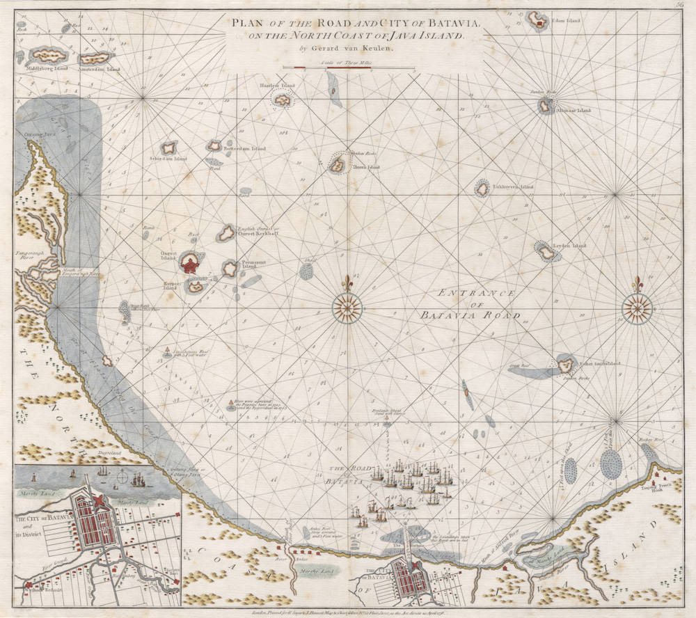
Plan of the Road and City of Batavia, on the North Coast of Java Island.
First Published
Amsterdam, 1728
This Edition
1778 Sayer Bennett version
Size
57.7 x 51.3 cms
Technique
Condition
excellent
Price
This Item is Sold
Description
Plan of the Road and City of Batavia, on the North Coast of Java Island. by Gerard van Keulen.
London, Printed for R Sayer & J Bennett Map & Chart Sellers No. 53 Fleet Street, as the Act directs 20 April 1778.
Important sea chart showing the harbour and surrounding waters of Batavia, the headquarters of the VOC in the far east. With an additional inset of the city plan.
The prototype for this large VOC chart of Batavia roads was first issued by Gerard van Keulen in 1728 for Volume V of the Zeefakkel (Sea Torch). From 1753 onwards it was included in Volume VI, the secret atlas of the VOC.
This is the equally rare English copy of the chart that was first issued in 1778 by Sayer and Bennett in London. A second state is known wuth the address of Laurie and Whittle, with the date 1794.
The chart here is a faithful copy of van Keulen's chart, with all legends and navigational details translated to English.
Many ships are anchored, reflecting that this was one of the busiest ports of the far east.
Condition
Some strengthening of old vertical folds, which is normal for such large sea charts. Printed on thick paper, intended for use at sea in humid and salty air conditions. Very mild spotting overall. A good impression of the copperplate. Later colour, subdued and well done, better than with most charts by Sayer & Bennett. Overall in excellent collector's condition.
The roadsteads of Batavia
The full roadsteads extended all the way from the Krawangse to the Ruige Hoek [Rough Hook] or Ontong Java. Including all the islets within, this area was under authority of the Commander or Provisions master, in his role as chief of the navy.
The Commander held residence in a house dating back to 1644, which was part of a row of buildings south of the shipyard gate. That house was generally referred to as the 'palace'. The chief official was a gentleman of greatest authority, master of the naval power of the Company, and as such responsible for the unloading, loading, equipping, provisioning [victualing], manning and carpentry repairing of the VOC ships. Under his authority were the Wharf (Shipyard ashore), the Vierkant [customs clearance buildings], Onrust island, Kuyper island (both naval base and ship repair yards, Edam island (lighthouse), the ships in the harbor, the staff at the harbour canal, of the proas [pirogues, Indonesian boats] house and those on the ‘onderlegger’ [a special purpose type of flat boat], which served to repair ships on the roadstead [carpentry maintenance while in the water, bigger repairs were done on the shipyards]. The ‘man of great authority’ had at his disposal his own sloop, under command of the High Boatswain.
The admiralty- or guard-ship, already mentioned in 1654 and waving its flag from the main mast, was not directly governed by the commander, who lived on the wharf, but by a skipper. It served as depot of ships’ crew and for that reason it was named ‘Mits desen’ [‘Provided that’], after the initial wording of the official transfer form. From this guard ship, every morning after reveille [the official trumpet call to signal wake up] the morning [cannon] shot was fired, while and in the evening after the tattoo [the official trumpet call to signal the end of the day] the evening shot was fired as signal for the other ships.
Sometimes more than a hundred ships were anchored at the roadsteads, the majority larger and smaller ships of the Company. A sloop called the labberlot (‘homeless’ or ‘vagabond’), maintained the connection with the shore. Every ship had at its disposition its own victualling prao, referred to as ‘biermaat’ [lit: beer friend] or ‘kadraaier’ [after Portuguese catraeiro, a peddler/sutler ship], the Chinese owner of which traded with the crew. The Water Fiscal's duty was to ensure that no smuggling took place, but, for a small fee, he occasionally was inclined to look the other way …
Johannes van Keulen (1654-1711)
Gerard van Keulen (son) (1678-c.1727)
Johannes van Keulen II (grandson) (active 1726-1755)
The Dutch produced a remarkable number of enterprising and prolific map and chart makers but not even the Blaeu and Jansson establishments could rival the vigour of the van Keulen family whose business was founded in 1680 and continued under their name until 1823 and in other names until 1885 when it was from wound up and the stock dispersed at auction.
Throughout the history of the family, the widows several of the van Keulens played a major part, after their husbands' deaths, in maintaining the continuity of the business. The firm was founded by Johannes van Keulen who was registered as a bookseller in Amsterdam in 1678. In 1680 he published the first part of his 'Zee Atlas' which, over the years, was expanded to 5 volumes and continued in one form or another until 1734. More ambitious and with a far longer and more complicated life was his book of sea charts, the 'Zee-Fakkel', first published in 1681–82, which was still being printed round the year 1800. A major influence in the development of the firm was the acquisition in 1693 of the stock of a rival map publisher, Hendrik Doncker.
Although the firm was founded by Johannes van Keulen, he was primarily a publisher; it was his son, Gerard, a talented engraver, mathematician, Hydrographer to the East India Company, who became mainspring of the business which not only published charts but also books on every aspect of geograpy, navigation and nautical matters,
(Moreland and Bannister)
It was grandson Johannes van Keulen (II) who in 1753 produced Volume VI of the Zee-Fakkel for the VOC East Indiamen, containing printed charts for the navigation covering the waters from the Cape of Good Hope to Nagasaki . The atlas was not commercially sold and only for use on board of VOC ships, therefore it is also refered to as the 'secret atlas' odf the VOC. The engraving quality and craftmanship surpasses that of all earlier printed sea charts.
Sea charts from the secret atlas are among the rarest and most desirable sea charts for collectors.
Related Categories
Related Items


