Leen Helmink Antique Maps
Antique map of Asia by Visscher
The item below has been sold, but if you enter your email address we will notify you in case we have another example that is not yet listed or as soon as we receive another example.

Stock number: 18960
Zoom ImageCartographer(s)
Nicolaes Visscher I (biography)
Title
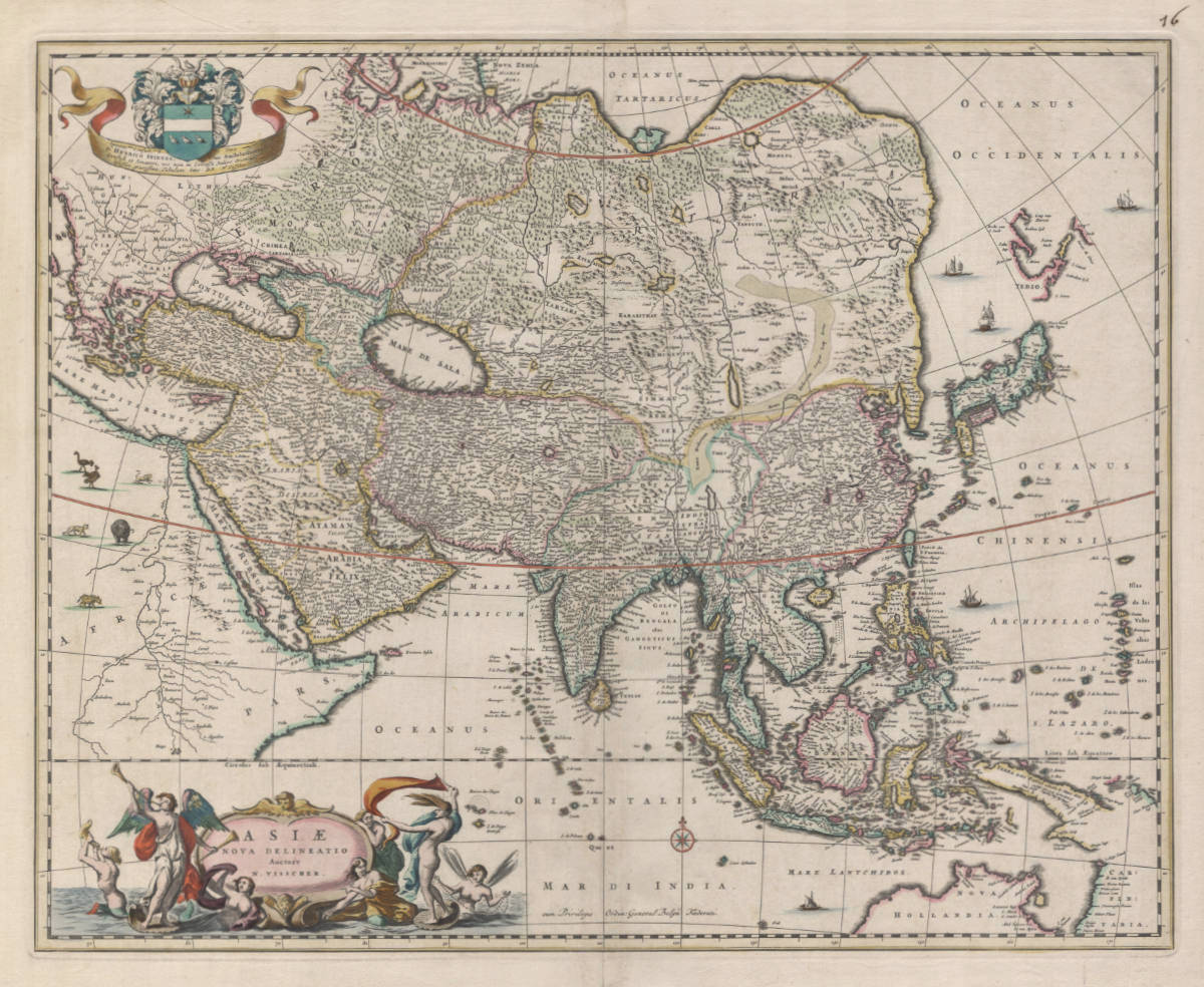
ASIAE nove delineatio
First Published
Amsterdam, 1658
This Edition
1677
Size
43.2 x 54.2 cms
Technique
Condition
mint
Price
This Item is Sold
Description
Beautiful cornerstone map of Asia, decorated with spectacular allegories of the sea gods. The map would be the standard map of Asia for the second half of the 17th century.
It is one of the earliest obtainable maps to show in detail the Tasman discoveries of 1644, in the Gulf of Carpentaria and the northern coast of Australia. Even though Tasman, like his predecessors, did not find Torres Strait, the possibility of it's existence is left open on this map. Note that many of the toponyms resulting from this voyage refer to Antonio van Diemen (or his wife Maria). Van Diemen was the Governor-General in Batavia who commissioned the Tasman voyages of 1642-43 and 1644.
The map also has the discoveries north of Japan, from the 1643 expedition of Maarten Gerritszoon de Vries. That expedition had also been commissioned by Antonio van Diemen, to search for the legendary gold and silver islands in the Pacific. It was a secret voyage, because the Japanese shogun, who was an excellent trading partner of the VOC, did not allow any charting of the coasts of Japan by foreign entities.
The map is dedicated to Hendrik Dirkszoon Spiegel, who was mayor of Amsterdam and one of the directors of the VOC chamber of Amsterdam. This makes it highly likely that the copperplate was engraved in 1659.
Condition
Dark and even imprint of the copperplate. Thick paper with wide margins all around. Stunning contemporary color, applied by the Visscher publishing house at the time of production of the atlas. Pristine collector's condition.
Claes Janszoon Visscher 1587-1652
Nicolaes Visscher I (son) 1618-1679
Nicolaes Visscher II (grandson) 1649-1702
Elisabeth Visscher (widow of N. Visscher II)
"For nearly a century the members of the Visscher family were important art dealers and map publishers in Amsterdam. The founder of the business, Claes Janszoon Visscher, had premises near to those of Pieter van den Keere and Jodocus Hondius whose pupil he may have been.
From about 1620 he designed a number of individual maps, including one of the British Isles, but his first atlas consisted of maps printed from plates bought from van den Keere and issued as they stood with some additions of his own, including historical scenes of battles and sieges for which he had a high reputation.
Some maps bear the latinized form of the family name: Piscator. After Visscher's death his son and grandson, both of the same name, issued a considerable number of atlases, constantly revised and brought up to date but most of them lacking an index and with varying contents.
The widow of Nicholaes Visscher II carried on the business until it finally passed into the hands of Pieter Schenk."
(Moreland & Bannister).
Related Categories
Antique maps of the East India Company
Antique maps of Russia
Antique maps of Australia
Antique maps of Japan
Antique maps of China
Antique maps of the Philippines
Antique maps of Southeast Asia
Antique maps of India and Ceylon
Antique maps of Korea
Antique maps of the Middle East
Antique maps of Asia
Old books, maps and prints by Nicolaes Visscher I


