Leen Helmink Antique Maps
The first maps of Thailand and of Sumatra

Stock number: 19815
Zoom ImageCartographer(s)
Benedetto Bordone (biography)
Title
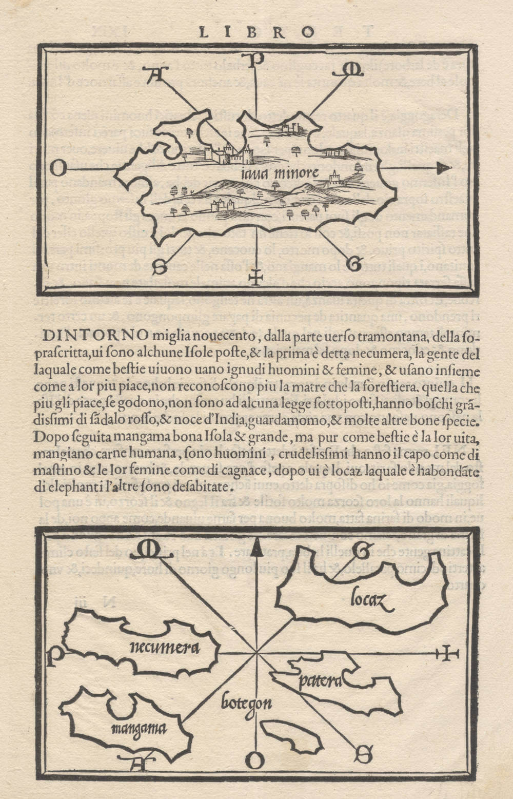
Iaua Minore .. Locaz ..
First Published
Venice, 1528
Size
30.0 x 20.7 cms
Technique
Condition
mint
Price
$ 750.00
(Convert price to other currencies)
Description
Pristine example of the extremely early map.
This pair of woodcut maps from Benedetto Bordone's *Isolario* (1528) illustrates the Southeast Asian archipelago, prominently featuring Iaua Menore (Java Minor), alongside Sumatra and Locaz (Lochac). Published in Venice by Nicolò d'Aristotile, known as Zoppino, the Isolario (formally titled 'Libro di Benedetto Bordone nel qual si ragiona di tutte l'isole del mondo secondo l'ordine di Tolomeo et di molti altri autori antichi et moderni') represents a seminal contribution to the early modern isolario genre.
This genre, pioneered by Bartolomeo dalli Sonetti in 1485 and Henricus Martellus in 1490, combined textual descriptions with schematic maps of islands, aligning classical authorities like Ptolemy with contemporary explorations.
Bordone's work, in its first edition of 1528, incorporates recent Portuguese discoveries in the Indian Ocean.
The upper map depicts Iaua Minore, one of the islands described by Marco Polo, adorned with a eight-point compass rose for wind directions. The island is identified with Sumatra, and this map is considered the first map dedicated to the island.
The lower map shows a cluster of islands, including Marco Polo's Lochac, which refers to a region on mainland Southeast Asia around the Gulf of Thailand, and is therefore considered the first map dedicated to Thailand.
Rarity
Rare.
Significance
The maps are the first maps of the island Iava Minore (Sumatra) and the region/island of Locaz (Thailand), as derived from Marco Polo's account.
Condition description
No restorations or imperfections. Strong paper, not cleaned or bleached as often. Dark and even imprint of the woodblock. Mint collector's example.
Benedetto Bordone (1460-1539)
Born in Padua, Bordone trained as an “illuminator and wood-engraver, working in Venice where, in 1508, he was given permission by the Senate to print maps of Italy and the world. No copies of these maps seem to have survived and he is known, therefore, only for his Isolario, printed in Venice in 1528.
Although issued as an ‘Island Book’ it gave prominence to discoveries in the New World and contained three full-size woodcut maps: the World, on an oval projection probably devised by the Florentine engraver, Francesco Rosselli, a map of Europe as a whole, and one of Greece and the North-Eastern Mediterranean. The remainder, about 80 woodcuts, are small maps or ‘charts' set in the text of the book,
(Moreland & Bannister).


