Leen Helmink Antique Maps
Antique map of Java by van Keulen
The item below has been sold, but if you enter your email address we will notify you in case we have another example that is not yet listed or as soon as we receive another example.

Stock number: 18925
Zoom ImageCartographer(s)
Gerard van Keulen (biography)
Title
Insulae Iavae Pars Occidentalis [&] Insulae Iavae Pars Orientalis
First Published
Amsterdam, 1728
This Edition
1728
Size
51 x 120 cms
Technique
Condition
excellent
Price
This Item is Sold
Description
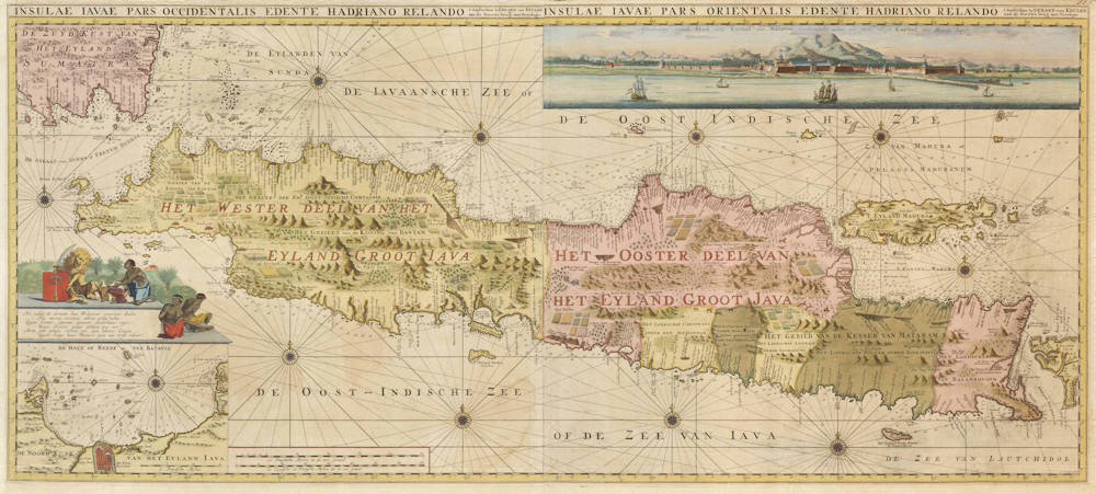
A highly important map, and the first accurate map of the island and its surrounding waters. Here in the rare first state with the decorative insets.
The map is printed from two copper plates and on two sheets of paper. In some atlases, it is included as two separate sheets, while it sometimes - like here - is assembled as one majestic chart of the whole of Java.
Being the official mapmaker of the Dutch East India Company, Gerard van Keulen had access to all the latest Company charts and he put a lot of effort in this map, to make it as decorative and accurate as possible to please his VOC directors.
There are hundreds of depth soundings on the chart, as well as safe anchorages.
The upper right has a beautiful panorama view of Batavia, the seat of the VOC in the East Indies and "the Paris of the East".
The lower left has an inset chart of the port and roadstead of Batavia, with the numerous islands including Onrust, the best shipyard of the eastern hemisphere (according to James Cook, whose Endeavour was severely leaking and was repaired there by the VOC in 1770).
The inset of the roadstead is topped by a pedestal with the coat of arms of Batavia, introduced on August 15, 1620, shortly after the capture and renaming of the small town of Jacatra in May 1619. The seal was decreed by Jan Pieterszoon Coen, Governor General of the Dutch East India Company. It is the oldest western heraldic arms ever granted in Asia. The arms are described as an orange shield with a blue sword surrounded by a brown laurel wrath. The shield is held by the Dutch lion, who is exchanging trading good with a Javanese. A fortress flying the Dutch colours is in the background. At the bottom of the pedestal are two chained natives who are not on board.
Before 1619, the VOC used Bantam as their headquarters in the archipelago, but the relation with the sultan was never optimal. Batavia was a friendlier environment, it had a good supply of fresh water, and it's bay and surrounding waters are full of small islands, all of which were then heavily fortified to make it impossible for adversaries to approach the port.
Batavia was the old Roman Latin word for the ancestors of the Dutch people. Coen had proposed the name Nieuw Hoorn for the city, after his home town of Hoorn, but the VOC directors did not want to give him too much prestige. Coen was tough, and he was respected and feared by his superiors, as much as by the English and Portuguese or Spanish adversaries.
The city was designed from scratch as a typical 17th century Dutch walled city, complete with canals, canal houses, drawbridges, churches, an impressive town hall, prison, hospital, gallow fields, etc. The city and roadstead were overlooked by a large castle, that was the seat of the Governor General.
The interior of the island mentions the major kingdoms and high mountain ranges. Volcanos are shown, as well as rice paddies, elephants, wild animals, jungles. There are multiple remarks that the island is very populous. The island was not controlled or governed by the Dutch but by local rulers. The VOC kept control over a handful of fortresses and strategic ports, and made divide-and-conquer treaties with the local sultans.
The East Indies were not colonized until the Napoleonic wars, after the bankruptcy of the VOC, when Stamford Raffles, founder of Singapore, occupied the Dutch East Indies for the British from 1811-1816.
The VOC set up a small lookout named fort Orange on the western point of Java, to spot any ships or fleets arriving at Sunda Strait, day and night. A little yacht would quickly meet and greet them, with much needed fresh victuals, and exchange the latest news from Europe, from the Indies, and about ships that had been dispatched from or to Cape Town and Patria. For safety, ships usually sailed in fleets, but it was very common to lose track of each other, especially in storms.
In bad weather, flag signals were used instead of being greeted by a yacht. The news was quickly relayed by courier to Batavia, to prepare offloading the incoming cargo and to redistribute the non-sailors (civilians and soldiers) to strongholds of the VOC in the region. For instance, countless bookkeepers, carpenters, construction workers, merchants and soldiers were needed to populate the fortresses from Ceylon, Mauritius and Batavia all the way to the Spice Islands, Taiwan and Japan.
Coming from the Cape of Good Hope, hitting tiny Sunda Strait after months of crossing the open waters of the Indian Ocean - with usually no landmarks or islands for calibration - was quite an impressive navigational achievement, like hitting the proverbial fly on a very distant wall. And it was essential to get it first time right, because ending up in the doldrums west of Sumatra or south of Java in the age of sail could easily result in many weeks of delays and miseries. Fortunately the volcano of Krakatau (Krakatoa) in Sunda Strait was a 2750 feet tall orientation point at the time (before the 1883 eruption the summit was much higher than after the eruption). The volcano or it's smoke could sometimes be seen from very far out, allowing for last minute corrections.
Captains and steersmen were very motivated and eager to get it right, because the VOC paid high success bonuses for fast crossings from Patria to Cape Town and from Cape Town to Batavia and vice versa. Fat crossings meant more profit and healthier crews. Captains were obliged to port in at Cape Town for at least ten days, to allow the crew to recover from scurvy or other diseases.
It took two to three days to sail from the entrance of Sunda Strait to Batavia. To sail through narrow Sunda Strait, four promontories or "hooks" need to be rounded (after the Dutch hoek, or old english "hoke", meaning corner or angle). With Java's western end being the "First Hook", ships entered a sttrait named "Behouden Passagie", meaning "Safe Passage (of the Indian Ocean)". They then rounded the "Second Hook", entering "Welkomst Baey" (Welcome Bay). Day or night, dozens of Chinese junks would come out to sell fresh water, fruits, vegetables, meat, and so on. After rounding the "Third hook", ships had to navigate the treacherous neck of Sunda, with many rocks and shoals. To complicate metters, the island "Dwars in de Weg" was right in the middle blocking the center of the narrow strait. After rounding the fourth hook ("Bantams hook"), it was a day of easy blue weather sailing to the roadstead of Batavia.
Condition description
An early strong and even imprint of the copper plates. Paper slightly mellow, but very authentic. Small tear repaired in lower left margin, touching into the plan of the city of Batavia. Gorgeous original colour. Wide margins all around. Overall a very desirable example of a seminal chart.
Johannes van Keulen (1654-1711)
Gerard van Keulen (son) (1678-c.1727)
Johannes van Keulen II (grandson) (active 1726-1755)
The Dutch produced a remarkable number of enterprising and prolific map and chart makers but not even the Blaeu and Jansson establishments could rival the vigour of the van Keulen family whose business was founded in 1680 and continued under their name until 1823 and in other names until 1885 when it was from wound up and the stock dispersed at auction.
Throughout the history of the family, the widows several of the van Keulens played a major part, after their husbands' deaths, in maintaining the continuity of the business. The firm was founded by Johannes van Keulen who was registered as a bookseller in Amsterdam in 1678. In 1680 he published the first part of his 'Zee Atlas' which, over the years, was expanded to 5 volumes and continued in one form or another until 1734. More ambitious and with a far longer and more complicated life was his book of sea charts, the 'Zee-Fakkel', first published in 1681–82, which was still being printed round the year 1800. A major influence in the development of the firm was the acquisition in 1693 of the stock of a rival map publisher, Hendrik Doncker.
Although the firm was founded by Johannes van Keulen, he was primarily a publisher; it was his son, Gerard, a talented engraver, mathematician, Hydrographer to the East India Company, who became mainspring of the business which not only published charts but also books on every aspect of geograpy, navigation and nautical matters,
(Moreland and Bannister)
It was grandson Johannes van Keulen (II) who in 1753 produced Volume VI of the Zee-Fakkel for the VOC East Indiamen, containing printed charts for the navigation covering the waters from the Cape of Good Hope to Nagasaki . The atlas was not commercially sold and only for use on board of VOC ships, therefore it is also refered to as the 'secret atlas' odf the VOC. The engraving quality and craftmanship surpasses that of all earlier printed sea charts.
Sea charts from the secret atlas are among the rarest and most desirable sea charts for collectors.


