Leen Helmink Antique Maps
Antique map of the Pacific by Janssonius
The item below has been sold, but if you enter your email address we will notify you in case we have another example that is not yet listed or as soon as we receive another example.

Stock number: 18917
Zoom ImageCartographer(s)
Johannes Janssonius (biography)
Title
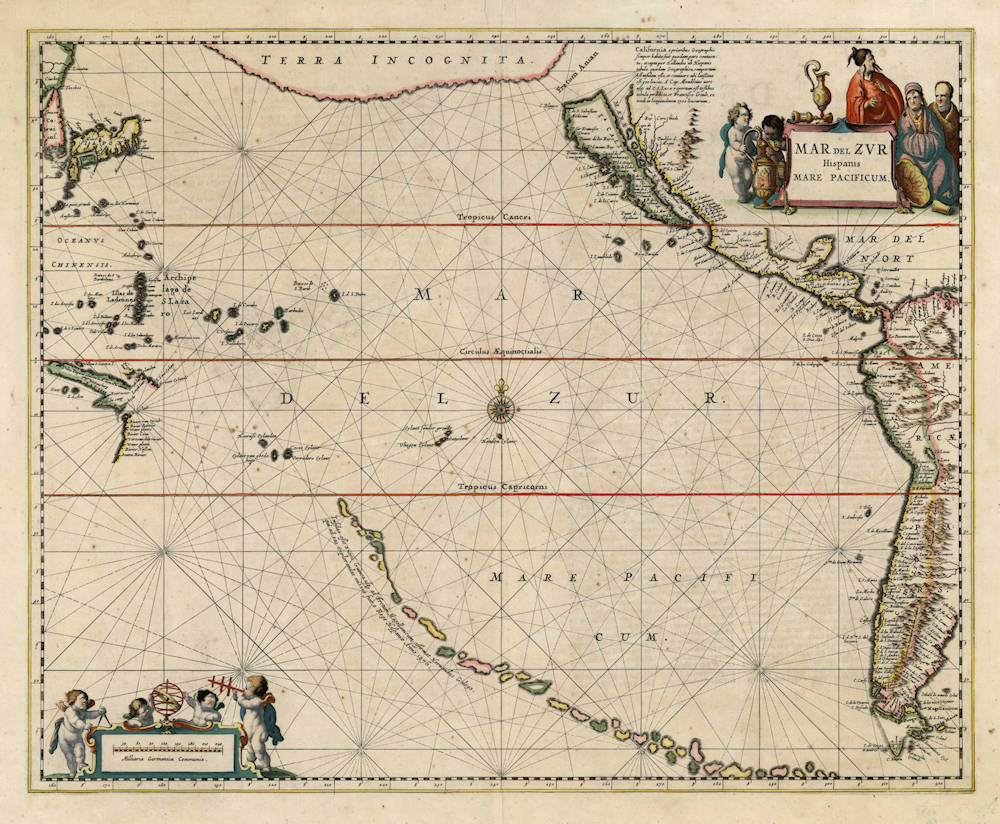
MAR del ZUR Hispanis Mare Pacificum
First Published
Amsterdam, 1650
This Edition
1650 first edition
Size
44 x 55 cms
Technique
Condition
excellent
Price
This Item is Sold
Description
First state of this seminal sea chart of the Pacific. From the first edition (1650 Latin).
Condition
Excellent example. Thick paper with wide margins, no discoloration. Unobtrusive spotting in the margins. Strong early imprint of the copperplate. In attractive original colour. No imperfections or restorations. Collector condition.
First state of Jansson's map of the Pacific showing the Dutch discoveries in Cape York Peninsula by Carstensz in 1623
Jansson produced his first Atlas Novus in three volumes, in 1638. As a result of intense competition by other map publishers, notably by Blaeu, Jansson proceeded to expand on that atlas, adding new parts and volumes. In 1650, he introduced a sea atlas as part V of Atlas Novus, described by Koeman as the first sea atlas. It contained a number of finely executed charts, including this one of the Pacific.
Carstensz's 1623 exploits on the west coast of Cape York Peninsula are charted and include the place names given during the expedition. Here in the first state, Tasman's discoveries in Australia have not yet been recorded, but they are in the rare second state of the map.
California is typically depicted as an island, while a peculiar string of islands stretching from Tierra del Fuego towards New Guinea are shown. Herman Gallego, chief pilot on Mendana's first voyage, was reported to have sighted these fictitious islands in 1576, and they started appearing on a few from the mid 17th century including Hondius' Polus Antarcticus. More than likely they represent the remnants of Terra Australis Incognito. The northern Pacific is dominated by a large Terra Incognita.
A very scarce edition showing Tasman's discoveries also exists and acccording to Philip Burden shows the confusion regarding the Kuriles north of Japan, by Maerten Gerritsz Vries. This second state is known to be bound into an atlas by Abraham Wolfgang (c.1688) in the Library of Congress.
(Simon Dewez)
The chain of islands in the lower right are the orphaned islands from the Terra Australis of the Hondius-Le-Clerc map. Above it are islands discovered by Le Maire, and New Guinea and the western coast of Carpentaria.
(Thomas Suarez)
Johannes Janssonius (1588-1664)
Johannes Janssonius, more commonly known to us as Jan Jansson, was born in Arnhem where his father was a bookseller and publisher (Jan Janszoon the Elder). In 1612 he married the daughter of the cartographer and publisher Jodocus Hondius, and then set up in business in Amsterdam as a book publisher. In 1616 he published his first maps of France and Italy and from then onwards he produced a very large number of maps, perhaps not quite rivalling those of the Blaeu family but running a very close second in quantity and quality. From about 1630 to 1638 he was in partnership with his brother-in-law, Henricus Hondius, issuing further editions of the Mercator/Hondius atlases to which his name was added. On the death of Henricus he took over the business, expanding the atlas still further, until eventually he published an 11-volume "Atlas Major" on a scale similar to Blaeu's "Atlas Maior".
The first full edition of Jansson’s English County Maps was published in 1646 but some years earlier he issued a number of British maps in the Mercator/Hondius/ Jansson series of atlases (1636–44); the maps were printed from newly engraved plates and are different from the later 1646 issue and are now rarely seen. In general appearance Jansson’s maps are very similar to those of Blaeu and, in fact, were often copied from them, but they tend to be more flamboyant and, some think, more decorative.
After Jansson's death his heirs published a number of maps in an "Atlas Contractus" in 1666 and later still many of the plates of his British maps were acquired by Pieter Schenk and Gerard Valck, who published them again in 1683 as separate maps.
(Moreland and Bannister)
Related Categories
Antique maps of the South Pole
Antique maps of the East India Company
Antique maps of Australia
Antique maps of Japan
Antique maps of Korea
Antique maps of the United States
Antique maps of South America
Antique maps of Central America
Antique maps of North America
Antique maps of Canada
Antique maps of America
Old books, maps and prints by Johannes Janssonius


